

Riverine barriers and the geographic distribution of Amazonian species
- PMID: 11095705
- PMCID: PMC17634
- DOI: 10.1073/pnas.230136397
Riverine barriers and the geographic distribution of Amazonian species
Abstract
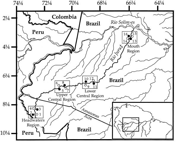
Rivers have been suggested to have played an important role in shaping present-day patterns of ecological and genetic variation among Amazonian species and communities. Recent molecular studies have provided mixed support for the hypothesis that large lowland Amazonian rivers have functioned as significant impediments to gene flow among populations of neotropical species. To date, no study has systematically evaluated the impact that riverine barriers might have on structuring whole Amazonian communities. Our analyses of the phylogeography of frogs and small mammals indicate that a putative riverine barrier (the Juruá River) does not relate to present-day patterns of community similarity and species richness. Rather, our results imply a significant impact of the Andean orogenic axis and associated thrust-and-fold lowland dynamics in shaping patterns of biotic diversity along the Juruá. Combined results of this and other studies significantly weaken the postulated role of rivers as major drivers of Amazonian diversification.
Figures
Comment in
-
A barrier runs through it... or maybe just a river.Proc Natl Acad Sci U S A. 2000 Dec 5;97(25):13470-2. doi: 10.1073/pnas.250497697. Proc Natl Acad Sci U S A. 2000. PMID: 11095757 Free PMC article. No abstract available.
References
-
- Wilson E O. The Diversity of Life. New York: Norton; 1992.
-
- Gaston K J, Williams P H. In: Biodiversity: A Biology of Numbers and Difference. Gaston K J, editor. Cambridge, MA: Blackwell Science; 1996. pp. 202–229.
-
- Pianka E R. Am Nat. 1966;100:33–46.
-
- Terborgh J. Am Nat. 1973;107:481–501.
-
- Rhohde K. Oikos. 1992;65:514–527.
Publication types
MeSH terms
LinkOut - more resources
Full Text Sources
