

Familiar route loyalty implies visual pilotage in the homing pigeon
- PMID: 15572457
- PMCID: PMC536010
- DOI: 10.1073/pnas.0406984101
Familiar route loyalty implies visual pilotage in the homing pigeon
Abstract
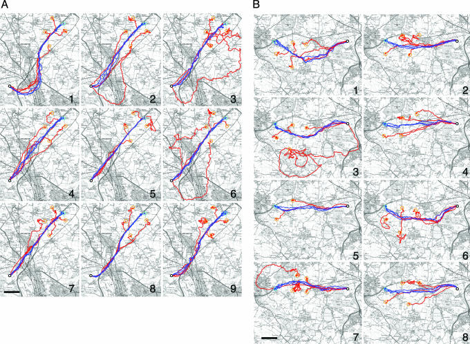
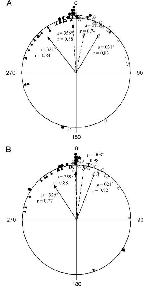
Wide-ranging animals, such as birds, regularly traverse large areas of the landscape efficiently in the course of their local movement patterns, which raises fundamental questions about the cognitive mechanisms involved. By using precision global-positioning-system loggers, we show that homing pigeons (Columba livia) not only come to rely on highly stereotyped yet surprisingly inefficient routes within the local area but are attracted directly back to their individually preferred routes even when released from novel sites off-route. This precise route loyalty demonstrates a reliance on familiar landmarks throughout the flight, which was unexpected under current models of avian navigation. We discuss how visual landmarks may be encoded as waypoints within familiar route maps.
Figures
Similar articles
-
Homing pigeons develop local route stereotypy.Proc Biol Sci. 2005 Jan 7;272(1558):17-23. doi: 10.1098/rspb.2004.2873. Proc Biol Sci. 2005. PMID: 15875565 Free PMC article.
-
Pigeons combine compass and landmark guidance in familiar route navigation.Proc Natl Acad Sci U S A. 2007 May 1;104(18):7471-6. doi: 10.1073/pnas.0701575104. Epub 2007 Apr 23. Proc Natl Acad Sci U S A. 2007. PMID: 17452634 Free PMC article.
-
Route following and the pigeon's familiar area map.J Exp Biol. 2014 Jan 15;217(Pt 2):169-79. doi: 10.1242/jeb.092908. J Exp Biol. 2014. PMID: 24431141 Review.
-
The role of visual landmarks in the avian familiar area map.J Exp Biol. 2003 Jun;206(Pt 11):1773-8. doi: 10.1242/jeb.00365. J Exp Biol. 2003. PMID: 12727998
-
Requiem for a heavyweight - can anything more be learned from homing pigeons about the sensory and spatial-representational basis of avian navigation?J Exp Biol. 2018 Oct 22;221(Pt 20):jeb163089. doi: 10.1242/jeb.163089. J Exp Biol. 2018. PMID: 30348670 Review.
Cited by
-
Homing pigeons develop local route stereotypy.Proc Biol Sci. 2005 Jan 7;272(1558):17-23. doi: 10.1098/rspb.2004.2873. Proc Biol Sci. 2005. PMID: 15875565 Free PMC article.
-
Do release-site biases reflect response to the Earth's magnetic field during position determination by homing pigeons?Proc Biol Sci. 2009 Sep 22;276(1671):3295-302. doi: 10.1098/rspb.2009.0872. Epub 2009 Jun 25. Proc Biol Sci. 2009. PMID: 19556255 Free PMC article.
-
Turbulence causes kinematic and behavioural adjustments in a flapping flier.J R Soc Interface. 2024 Mar;21(212):20230591. doi: 10.1098/rsif.2023.0591. Epub 2024 Mar 20. J R Soc Interface. 2024. PMID: 38503340 Free PMC article.
-
The function of wall-following behaviors in the Mexican blind cavefish and a sighted relative, the Mexican tetra (Astyanax).J Comp Physiol A Neuroethol Sens Neural Behav Physiol. 2009 Mar;195(3):225-40. doi: 10.1007/s00359-008-0400-9. Epub 2008 Dec 18. J Comp Physiol A Neuroethol Sens Neural Behav Physiol. 2009. PMID: 19093125
-
Left or right, that is the question: use of egocentric frame of reference and the right-eye advantage for understanding gestural signs in bottlenose dolphins (Tursiops truncatus).Anim Cogn. 2023 Sep;26(5):1551-1569. doi: 10.1007/s10071-023-01799-6. Epub 2023 Jun 15. Anim Cogn. 2023. PMID: 37318674
References
-
- Wallraff, H. G. (2001) Ethol. Ecol. Evol. 13, 1–48.
-
- Wiltschko, R. & Wiltschko, W. (2003) Anim. Behav. 65, 257–272.
-
- Papi, F., ed. (1992) Animal Homing (Chapman & Hall, London).
-
- Bingman, V. P. (1998) in Spatial Representation in Animals, ed. Healy, S. (Oxford Univ. Press, New York), pp. 69–85.
-
- Wallraff, H. G., Kiepenheuer, J. & Streng, A. (1993) Behav. Ecol. Sociobiol. 32, 387–390.
Publication types
MeSH terms
LinkOut - more resources
Full Text Sources
