

A temporal-spatial analysis of bovine spongiform encephalopathy in Irish cattle herds, from 1996 to 2000
- PMID: 15745218
- PMCID: PMC1142165
A temporal-spatial analysis of bovine spongiform encephalopathy in Irish cattle herds, from 1996 to 2000
Abstract
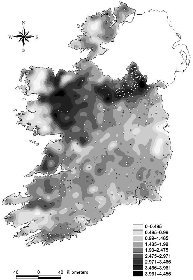
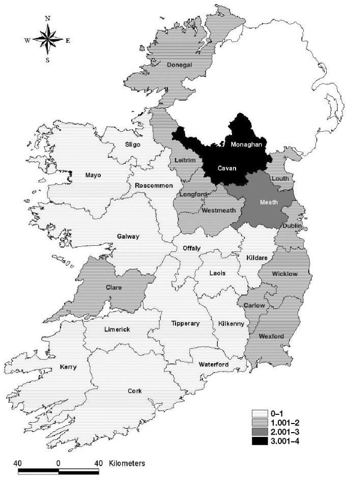
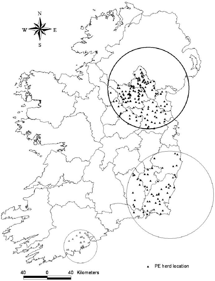
This study investigated the distribution of bovine spongiform encephalopathy (BSE) in herds of cattle in Ireland over the years 1996 through 2000, prior to the introduction of widespread active surveillance. Mappings of index herds, herd density, and standardized morbidity ratios, by county, were employed to help visualize areas of potential clustering of BSE. The hypothesis of spatial clustering was tested using a spatial scan statistic applied to the location of the herd where exposure likely occurred. Both Bernoulli and Poisson spatial models indicated marked clustering of BSE herds centred on Monaghan county, with secondary clusters detected by Bernoulli approaches and some Poisson models in Wexford and Cork. The number of cases increased with time, but clear temporal-spatial clusters were rarely detected, except in the case of a cluster in Wexford. The focussed spatial scan analyses using the location of large-scale feed suppliers provided support for the hypothesis that clustering of BSE may be associated with feed source. The results of our analyses provided strong evidence in support of the hypothesis that herds, in which animals were most likely to have been exposed to the BSE agent, cluster geographically.
La distribution de l’encéphalopathie spongiforme bovine (BSE) dans les troupeaux bovins en Irlande entre les années 1996 et 2000, avant l’introduction de méthode généralisée de surveillance active, a été investiguée. La cartographie des troupeaux index, la densité des troupeaux et les ratios standardisés de morbidité, par comté, a été employée afin d’aider à visualiser les régions de regroupement de cas de BSE. L’hypothèse de regroupement spatial a été testée en utilisant une statistique spatiale appliquée à la localisation du troupeau où l’exposition s’est probablement produite. Les modèles spatiaux de Bernoulli et Poisson indiquaient un regroupement marqué des troupeaux avec des cas de BSE centrés sur le comté de Monaghan, avec des regroupements secondaires détectés avec les approches de Bernoulli et quelques modèles de Poisson dans les comtés de Wexford et Cork. Le nombre de cas a augmenté avec le temps, mais des regroupements temporo-spatial évidents ont rarement été détectés, sauf dans le cas d’un regroupement dans le comté de Wexford. Les analyses spatiales ciblées en utilisant la localisation des distributeurs importants de nourriture ont fourni des évidences pour appuyer l’hypothèse que le regroupement des cas de BSE puisse être associer avec une source alimentaire. Les résultats de nos analyses apportent des preuves pour soutenir l’hypothèse que les troupeaux, dans lesquels des animaux sont susceptibles d’avoir été exposés à l’agent du BSE, sont regroupés géographiquement.
(Traduit par Docteur Serge Messier)
Figures
References
-
- Wells GAH, Scott AC, Johnson CT, et al. A novel progressive spongiform encephalopathy in cattle. Vet Rec. 1987;121:419–420. - PubMed
-
- Wilesmith JW, Wells GAH, Cranwell MP, Ryan JBM. Bovine Spongiform Encephalopathy: Epidemiological Studies. Vet Rec. 1988;123:638–644. - PubMed
-
- Wilesmith JW, Ryan JBM, Atkinson MJ. Bovine spongiform encephalopathy; epidemiological studies on the origin. Vet Rec. 1991;128:199–203. - PubMed
-
- Wilesmith JW, Ryan JBM, Hueston WD. Bovine spongiform encephalopathy: Case-control studies of calf feeding practices and meat and bonemeal inclusion in proprietary concentrates. Res Vet Med. 1992;52:325–331. - PubMed
-
- Taylor DM, Woodgate SL, Atkinson MJ. Inactivation of the bovine spongiform encephalopathy agent by rendering processes. Vet Rec. 1995;137:605–610. - PubMed
MeSH terms
LinkOut - more resources
Full Text Sources