

Identification and characterization of larval and adult anopheline mosquito habitats in the Republic of Korea: potential use of remotely sensed data to estimate mosquito distributions
- PMID: 16011809
- PMCID: PMC1187914
- DOI: 10.1186/1476-072X-4-17
Identification and characterization of larval and adult anopheline mosquito habitats in the Republic of Korea: potential use of remotely sensed data to estimate mosquito distributions
Abstract
Background: Plasmodium vivax malaria reemerged in the Republic of Korea in 1993, with more than 2,000 cases reported in the northwestern part of the country over the last 10 years. To better assess the risk of malaria transmission we conducted a surveillance study to identify and characterize the habitats that produce potential Anopheles vector mosquitoes. Immature and adult mosquito collection data were incorporated into a Geographic Information System (GIS) along with remotely sensed satellite imagery, and imagery classified to land use to determine if remote sensing data could be used to estimate mosquito habitats.
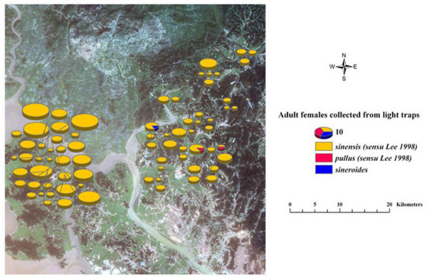
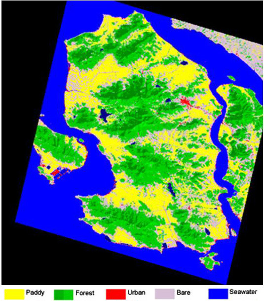
Results: More than 2,100 anopheline larvae were collected and mapped from 186 immature habitats, which were categorized into 9 types. Anopheles sinensis was the most commonly collected species, representing more than 97% of the specimens, followed by Anopheles pullus 1.0%, Anopheles lesteri 1.0%, and Anopheles sineroides 0.8%. Anopheles sinensis, pullus, and lesteri were found most frequently in rice paddies followed by: ditches, flooded areas, ground pools, wheel tracks, swamps, irrigation canals, and stream margins. Anopheles sineroides was found most commonly in flooded areas. Supervised classification was conducted on a LANDSAT 7 ETM+ image to identify 5-6 land-use classes that were considered to be of interest. The spatial distribution of the larval mosquito collections was overlaid on the land-use image derived from the LANDSAT image, and the number of mosquitoes habitats in each class calculated. On Ganghwa Island 67% of the immature habitats containing Anopheles sinensis were in the Paddy land-use class, although the class only represented 17% of the land area. In Paju District 53% of the immature habitats containing Anopheles sinensis were in the Paddy land-use class which represented only 9 % of the area of the district. There was significant (p < 0.05) correlation between habitats containing all four species and land use on Ganghwa Island; however, only Anopheles sinensis was significantly correlated with land-use in Paju District. In Ganghwa Island almost 50% of the Anopheles sinensis adults were collected in the paddy land-use class, and there was a positive correlation between larval and adult distributions. However, in Paju District adult Anopheles sinensis adults were most commonly collected in the Bare land-use class and only 17% collected in the Paddy class. There was a negative correlation between larval and adult distributions.
Conclusion: Immature habitats most commonly associated with Anopheles sinensis, Anopheles pullus, Anopheles sineroides and Anopheles lesteri were flooded rice paddies. Adult Anopheles sinensis, the most commonly collected anopheline, were found closely associated with rice habitats on Ganghwa Island but not in Paju District. Both QuickBird and LANDSAT satellite data were used to display spatial data in the form of geographic coverage and descriptive information in the form of relational databases associated with the mapped features. Supervised classification of LANDSAT imagery permitted good separation between Paddy, Forest, and Water land-use classes. The immature collections of Anopheles sinensis were significantly correlated with land-use as determined in the land-use classification in both Ganghwa Island and Paju District. These data suggest that classified remotely sensed data could potentially be used to estimate the distribution of immature and adult mosquito populations in the Republic of Korea.
Figures


References
-
- Sithiprasasna R, Linthicum KJ, Liu GJ, Jones JW, Singhasivanon P. Some entomological observations on temporal and spatial distribution of malaria vectors in three villages in northwestern Thailand using a geographic information system. Southeast Asian J Trop Med Public Health. 2003;34:505–516. - PubMed
-
- Sithiprasasna R, Linthicum KJ, Liu GJ, Jones JW, Singhasivanon P. Use of GIS-based spatial modeling approach to characterize the spatial patterns of malaria mosquito vector breeding habitats in northwestern Thailand. Southeast Asian J Trop Med Public Health. 2003;34:517–528. - PubMed
-
- Sithiprasasna R, Ugsang DM, Honda K, Jones JW, Singhasivanon P. IKONOS-derived malaria transmission risk in northwestern Thailand. Southeast Asian J Trop Med Public Health. 2005;36:14–22. - PubMed
-
- Claborn DM, Hshieh PB, Roberts DR, Klein TA, Zeichner BC, Andre RG. Environmental factors associated with larval habitats of malaria vectors in northern Kyunggi Province, Republic of Korea. J Am Mosq Control Assoc. 2002;18:178–185. - PubMed
-
- Cho SY, Kong Y, Park SM, Lee JS, Lim YA, Chae SL, Kho WG, Shim JC, Shin HK. Two vivax malaria cases detected in Korea. Korean J Parasitol. 1994;32:281–284. - PubMed
LinkOut - more resources
Full Text Sources
