

Altered environment and risk of malaria outbreak in South Andaman, Andaman & Nicobar Islands, India affected by tsunami disaster
- PMID: 16029514
- PMCID: PMC1188070
- DOI: 10.1186/1475-2875-4-30
Altered environment and risk of malaria outbreak in South Andaman, Andaman & Nicobar Islands, India affected by tsunami disaster
Abstract
Background: Pools of salt water and puddles created by giant waves from the sea due to the tsunami that occurred on 26th December 2004 would facilitate increased breeding of brackish water malaria vector, Anopheles sundaicus. Land uplifts in North Andaman and subsidence in South Andaman have been reported and subsidence may lead to environmental disturbances and vector proliferation. This warrants a situation analysis and vector surveillance in the tsunami hit areas endemic for malaria transmitted by brackish water mosquito, An. sundaicus to predict the risk of outbreak.
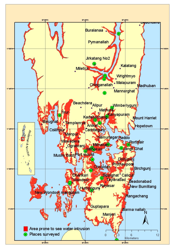
Methods: An extensive survey was carried out in the tsunami-affected areas in Andaman district of the Andaman and Nicobar Islands, India to assess the extent of breeding of malaria vectors in the habitats created by seawater flooding. Types of habitats in relation to source of seawater inundation and frequency were identified. The salinity of the water samples and the mosquito species present in the larval samples collected from these habitats were recorded. The malaria situation in the area was also analysed.
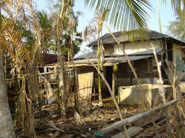
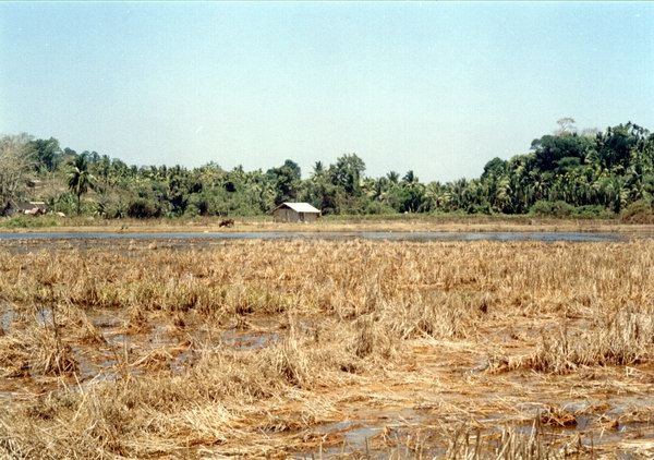
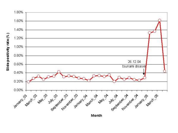
Results: South Andaman, covering Port Blair and Ferrargunj sub districts, is still under the recurring phenomenon of seawater intrusion either directly from the sea or through a network of creeks. Both daily cycles of high tides and periodical spring tides continue to cause flooding. Low-lying paddy fields and fallow land, with a salinity ranging from 3,000 to 42,505 ppm, were found to support profuse breeding of An. sundaicus, the local malaria vector, and Anopheles subpictus, a vector implicated elsewhere. This area is endemic for both vivax and falciparum malaria. Malaria slide positivity rate has started increasing during post-tsunami period, which can be considered as an indication of risk of malaria outbreak.
Conclusion: Paddy fields and fallow land with freshwater, hitherto not considered as potential sites for An. sundaicus, are now major breeding sites due to saline water. Consequently, there is a risk of vector abundance with enhanced malaria transmission potential, due to the vastness of these tsunami-created breeding grounds and likelihood of them becoming permanent due to continued flooding in view of land subsidence. The close proximity of the houses and paucity of cattle may lead to a higher degree of man/vector contact causing a threat of malaria outbreak in this densely populated area. Measures to prevent the possible outbreak of malaria in this tsunami-affected area are discussed.
Figures
Similar articles
-
Management of malaria threat following tsunami in Andaman & Nicobar Islands, India and impact of altered environment created by tsunami on malaria situation of the islands.Acta Trop. 2009 Nov;112(2):204-11. doi: 10.1016/j.actatropica.2009.07.028. Epub 2009 Aug 4. Acta Trop. 2009. PMID: 19660429
-
Towards eradication: three years after the tsunami of 2004, has malaria transmission been eliminated from the island of Simeulue?Trans R Soc Trop Med Hyg. 2010 Dec;104(12):777-81. doi: 10.1016/j.trstmh.2010.09.001. Epub 2010 Oct 16. Trans R Soc Trop Med Hyg. 2010. PMID: 20952042
-
[Current malaria situation in Turkmenistan].Med Parazitol (Mosk). 2001 Jan-Mar;(1):37-9. Med Parazitol (Mosk). 2001. PMID: 11548312 Russian.
-
El Niño and associated outbreaks of severe malaria in highland populations in Irian Jaya, Indonesia: a review and epidemiological perspective.Southeast Asian J Trop Med Public Health. 1999 Dec;30(4):608-19. Southeast Asian J Trop Med Public Health. 1999. PMID: 10928348 Review.
-
[Impact of changes in the environment on vector-transmitted diseases].Sante. 1997 Jul-Aug;7(4):263-9. Sante. 1997. PMID: 9410453 Review. French.
Cited by
-
Tsunami, post-tsunami malaria situation in Nancowry group of islands, Nicobar district, Andaman and Nicobar Islands.Indian J Med Res. 2011 Jan;133(1):76-82. Indian J Med Res. 2011. PMID: 21321423 Free PMC article.
-
Challenges in Understanding the Bionomics of Indian Malaria Vectors.Am J Trop Med Hyg. 2022 Sep 12;107(5):1005-1014. doi: 10.4269/ajtmh.22-0137. Print 2022 Nov 14. Am J Trop Med Hyg. 2022. PMID: 36096410 Free PMC article.
-
Characterization of the anopheline vector breeding habitats: Implications for elimination of malaria in tribal inhabited Car Nicobar Island.Indian J Med Res. 2022 Aug;156(2):240-249. doi: 10.4103/ijmr.ijmr_3189_21. Indian J Med Res. 2022. PMID: 36629183 Free PMC article.
-
Possible impact of rising sea levels on vector-borne infectious diseases.BMC Infect Dis. 2011 Jan 18;11:18. doi: 10.1186/1471-2334-11-18. BMC Infect Dis. 2011. PMID: 21241521 Free PMC article.
-
Effect of salinity on the oviposition and growth of Ochlerotatus togoi.Ecol Evol. 2024 Apr 23;14(4):e11289. doi: 10.1002/ece3.11289. eCollection 2024 Apr. Ecol Evol. 2024. PMID: 38660469 Free PMC article.
References
-
- WHO Technical Note: Malaria risk and malaria control in Asian countries affected by the tsunami disaster http://mosquito.who.int/docs/Asia_tsunami_malaria_risk-v1-5Jan.pdf
-
- World Health Organization Weekly Tsunami Situation Report. 2005. http://www.who.int/hac/crises/international/asia_tsunami/sitrep/30/en/
-
- Andaman and Nicobar Islands – at a glance 2004. Directorate of Economics & Statistics, Andaman and Nicobar Administration, Port Blair
-
- Ramanamurthy MV, Sundaramoorthy S, Pari Y, Ranga Rao V, Mishra P, Bhat M, Tune Usha, Venkatesan R, Subramanian BR. Inundation of sea water in Andaman and Nicobar Islands and part of Tamil Nadu coast during 2004 Sumatra tsunami. Curr Sci. 2005;88:1736–1740.
MeSH terms
LinkOut - more resources
Full Text Sources
Medical
