

Increased salinization of fresh water in the northeastern United States
- PMID: 16157871
- PMCID: PMC1224654
- DOI: 10.1073/pnas.0506414102
Increased salinization of fresh water in the northeastern United States
Abstract
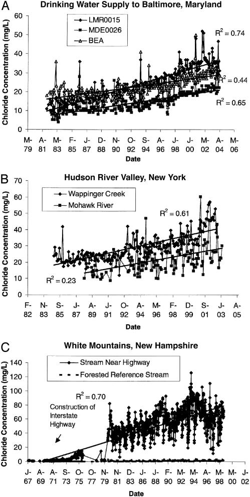
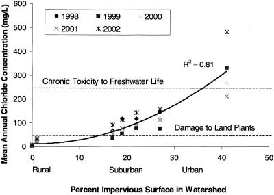
Chloride concentrations are increasing at a rate that threatens the availability of fresh water in the northeastern United States. Increases in roadways and deicer use are now salinizing fresh waters, degrading habitat for aquatic organisms, and impacting large supplies of drinking water for humans throughout the region. We observed chloride concentrations of up to 25% of the concentration of seawater in streams of Maryland, New York, and New Hampshire during winters, and chloride concentrations remaining up to 100 times greater than unimpacted forest streams during summers. Mean annual chloride concentration increased as a function of impervious surface and exceeded tolerance for freshwater life in suburban and urban watersheds. Our analysis shows that if salinity were to continue to increase at its present rate due to changes in impervious surface coverage and current management practices, many surface waters in the northeastern United States would not be potable for human consumption and would become toxic to freshwater life within the next century.
Figures
Comment in
-
From icy roads to salty streams.Proc Natl Acad Sci U S A. 2005 Oct 11;102(41):14487-8. doi: 10.1073/pnas.0507389102. Epub 2005 Oct 3. Proc Natl Acad Sci U S A. 2005. PMID: 16203970 Free PMC article. No abstract available.
References
-
- Williams, W. D. (2001) Hydrobiologia 466, 329-337.
-
- Peters, N. E. & Turk, J. T. (1981) Water Resour. Bull. 17, 586-597.
-
- Rosenberry, D. O., Bukaveckas, P. A., Buso, D. C., Likens, G. E., Shapiro, A. M. & Winter, T. C. (1999) Water Air Soil Poll. 109, 179-206.
-
- Godwin, K. S., Hafner, S. D. & Buff, M. F. (2003) Environ. Poll. 124, 273-281. - PubMed
-
- Siver, P. A., Canavan, IV, R. W., Field, C. K., Marsicano, L. J. & Lott, A. M. (1996) J. Environ. Qual. 25, 334-345.
Publication types
MeSH terms
Substances
LinkOut - more resources
Full Text Sources
Other Literature Sources
