. 2005 Oct 25;102(43):15352-6.
doi: 10.1073/pnas.0507723102. Epub 2005 Oct 17.

Sustainability of irrigated agriculture in the San Joaquin Valley, California

Affiliations

Sustainability of irrigated agriculture in the San Joaquin Valley, California

Gerrit Schoups et al. Proc Natl Acad Sci U S A. .

Abstract

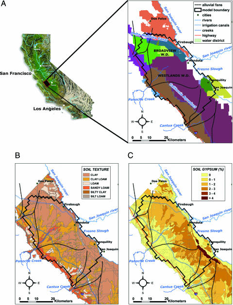
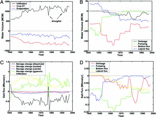
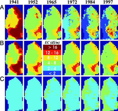
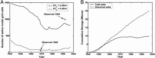
The sustainability of irrigated agriculture in many arid and semiarid areas of the world is at risk because of a combination of several interrelated factors, including lack of fresh water, lack of drainage, the presence of high water tables, and salinization of soil and groundwater resources. Nowhere in the United States are these issues more apparent than in the San Joaquin Valley of California. A solid understanding of salinization processes at regional spatial and decadal time scales is required to evaluate the sustainability of irrigated agriculture. A hydro-salinity model was developed to integrate subsurface hydrology with reactive salt transport for a 1,400-km(2) study area in the San Joaquin Valley. The model was used to reconstruct historical changes in salt storage by irrigated agriculture over the past 60 years. We show that patterns in soil and groundwater salinity were caused by spatial variations in soil hydrology, the change from local groundwater to snowmelt water as the main irrigation water supply, and by occasional droughts. Gypsum dissolution was a critical component of the regional salt balance. Although results show that the total salt input and output were about equal for the past 20 years, the model also predicts salinization of the deeper aquifers, thereby questioning the sustainability of irrigated agriculture.


Figures

Fig. 1.
Fig. 1.
Overview of the study area. (A) Location of the study area in the western San Joaquin Valley that includes 13 water districts (W.D.). (B) Soil texture map. (C) Soil gypsum contents. The main soil types are clay (52% of the study area), clay loam (35%), loam (4%), and sandy loam (9%). The finer-textured soils are found in the valley trough near the San Joaquin River. These soils have clay contents from 40% to 60%. The clay fraction is dominated by the montmorillonite mineral. Going from east to west, the soils gradually become more coarsely textured. A distinct feature is the sandy loam soils developed in stream deposits of Panoche Creek. Organic matter contents are low. Gypsum is predominantly present in the downslope soils. Soil data are from ref. .
Fig. 2.
Fig. 2.
Simulated water and salt fluxes. (A and B) Annual-averaged water fluxes for the western San Joaquin Valley [million m3 (MCM) divide by 1,372 million m2 (after 1970) to describe fluxes in m/yr; i.e., 1,000 MCM/yr corresponds to 72.8 cm/yr]. (C and D) Salt balance (Mton/yr) for the western San Joaquin Valley. Positive fluxes designate incoming salt, whereas positive storage terms reflect a decrease in storage. Salt import by infiltration is controlled by ion concentrations of rainfall, surface water, and pumped groundwater. Drainage, bottom flux through Corcoran clay, and lateral salt fluxes toward the San Joaquin Valley trough were generally negative, indicating an export of salts. A major source of dissolved salt was due to gypsum dissolution (green). Respective maxima in 1977 were caused by reduced surface water applications during the drought. The temporary increase in salt export by drainage in the early 1980s was a result of the operation of the Westlands water district drainage system, which was permanently closed down in 1986.
Fig. 3.
Fig. 3.
Temporal changes in the spatial distribution of dissolved salts, expressed by the electrical conductivity (EC, dS/m) of the average RZ (0–2 m below the land surface) (A), the shallow groundwater system (SGW; 6 m below the land surface) (B), and the deep groundwater system (DGW; 20–40 m below the land surface) (C). Clearly shown is the initially high RZ salinity in the Panoche-Cantua interfan area (southwestern portion of the study area) and the uniformly low salinity in the DGW. After 10 years of irrigation (1952), part of the initial salinity was leached, resulting in a decrease in RZ salinity. Some of the initial salinity was still present in the SGW. The DGW system on the other hand remained low in salinity. Leaching of RZ salts continued in the initial simulation period, with a sudden decrease in RZ salinity after switching from groundwater to surface water for irrigation in the 1960s. As water levels started to rise in the eastern part of the study area during the 1970s and 1980s, RZ salinity levels increased again due to the simulated increase in irrigation efficiency and capillary rise followed by evaporation as water tables became shallower. This trend of increasing salinity continued through the 1990s. The higher soil salinity in Broadview water district (northern area) was higher than the surrounding areas due to recycling of saline drainage water there.
Fig. 4.
Fig. 4.
Simulated salinity changes. (A) Time series of number of model grid cells with a simulated average RZ ECe > 4 dS/m (solid line) and >8 dS/m (dashed line). Symbols correspond to measured data. (B) Changes in total salt storage and dissolved salts (in Mton) since 1940.

References

    1. Tanji, K. K. & Kielen, N. C. (2002) Irrigation and Drainage Paper 61 (Food and Agriculture Organization, Rome).
    1. Ghassemi, F., Jakeman, A. J. & Nix, H. A. (1995) Salinisation of Land and Water Resources: Human Causes, Extent, Management and Case Studies (Centre for Resource and Environmental Studies, Canberra, Australia).
    1. Tilman, D., Cassman, K. G., Matson, P. A., Naylor, R. & Polasky, S. (2002) Nature 418, 671-677. - PubMed
    1. Maas, E. V. & Grattan, S. R. (1999) in Agricultural Drainage, eds. Skaggs, R. W. & van Schilfgaarde, J. (American Society of Agronomy, Madison, WI), pp. 55-110.
    1. Tanji, K. K. (1990) ASCE Manuals and Reports on Engineering Practices (American Society of Civil Engineers, New York), Vol. 71.

Publication types

LinkOut - more resources