

Pinpointing and preventing imminent extinctions
- PMID: 16344485
- PMCID: PMC1311739
- DOI: 10.1073/pnas.0509060102
Pinpointing and preventing imminent extinctions
Abstract
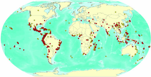
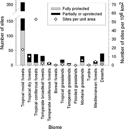
Slowing rates of global biodiversity loss requires preventing species extinctions. Here we pinpoint centers of imminent extinction, where highly threatened species are confined to single sites. Within five globally assessed taxa (i.e., mammals, birds, selected reptiles, amphibians, and conifers), we find 794 such species, three times the number recorded as having gone extinct since 1500. These species occur in 595 sites, concentrated in tropical forests, on islands, and in mountainous areas. Their taxonomic and geographical distribution differs significantly from that of historical extinctions, indicating an expansion of the current extinction episode beyond sensitive species and places toward the planet's most biodiverse mainland regions. Only one-third of the sites are legally protected, and most are surrounded by intense human development. These sites represent clear opportunities for urgent conservation action to prevent species loss.
Figures
References
-
- Pimm, S. L., Russell, G. J., Gittleman, J. L. & Brooks, T. M. (1995) Science 269, 347-350. - PubMed
-
- Balmford, A., Bennun, L., ten Brink, B., Cooper, D., Côté, I. M., Crane, P., Dobson, A., Dudley, N., Dutton, I., Green, R. E., et al. (2005) Science 307, 212-213. - PubMed
-
- Groves, C. R. (2003) Drafting a Conservation Blueprint: A Practitioner's Guide to Planning for Biodiversity (Island, Washington, DC).
-
- Margules, C. R. & Pressey, R. L. (2000) Nature 405, 243-253. - PubMed
-
- Olson, D. M. & Dinerstein, E. (1998) Conserv. Biol. 12, 502-515.
Publication types
MeSH terms
LinkOut - more resources
Full Text Sources
Other Literature Sources
