

Malaria risk on the Amazon frontier
- PMID: 16461902
- PMCID: PMC1413719
- DOI: 10.1073/pnas.0510576103
Malaria risk on the Amazon frontier
Abstract
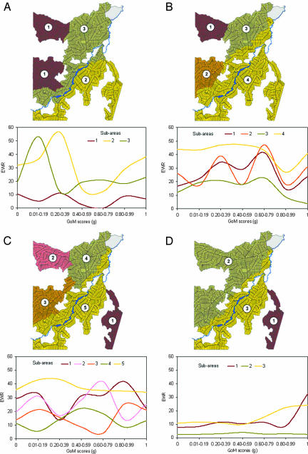
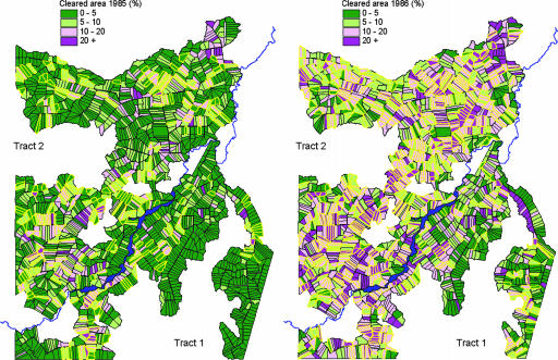
Frontier malaria is a biological, ecological, and sociodemographic phenomenon operating over time at three spatial scales (micro/individual, community, and state and national). We explicate these linkages by integrating data from remote sensing surveys, ground-level surveys and ethnographic appraisal, focusing on the Machadinho settlement project in Rondônia, Brazil. Spatially explicit analyses reveal that the early stages of frontier settlement are dominated by environmental risks, consequential to ecosystem transformations that promote larval habitats of Anopheles darlingi. With the advance of forest clearance and the establishment of agriculture, ranching, and urban development, malaria transmission is substantially reduced, and risks of new infection are largely driven by human behavioral factors. Malaria mitigation strategies for frontier settlements require a combination of preventive and curative methods and close collaboration between the health and agricultural sectors. Of fundamental importance is matching the agricultural potential of specific plots to the economic and technical capacities of new migrants. Equally important is providing an effective agricultural extension service.
Conflict of interest statement
Conflict of interest statement: No conflicts declared.
Figures


References
-
- Deane L. M. Am. J. Trop. Med. Hyg. 1988;38:223–230. - PubMed
-
- Sawyer D. R. Malaria and the Environment. Brasília: Instituto SPN; 1992.
-
- Stepan N. L. In: Disease in the History of Modern Latin America: From Malaria to AIDS. Armus D., editor. Durham, NC: Duke Univ. Press; 2003. pp. 25–50.
-
- Neiva A. Mem. Inst. Oswaldo Cruz. 1910;2:131–140.
-
- Neiva A. Rev. Clube Eng. 1940;VI:60–75.
Publication types
MeSH terms
LinkOut - more resources
Full Text Sources
Medical
