

A global assessment of closed forests, deforestation and malaria risk
- PMID: 16630376
- PMCID: PMC3204444
- DOI: 10.1179/136485906X91512
A global assessment of closed forests, deforestation and malaria risk
Abstract
Global environmental change is expected to affect profoundly the transmission of the parasites that cause human malaria. Amongst the anthropogenic drivers of change, deforestation is arguably the most conspicuous, and its rate is projected to increase in the coming decades. The canonical epidemiological understanding is that deforestation increases malaria risk in Africa and the Americas and diminishes it in South-east Asia. Partial support for this position is provided here, through a systematic review of the published literature on deforestation, malaria and the relevant vector bionomics. By using recently updated boundaries for the spatial limits of malaria and remotely-sensed estimates of tree cover, it has been possible to determine the population at risk of malaria in closed forest, at least for those malaria-endemic countries that lie within the main blocks of tropical forest. Closed forests within areas of malaria risk cover approximately 1.5 million km2 in the Amazon region, 1.4 million km2 in Central Africa, 1.2 million km2 in the Western Pacific, and 0.7 million km2 in South-east Asia. The corresponding human populations at risk of malaria within these forests total 11.7 million, 18.7 million, 35.1 million and 70.1 million, respectively. By coupling these numbers with the country-specific rates of deforestation, it has been possible to rank malaria-endemic countries according to their potential for change in the population at risk of malaria, as the result of deforestation. The on-going research aimed at evaluating these relationships more quantitatively, through the Malaria Atlas Project (MAP), is highlighted.
Figures
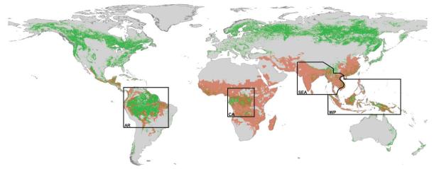
 ) overlaid on the areas of closed forests [
 ; as indicated on the Global Forest Cover map (Anon., 2001a)]. The Amazon region (AR), Central Africa (CA), South–east Asia (SEA) and the Western Pacific (WP) are roughly indicated; the sinuous limit between SEA and WP is based on the map of malaria zones developed by Macdonald (1957).
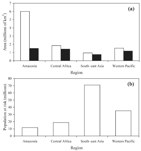
References
-
- Achard F, Eva HD, Stibig HJ, Mayaux P, Gallego J, Richards T, Malingreau JP. Determination of deforestation rates of the world’s humid tropical forests. Science. 2002;297:999–1002. - PubMed
-
- Anon . International Classification and Mapping of Vegetation. United Nations Educational, Scientific and Cultural Organization; Paris: 1973.
-
- Anon . FRA 2000 — Global Forest Cover Mapping Final Report. Food and Agriculture Organization of the United Nations; Rome: 2001a.
-
- Anon . Global Forest Resources Assessment 2000 — Main Report. Food and Agriculture Organization of the United Nations; Rome: 2001b.
-
- Anon . Ecosystems and Human Well-being: Synthesis. World Resources Institute; Washington, DC: 2005.
Publication types
MeSH terms
Grants and funding
LinkOut - more resources
Full Text Sources
Medical