Review
. 2006:62:221-61.
doi: 10.1016/S0065-308X(05)62007-6.

Global epidemiology, ecology and control of soil-transmitted helminth infections

Affiliations
Review

Global epidemiology, ecology and control of soil-transmitted helminth infections

S Brooker et al. Adv Parasitol. 2006.

Abstract

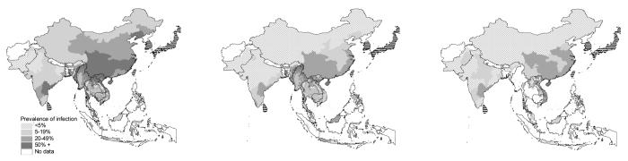
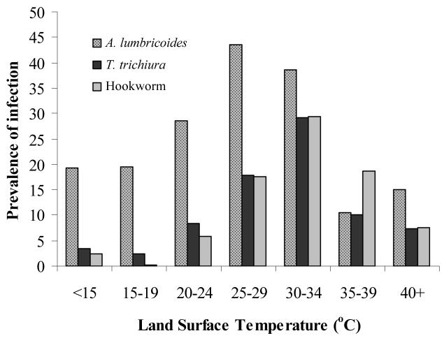
Soil-transmitted helminth (STH) infections are among the most prevalent of chronic human infections worldwide. Based on the demonstrable impact on child development, there is a global commitment to finance and implement control strategies with a focus on school-based chemotherapy programmes. The major obstacle to the implementation of cost-effective control is the lack of accurate descriptions of the geographical distribution of infection. In recent years, considerable progress has been made in the use of geographical information systems (GIS) and remote sensing (RS) to better understand helminth ecology and epidemiology, and to develop low-cost ways to identify target populations for treatment. This review explores how this information has been used practically to guide large-scale control programmes. The use of satellite-derived environmental data has yielded new insights into the ecology of infection at a geographical scale that has proven impossible to address using more traditional approaches, and has in turn allowed spatial distributions of infection prevalence to be predicted robustly by statistical approaches. GIS/RS have increasingly been used in the context of large-scale helminth control programmes, including not only STH infections but also those focusing on schistosomiasis, filariasis and onchocerciasis. The experience indicates that GIS/RS provides a cost-effective approach to designing and monitoring programmes at realistic scales. Importantly, the use of this approach has begun to transition from being a specialist approach of international vertical programmes to becoming a routine tool in developing public sector control programmes. GIS/RS is used here to describe the global distribution of STH infections and to estimate the number of infections in school-age children in sub-Saharan Africa (89.9 million) and the annual cost of providing a single anthelmintic treatment using a school-based approach (US$5.0-7.6 million). These are the first estimates at a continental scale to explicitly include the fine spatial distribution of infection prevalence and population, and suggest that traditional methods have overestimated the situation. The results suggest that continent-wide control of parasites is, from a financial perspective, an attainable goal.


Figures

Figure 1
Figure 1
Relationship between temperature (a) parasite survival and (b) development duration. Points indicate experimental data (Seamster, 1950; Beer, 1973; Nwosu, 1978; Udonsi & Atata, 1987) and lines are fits derived from fractional polynomials analyses. Regression details: parasite survival y = 0.884 + −22.88x−0.5 + −7.73ln(x); A. lumbricoides duration y = 8.601 + −63.718x− −2 + 2.526x−3; T. trichiura duration y = 26.079 + 41209.68x−−2 + −1715.02x—2; hookworm duration y = 3.701 + 40.88x−−2 + −46.18x−−2
Figure 2
Figure 2
Predicted prevalence of (a) A. lumbricoides, (b) T. trichiura and (c) hookworm, based on relationships between observed prevalence of infection among school-aged children (insert) and AVHRR satellite data (see Hay et al., this volume for details) and elevation obtained from an interpolated digital elevation model from the Global Land Information System (GLIS) of the United States Geological Survey (http://edcwww.cr.usgs.gov/landdaac/gtopo30/). Prevalence data are available for 1172 sites across sub-Saharan Africa including 84,412 children. All surveys were conducted using similar diagnostic techniques (direct smear, typically using the Kato-Katz method) and based on random samples of children in areas where no control measures have previously been undertaken. Due to non-linear relationships between observed prevalence and predictor variables, the predictors were categorised before being entered into the models. The coefficients from these models were then applied to the categories of the predictor variables to generate a predicted prevalence of infection. Model coefficients for A. lumbricoides included LST 29 - 32°C: −0.3 (95% CI −0.3, −0.2), LST 32 - 37.5°C: −1.7 (95% CI −1.8, −1.6), LST 37.5 - 45°C: −3.8 (95% CI −3.9, −3.7), LST >45°C: −5.1 (95% CI −5.5, −4.7), NDVI −7.8 − −6: 0.3 (95% CI −0.1, 0.6), NDVI −6 − −5: −0.02 (95% CI −0.4, 0.3), NDVI >−5: 0.4 (95% CI 0.1, 0.8), elevation 500 - 1000 m: −0.05 (95% CI −0.1, 0.01), elevation 500 - 1000m: −1.0 (95% CI −1.0, −0.9) and elevation 1000 - 1500m: −1.5 (95% CI −1.6, −1.4) and explained 28.2% of the variance of the data (R2=0.282); for T. trichiura they included LST 29 - 32°C: −0.6 (95% CI −0.7, −0.5), LST 32 - 37.5°C: −2.2 (95% CI −2.3, −2.1), LST 37.5 - 45°C: −4.2 (95% CI −4.4, −4.1), LST >45°C: −6.0 (95% CI −6.3, −5.7), NDVI −7.8 − −6: −1.5 (95% CI −1.7, −1.4), NDVI −6 − −5: −1.6 (95% CI −1.8, −1.4), NDVI >−5: −1.2 (95% CI −1.4, −1.0), elevation 500 - 1000 m: −0.1 (95% CI −0.2, −0.1), elevation 1000 - 1500m: −1.3 (95% CI −1.3, −1.2) and elevation >1500m: −2.4 (95% CI −2.6, −2.3) (R2=0.335) and for hookworm they included LST 29 - 32°C: 0.02 (95% CI −0.1, 0.1), LST 32 - 37.5°C: 0.8 (95% CI 0.7, 0.8), LST 37.5 - 45°C: 0.9 (95% CI 0.8, 1.0), LST >45°C: −0.1 (95% CI −0.2, 0.1), NDVI −7.8 − −6: 1.3 (95% CI 1.1, 1.4), NDVI −6 − −5: 1.9 (95% CI 1.8, 2.1), NDVI >−5: 2.4 (95% CI 2.2, 2.5), elevation 500 - 1000 m: −0.5 (95% CI −0.6, −0.5), elevation 1000 - 1500m: 0.4 (95% CI 0.3, 0.4) and elevation >1500m: −0.7 (95% CI −0.8, −0.6) (R2=0.071). Validation statistics including area under the curve (AUC), optimal prediction threshold and sensitivity, specificity, positive predictive value (PPV), and negative predictive value (NPV) at the optimal prediction threshold are presented for observed prevalence thresholds of 5% and 50%.
Figure 3
Figure 3
Relationship between mean Land Surface Temperature, estimated from satellite data, and prevalence of STH infection. Estimates are derived for each survey location and locations with the same degree Celsius are averaged for presentation. (see legend of Figure 2 for details.)
Figure 4
Figure 4
Relationship between number of day which temperature <40 °C, which is suitable for survival of free-living STH infective stages, and proportion infected based on observed data for 601 locations from nationwide surveys in Cameroon (Ratard et al., 1991, 1992), Chad (Brooker et al. 2002a), and Uganda (Brooker et al., 2004b). Data were collected in cross-sectional school surveys using similar diagnostic technique (Kato-Katz method) and sampling designs (stratified, random), and encompass a broad range of infection rates. Insert: Relationship between mean LST and number of weeks temperature falls below 40 °C (y= −3.006x + 147.8, r=0.94, p<0.001). Estimates were derived for each survey location and locations with the same number of days under the thermal threshold were averaged for presentation.
Figure 5
Figure 5
Distribution of S. mansoni in Uganda and classification of the country according to treatment category: (1) mass treatment without further surveys, <5km from Lake Victoria and Lake Albert (not shown); (2) non-treatment areas, altitude >1400 m or annual rainfall <850 mm (grey areas); (3) and areas requiring further investigation using LQAS (white areas). For further details see Kabatereine et al. (2004), Brooker et al. (2004a, 2005).
Figure 6
Figure 6
(a) Risk prediction surface for prevalence of S. haematobium infection in northwest Tanzania. Values presented are interpolated median posterior risk estimates from a Bayesian geostatistical binomial logistic regression model. Model parameters were: α (intercept) = 2.3 (95% Bayesian CI −0.7 - 5.9), κ (smoothing parameter) = 0.9 (95% Bayesian CI 0.6 - 1.2), ϕ (decay of spatial correlation) = 0.2 (95% Bayesian CI 0.1 - 0.5) and σ (overall variance) = 4.8 (95% Bayesian CI 2.7 - 7.6). (b) Risk prediction surface for prevalence of S. mansoni infection in northwest Tanzania. Values presented are interpolated median posterior risk estimates from the Bayesian geostatistical binomial logistic regression model. Model parameters were: α (intercept) = −12.3 (95% Bayesian CI −18.8 − −4.5), coefficient for distance to perennial water body, <0.04 decimal degrees = 4.1 (95% Bayesian CI 2.8 - 5.4), coefficient for distance to perennial water body, 0.04 – 0.1 decimal degrees = 2.3 (95% Bayesian CI 1.2 - 3.4), coefficient for distance to perennial water body, 0.1 - 0.4 decimal degrees = 1.1 (95% Bayesian CI 0.1 −2.0), coefficient for annual minimum temperature = 0.4 (95% Bayesian CI 0.0 - 0.8), κ (smoothing parameter) = 0.8 (95% Bayesian CI 0.5 - 1.3) = ϕ (decay of spatial correlation) = 2.8 (95% Bayesian CI 1.0 - 5.7) and σ (overall variance) = 1.2 (95% Bayesian CI 0.8 - 1.9). (c) Intervention contour map overlying districts of northwest Tanzania. Areas outside the 0.1 risk contour will be excluded from the mass treatment programme and praziquantel will be made available in health centres. Areas between the 0.1 and 0.5 risk contour will receive mass treatment, targeted at school-age children. Areas within the 0.5 risk contour are priority areas where mass treatment will be targeted at school-age children and other high-risk groups.
Figure 7
Figure 7
Prevalence of STH infection by province in Asia. (a) A. lumbricoides, (b) T. trichiura and (c) hookworm. Horizontal hatched areas indicate areas where sustained control has resulted in prevalence levels of <5%; white areas indicate a lack of data. Data were derived by published surveys or reviews: Afghanistan (Albis Gabrielli, unpublished data), Bangladesh (Hall & Nahar, 1994; Mascie-Taylor et al., 1999), Bhutan (Allen et al., 2004), Cambodia (Sinuon et al., 2003; Urbani et al., 2001), China (Xu et al., 1995), India (de Silva et al., 2003), Indonesia (Margono, 2001), Lao PDR (Rim et al., 2003), Malaysia (Singh & Cox-Singh, 2001) Myanmar (Montresor et al., 2004), Pakistan (Government of Pakistan, 1988), Thailand (Anantaphruti et al 2000, 2002, 2004; Chongsuvivatwong et al 1994; Kasuya et al 1989; Nacher et al 2002; Waikagul et al 2002), Pacific Islands (Hughes et al., 2004); Vietnam (Anon 1995; van der Hoek et al. 2003). In Cambodia and Myanmar, where empirical data are lacking, prevalence of A. lumbricoides and T. trichiura is estimated from RS-based prediction models (Brooker et al., 2003).
Figure 8
Figure 8
The relationship between prevalence of STH infection in Asia and satellite-derived mean land surface temperature for 1982-1998, obtained from NOAA's AVHRR. Prevalence is expressed as median prevalence for each temperature category and the median temperature was calculated for each geographical region; it is recognized that this approach masks the heterogeneity in STH prevalence and temperature within regions, but epidemiological data are available are not available at finer spatial resolution.

References

    1. Addiss DG, Rheingans R, Twum-Danso NA, Richards FO. A framework for decision-making for mass distribution of Mectizan in areas endemic of Loa loa. Filaria Journal. 2003;2(Suppl. 1):S9. - PMC - PubMed
    1. Albonico M, Chwaya HM, Montresor A, Stolfzfus RJ, Tielsch JM, Alawi KS, Savioli L. Parasitic infections in Pemba Island school children. East African Medical Journal. 1997;74:294–298. - PMC - PubMed
    1. Allen H, Sithey G, Padmasiri EA, Montresor A. Epidemiology of soil-transmitted helminths in the western region of Bhutan. Southeast Asian Journal of Tropical Medicine and Public Health. 2004;35:1–3. - PMC - PubMed
    1. Alexander ND, Moyeed RA, Hyun PJ, Dimber ZB, Bockarie MJ, Stander J, Grenfell BT, Kazura JW, Alpers MP. Spatial variation of Anopheles-transmitted Wuchereria bancrofti and Plasmodium falciparum infection densities in Papua New Guinea. Filaria Journal. 2003;2:14. - PMC - PubMed
    1. Anon . Report of the National Anemia and Nutrition Risk Factor Survey Vietnam 1995. Hanoi: UNICEF; 1995.

Publication types

LinkOut - more resources