

Comment
doi: 10.1073/pnas.0606804103.
Epub 2006 Sep 19.
Mapping land use of tropical regions from space
Affiliations
- PMID: 16985002
- PMCID: PMC1599950
- DOI: 10.1073/pnas.0606804103
Item in Clipboard
Comment
Mapping land use of tropical regions from space
Proc Natl Acad Sci U S A.
.
No abstract available
Conflict of interest statement
The author declares no conflict of interest.
Figures
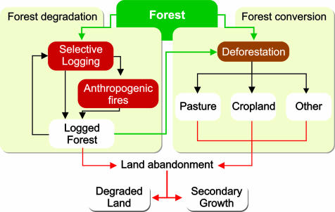
Processes that lead to forest degradation and forest conversion in the Brazilian Amazon. Remote-sensing techniques were available for mapping deforestation and forest degradation, but until the work by Morton et al. (7), little was known about land use after deforestation in large areas of Amazon region. Land abandonment could also be monitored with this new remote-sensing methodology.
Comment on
-
Cropland expansion changes deforestation dynamics in the southern Brazilian Amazon.Proc Natl Acad Sci U S A. 2006 Sep 26;103(39):14637-41. doi: 10.1073/pnas.0606377103. Epub 2006 Sep 14. Proc Natl Acad Sci U S A. 2006. PMID: 16973742 Free PMC article.
References
-
- Fearnside PM. Conserv Biol. 2005;19:680–688.
-
- Da Silva JMC, Rylands AB, Da Fonseca GAB. Conserv Biol. 2005;19:689–694.
-
- Santilli MR, Moutinho P, Schwartzman S, Nepstad D, Curran L, Nobre C. Clim Change. 2005;71:267–276.
-
- Roberts DA, Numata I, Holmes K, Batista G, Krug T, Monteiro A, Powell B, Chadwick OA. J Geophys Res Atmos. 2002;107:8073.
-
- Rignot E, Salas WA, Skole DL. Remote Sens Environ. 1997;59:167–179.
Publication types
MeSH terms
LinkOut - more resources
Full Text Sources
