doi: 10.1128/AEM.01305-06.
Epub 2006 Oct 6.
Bacterial community structure in the hyperarid core of the Atacama Desert, Chile
Affiliations
- PMID: 17028238
- PMCID: PMC1694221
- DOI: 10.1128/AEM.01305-06
Item in Clipboard
Bacterial community structure in the hyperarid core of the Atacama Desert, Chile
Appl Environ Microbiol.
2006 Dec.
Abstract
Soils from the hyperarid Atacama Desert of northern Chile were sampled along an east-west elevational transect (23.75 to 24.70 degrees S) through the driest sector to compare the relative structure of bacterial communities. Analysis of denaturing gradient gel electrophoresis (DGGE) profiles from each of the samples revealed that microbial communities from the extreme hyperarid core of the desert clustered separately from all of the remaining communities. Bands sequenced from DGGE profiles of two samples taken at a 22-month interval from this core region revealed the presence of similar populations dominated by bacteria from the Gemmatimonadetes and Planctomycetes phyla.
Figures
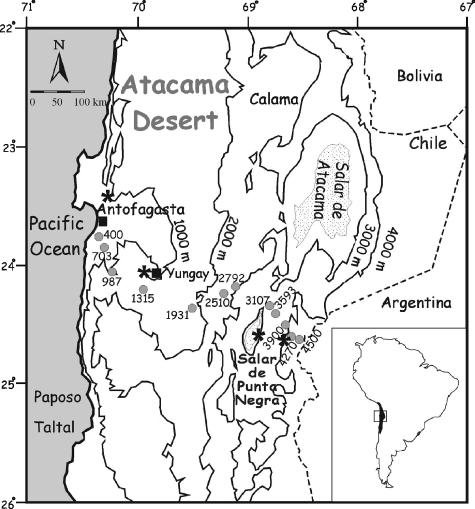
Map of the study area indicating the locations of sampling sites along the Punta Negra transect. Filled circles (•) indicate sampling sites, filled squares (▪) represent towns along the transect, and asterisks (*) indicate locations of the following four weather stations along the transect: Antofagasta (23.41°S, 70.25°W; 10-m elevation; MAT = 17°C; MAP = 2.0 mm) (28), Yungay (24.08°S, 69.97°W; 950-m elevation; MAT = 16.5°C; MAP = 0.6 mm) (29), Salar Punta Negra (24.6°S, 68.92°W; 3,000-m elevation; MAT = 7°C; MAP = 7 mm) (24), and Llullaillaco (24.63°S, 68.67°W; 4,200-m elevation; MAT = 1.7°C; MAP = 35.7 mm) (24). Throughout the Central Atacama desert, MATs decrease linearly with increasing elevation beginning at 17°C (y = −0.0038 + 18.9; r2 = 0.94).
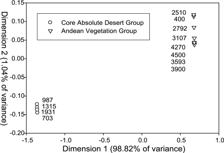
KIMDSA of the DGGE profiles from the Punta Negra transect analyzed in three dimensions with 99.35% of the variance explained, a stress factor of 0.0344, and a P value of 0.04. Analysis was done using the statistical software package R (R Foundation for Statistical Computing, Vienna, Austria). The permutation test used confirmed the significance of the classification of the groups established by KIMDSA.
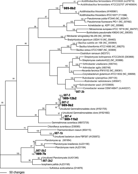
One of seven most parsimonious trees generated from reference bacterial strain sequences (GenBank) and DGGE band sequences from 987-m (boldface italic type) and 989-m (boldface type) soil samples. A base tree was generated with nearly full-length sequences from the GenBank database using maximum parsimony analysis by heuristic search using tree bisection reconnection branch swapping on starting trees generated by random sequence addition as implemented by using PAUP 4.0 Beta 10 (34). DGGE band sequences were inserted individually into the base tree data set without realignment of base tree sequences. Sulfolobus acidocaldarius was used as the outgroup. Bootstrap values (1,000 replicates) from maximum parsimony analysis are given for nodes with ≥50% support.
References
-
- Altschul, S. F., W. Gish, W. Miller, E. W. Myers, and D. J. Lipman. 1990. Basic local alignment search tool. J. Mol. Biol. 215:403-410. - PubMed
-
- Arroyo, M. T. K., C. Castor, C. Marticorena, M. Muñoz, L. Cavieres, O. Mathei, F. Squeo, M. Grosjean, and R. Rodríguez. 1998. The flora of Llullaillaco National Park located in the transitional winter-summer rainfall area of the northern Chilean Andes. Gayana Botánica 55:93-110.
-
- Ausubel, F. M., R. Brent, R. E. Kingston, D. D. Moore, J. G. Seidman, J. A. Smith, and K. Struhl (ed.). 1995. Current protocols in molecular biology, p. 2.7.3-2.7.6. John Wiley & Sons, Inc., Hoboken, N.J.
-
- Betancourt, J. L., C. Latorre, J. A. Rech, J. Quade, and K. A. Rylander. 2000. A 22,000-year record of monsoonal precipitation from northern Chile's Atacama Desert. Science 289:1542-1546. - PubMed
-
- Chanal, A., V. Chapon, K. Benserara, M. Barakat, R. Christen, W. Achouak, F. Barras, and T. Heulin. 2006. The desert of Tataouine: an extreme environment that hosts a wide diversity of microorganisms and radiotolerant bacteria. Environ. Microbiol. 8:514-525. - PubMed
Publication types
MeSH terms
Substances
Associated data
- Actions
- Actions
- Actions
- Actions
- Actions
- Actions
- Actions
- Actions
- Actions
- Actions
- Actions
Grants and funding
LinkOut - more resources
Full Text Sources
Molecular Biology Databases