. 2007 Nov 29;362(1487):2169-81.
doi: 10.1098/rstb.2007.2109.

Successful foraging zones of southern elephant seals from the Kerguelen Islands in relation to oceanographic conditions

Affiliations

Successful foraging zones of southern elephant seals from the Kerguelen Islands in relation to oceanographic conditions

Frédéric Bailleul et al. Philos Trans R Soc Lond B Biol Sci. .

Abstract

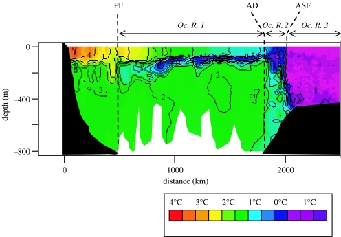
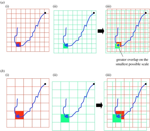
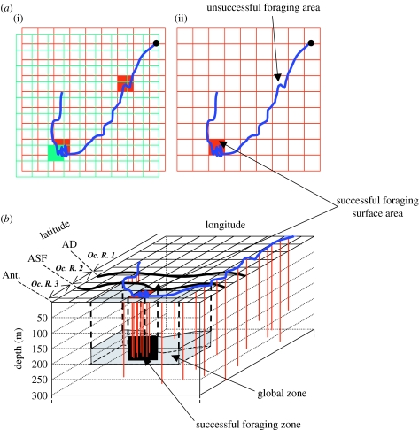
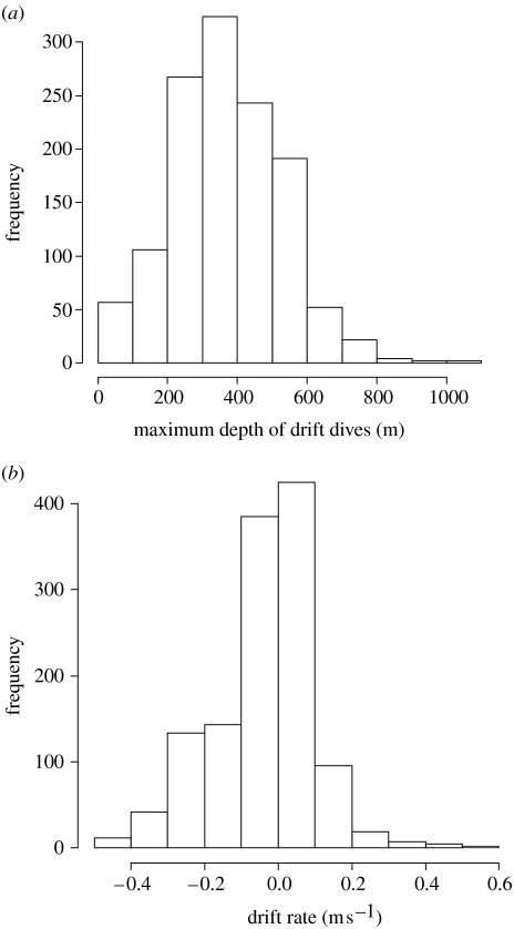
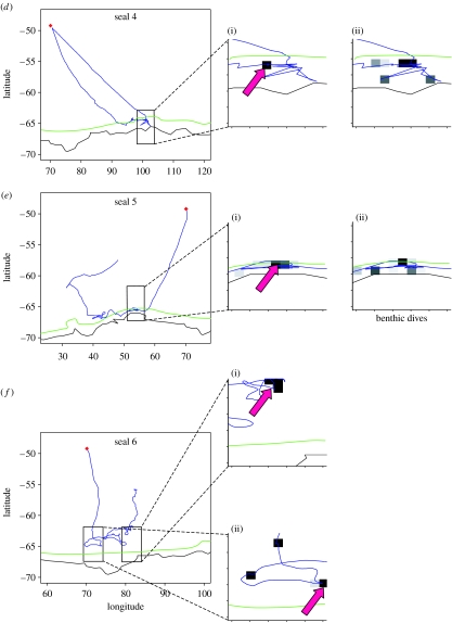
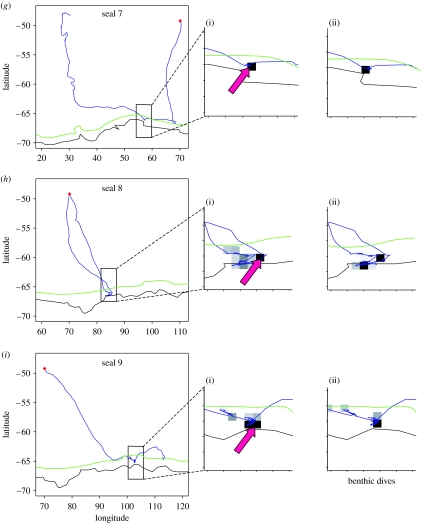
Southern elephant seals, Mirounga leonina, undertake large-scale oceanic movements to access favourable foraging areas. Successful foraging areas of elephant seals from the Kerguelen Islands are investigated here in relation to oceanographic parameters. Movements and diving activity of the seals as well as oceanographic data were collected through a new generation of satellite relayed devices measuring and transmitting locations, pressure, temperature and salinity. For the first time, we have associated foraging behaviour, determined by high increased sinuosity in tracks, and dive density (i.e. number of dives performed per kilometre covered), and changes in body condition, determined by variations in drift rate obtained from drift dives, to identify the oceanographic conditions of successful foraging zones for this species. Two main sectors, one close to the Antarctic continent and the other along the Polar Front (PF), where both foraging activity and body condition increase, seem to be of particular interest for the seals. Within these regions, some seals tended to focus their foraging activity on zones with particular temperature signatures. Along the Antarctic continent, some seals targeted colder waters on the sea bottom during benthic dives, while at the PF the favourable zones tended to be warmer. The possible negative effect of colder waters in Antarctic on the swimming performances of potential fish or squid prey could explain the behaviour of elephant seals in these zones, while warmer waters within the PF could correspond to the optimal conditions for potential myctophid prey of elephant seals.


Figures

Figure 1
Figure 1
Vertical temperature section obtained for one individual between Kerguelen and Antarctica. Position of the hydrological fronts is represented (PF, Polar Front; AD, Antarctic Divergence; ASF, Antarctic Slope Front). The fronts delimit three different oceanographic regions (Oc. R.).
Figure 2
Figure 2
Representation of the methodology used to determine the scale (a, scale 1; b, scale 2) for which successful foraging zones are described more precisely. A hypothetical track is represented in blue. Kerguelen is represented by the black dot. (i) Selection of the sectors where the foraging searching activity is most intensive (red area). (ii) Selection of the sectors where the drift rates increased (green area). (iii) Superimposition of the grids and determination of greatest overlap on the smallest possible scale. In this example, the scale 1 is selected.
Figure 3
Figure 3
Representation of the methodology used to determine successful foraging zone. (a) The successful foraging surface areas were defined as the sectors where the foraging searching activity was most intensive (red area), only when these sectors were partially or entirely associated with a sector where the drift rates increased (green area). (b) Within successful surface areas identified, the water layer where the mean maximum depth of dives occurred was determined. The successful foraging zones were thus defined in three dimensions. A hypothetical track is represented in blue. Diving activity is represented by red strokes. AD, Antarctic Divergence; ASF, Antarctic Slope Front; Ant., Antarctica; Oc. R., oceanographic region.
Figure 4
Figure 4
(a) Histogram of the maximum depth of drift dives. (b) Histogram of the drift rates.
Figure 5
Figure 5
Movements of 10 post-moulting elephant seals (aj) tracked from Kerguelen Islands (blue). Enlarged sectors focus on the portion of tracks where foraging searching activity is greatest. (i) Red arrows focus on successful foraging surface areas. (ii) Intensive benthic activity is represented by dark square. Position of the Kerguelen Islands is marked by a red dot. The border of the Antarctic continent is represented by a black line. The limit of the Antarctic shelf (isobath 500 m) is represented by a green line.
Figure 5
Figure 5
Movements of 10 post-moulting elephant seals (aj) tracked from Kerguelen Islands (blue). Enlarged sectors focus on the portion of tracks where foraging searching activity is greatest. (i) Red arrows focus on successful foraging surface areas. (ii) Intensive benthic activity is represented by dark square. Position of the Kerguelen Islands is marked by a red dot. The border of the Antarctic continent is represented by a black line. The limit of the Antarctic shelf (isobath 500 m) is represented by a green line.

References

    1. Bailleul F, Charrassin J.-B, Ezraty R, Girard-Ardhuin F, McMahon C.R, Field I.C, Guinet C. Southern elephant seals from Kerguelen Islands confronted by Antarctic sea ice. Changes in movements and in diving behaviour. Deep Sea Res. II. 2007;54:343–355. doi:10.1016/j.dsr2.2006.11.005 - DOI
    1. Belkin I.G, Gordon A.L. Southern Ocean fronts from the Greenwich meridian to Tasmania. J. Geophys. Res. 1996;101:3675–3696. doi:10.1029/95JC02750 - DOI
    1. Biuw M, McConnell B.J, Bradshaw C.J.A, Burton H.R, Fedak M.A. Blubber and buoyancy: monitoring the body condition of free-ranging seals using simple dive characteristics. J. Exp. Biol. 2003;206:3405–3423. doi:10.1242/jeb.00583 - DOI - PubMed
    1. Bonadonna F, Lea M.A, Dehorter O, Guinet C. Foraging ground fidelity and route-choice tactics of a marine predator: the Antarctic fur seal Arctocephalus gazella. Mar. Ecol. Prog. Ser. 2001;223:287–297.
    1. Bornemann H, Kreyscher M, Ramdohr S, Martin T, Carlini A, Sellmann L, Plötz J. Southern elephant seal movements and Antarctic sea ice. Antarct. Sci. 2000;12:3–15.

Publication types