

Crossing the final ecological threshold in high Arctic ponds
- PMID: 17606917
- PMCID: PMC1941480
- DOI: 10.1073/pnas.0702777104
Crossing the final ecological threshold in high Arctic ponds
Abstract
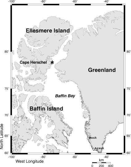
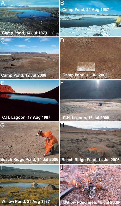
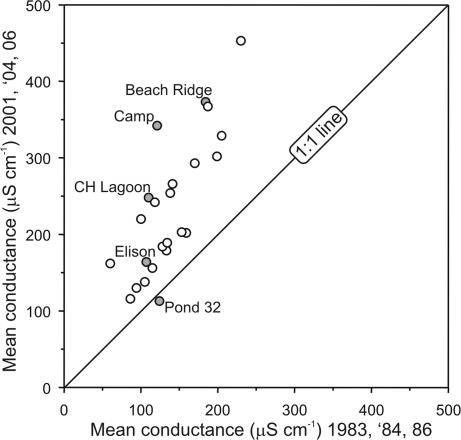
A characteristic feature of most Arctic regions is the many shallow ponds that dot the landscape. These surface waters are often hotspots of biodiversity and production for microorganisms, plants, and animals in this otherwise extreme terrestrial environment. However, shallow ponds are also especially susceptible to the effects of climatic changes because of their relatively low water volumes and high surface area to depth ratios. Here, we describe our findings that some high Arctic ponds, which paleolimnological data indicate have been permanent water bodies for millennia, are now completely drying during the polar summer. By comparing recent pond water specific conductance values to similar measurements made in the 1980s, we link the disappearance of the ponds to increased evaporation/precipitation ratios, probably associated with climatic warming. The final ecological threshold for these aquatic ecosystems has now been crossed: complete desiccation.
Conflict of interest statement
The authors declare no conflict of interest.
Figures
Similar articles
-
Climate-driven regime shifts in the biological communities of arctic lakes.Proc Natl Acad Sci U S A. 2005 Mar 22;102(12):4397-402. doi: 10.1073/pnas.0500245102. Epub 2005 Feb 28. Proc Natl Acad Sci U S A. 2005. PMID: 15738395 Free PMC article.
-
Acidic, neutral and alkaline forest ponds as a landscape element affecting the biodiversity of freshwater snails.Naturwissenschaften. 2017 Aug 22;104(9-10):73. doi: 10.1007/s00114-017-1495-z. Naturwissenschaften. 2017. PMID: 28831513 Free PMC article.
-
Farm ponds make a contribution to the biodiversity of aquatic insects in a French agricultural landscape.C R Biol. 2008 Apr;331(4):298-308. doi: 10.1016/j.crvi.2008.01.009. Epub 2008 Mar 4. C R Biol. 2008. PMID: 18355753
-
Ecological dynamics across the Arctic associated with recent climate change.Science. 2009 Sep 11;325(5946):1355-8. doi: 10.1126/science.1173113. Science. 2009. PMID: 19745143 Review.
-
Levels and trends of poly- and perfluorinated compounds in the arctic environment.Sci Total Environ. 2010 Jul 1;408(15):2936-65. doi: 10.1016/j.scitotenv.2010.03.015. Epub 2010 May 20. Sci Total Environ. 2010. PMID: 20493516 Review.
Cited by
-
Diversity and Composition of Bacterial Community in Soils and Lake Sediments from an Arctic Lake Area.Front Microbiol. 2016 Jul 28;7:1170. doi: 10.3389/fmicb.2016.01170. eCollection 2016. Front Microbiol. 2016. PMID: 27516761 Free PMC article.
-
Multiple drivers of ecological change in Arctic lakes and ponds.PLoS One. 2021 Jul 30;16(7):e0254257. doi: 10.1371/journal.pone.0254257. eCollection 2021. PLoS One. 2021. PMID: 34330143 Free PMC article.
-
Broad-scale lake expansion and flooding inundates essential wood bison habitat.Nat Commun. 2017 Feb 23;8:14510. doi: 10.1038/ncomms14510. Nat Commun. 2017. PMID: 28230049 Free PMC article.
-
Modeling Spatial and Temporal Variation in Natural Background Specific Conductivity.Environ Sci Technol. 2019 Apr 16;53(8):4316-4325. doi: 10.1021/acs.est.8b06777. Epub 2019 Apr 1. Environ Sci Technol. 2019. PMID: 30860824 Free PMC article.
-
Arctic lake physical processes and regimes with implications for winter water availability and management in the National Petroleum Reserve Alaska.Environ Manage. 2009 Jun;43(6):1071-84. doi: 10.1007/s00267-008-9241-0. Epub 2008 Dec 20. Environ Manage. 2009. PMID: 19101761
References
-
- Arctic Climate Impact Assessment. Impacts of a Warming Arctic: Arctic Climate Impact Assessment. Cambridge, UK: Cambridge Univ Press; 2004.
-
- Douglas MSV, Smol JP. Arch Hydrobiologie. 1994;131:401–434.
-
- Douglas MSV, Smol JP, Blake W., Jr Bull Geol Surv Can. 2000;529:257–269.
-
- Douglas MSV, Smol JP, Blake W., Jr Science. 1994;266:416–419. - PubMed
-
- Quinlan R, Douglas MSV, Smol JP. Global Change Biology. 2005;11:1381–1386.
Publication types
MeSH terms
LinkOut - more resources
Full Text Sources
Other Literature Sources
