

Assessing uncertainty in spatial exposure models for air pollution health effects assessment
- PMID: 17687440
- PMCID: PMC1940074
- DOI: 10.1289/ehp.9849
Assessing uncertainty in spatial exposure models for air pollution health effects assessment
Abstract
Background: Although numerous epidemiologic studies now use models of intraurban exposure, there has been little systematic evaluation of the performance of different models.
Objectives: In this present article we proposed a modeling framework for assessing exposure model performance and the role of spatial autocorrelation in the estimation of health effects.
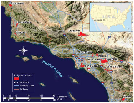
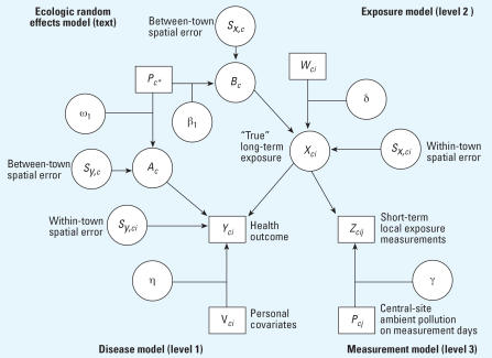
Methods: We obtained data from an exposure measurement substudy of subjects from the Southern California Children's Health Study. We examined how the addition of spatial correlations to a previously described unified exposure and health outcome modeling framework affects estimates of exposure-response relationships using the substudy data. The methods proposed build upon the previous work, which developed measurement-error techniques to estimate long-term nitrogen dioxide exposure and its effect on lung function in children. In this present article, we further develop these methods by introducing between- and within-community spatial autocorrelation error terms to evaluate effects of air pollution on forced vital capacity. The analytical methods developed are set in a Bayesian framework where multistage models are fitted jointly, properly incorporating parameter estimation uncertainty at all levels of the modeling process.
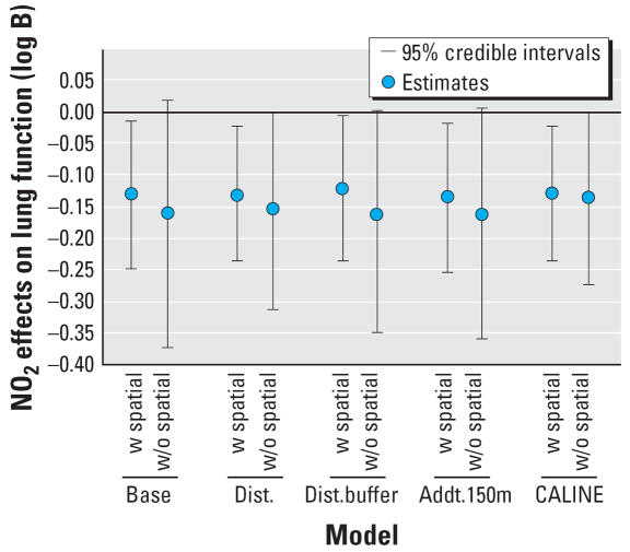
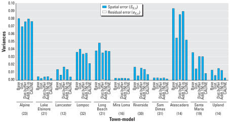
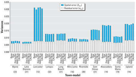
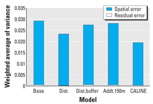
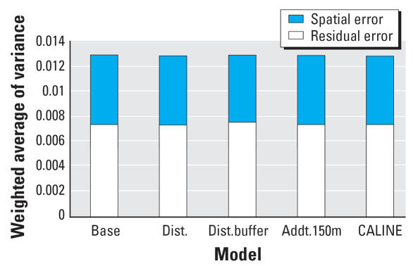
Results: Results suggest that the inclusion of residual spatial error terms improves the prediction of adverse health effects. These findings also demonstrate how residual spatial error may be used as a diagnostic for comparing exposure model performance.
Figures
References
-
- Ackermann-Liebrich U, Leuenberger P, Schwartz J, Schindler C, Monn C, Bolognini G, et al. Lung function and long term exposure to air pollutants in Switzerland. Study on Air Pollution and Lung Diseases in Adults (SAPALDIA) Team. Am J Respir Crit Care Med. 1997;155(1):122–129. - PubMed
-
- Akaike H. Information theory and an extension of the maximum likelihood principle. In: Petrov BN, Cs′aki F, editors. Proceedings of the Second International Symposium on Information Theory. Budapest: Akad′emiai Kiado; 1973. pp. 267–281.
-
- Benson P. CALINE4—a Dispersion Model for Predicting Air Pollution Concentration near Roadways. Sacramento, CA: Office of Transportation Laboratory, California Department of Transportation.; 1984.
-
- Besag J, York J, Mollie A. Bayesian image restoration, with two applications in spatial statistics. Ann Inst Stat Math. 1991;43(1):1–59.
-
- Borgoni R, Billari FC. Bayesian spatial analysis of demographic survey data. Demographic Res. 2003;8(3):61–92.