Use of geographic information systems for planning HIV prevention interventions for high-risk youths
- PMID: 17901452
- PMCID: PMC2040351
- DOI: 10.2105/AJPH.2005.076851
Use of geographic information systems for planning HIV prevention interventions for high-risk youths
Abstract
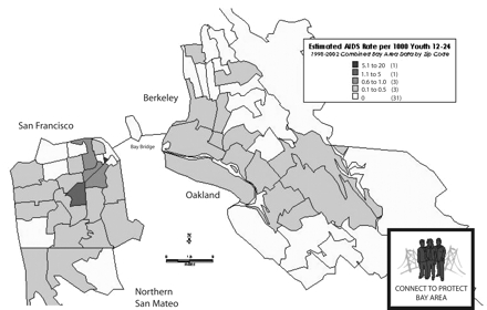
Geographic information system (GIS) analysis is an emerging tool for public health intervention planning. Connect to Protect, a researcher-community collaboration working in 15 cities to reduce HIV infection among youths, developed GIS databases of local health, crime, and demographic data to evaluate the geographic epidemiology of sexually transmitted infections and HIV risk among adolescents. We describe the process and problems of data acquisition, analysis, and mapping in the development of structural interventions, demonstrating how program planners can use this technology to inform and improve planning decisions. The Connect to Protect project's experience suggests strategies for incorporating public data and GIS technology into the next generation of public health interventions.
Figures
References
-
- HIV/AIDS Surveillance Report, 2004. Atlanta, Ga: Centers for Disease Control and Prevention; 2005.
-
- Thomas JC, Clark M, Robinson J, Monnett M, Kilmarx PH, Peterman TA. The social ecology of syphilis. Soc Sci Med. 1999;48:1081–1094. - PubMed
-
- Aral SO, Holmes KK, Padian NS, Cates W Jr. Overview: individual and population approaches to the epidemiology and prevention of sexually transmitted diseases and human immunodeficiency virus infection. J Infect Dis. 1996; 174(suppl 2):S127–S133. - PubMed
-
- Ross MW, Henry D, Freeman A, Caughy M, Dawson AG. Environmental influences on safer sex in young gay men: a situational presentation approach to measuring influence on sexual health. Arch Sex Behav. 2004;33: 249–257. - PubMed
Publication types
MeSH terms
Grants and funding
LinkOut - more resources
Full Text Sources
Medical