. 2008 Jan 25:7:20.
doi: 10.1186/1475-2875-7-20.

A tool box for operational mosquito larval control: preliminary results and early lessons from the Urban Malaria Control Programme in Dar es Salaam, Tanzania

Affiliations

A tool box for operational mosquito larval control: preliminary results and early lessons from the Urban Malaria Control Programme in Dar es Salaam, Tanzania

Ulrike Fillinger et al. Malar J. .

Abstract

Background: As the population of Africa rapidly urbanizes, large populations could be protected from malaria by controlling aquatic stages of mosquitoes if cost-effective and scalable implementation systems can be designed.

Methods: A recently initiated Urban Malaria Control Programme in Dar es Salaam delegates responsibility for routine mosquito control and surveillance to modestly-paid community members, known as Community-Owned Resource Persons (CORPs). New vector surveillance, larviciding and management systems were designed and evaluated in 15 city wards to allow timely collection, interpretation and reaction to entomologic monitoring data using practical procedures that rely on minimal technology. After one year of baseline data collection, operational larviciding with Bacillus thuringiensis var. israelensis commenced in March 2006 in three selected wards.

Results: The procedures and staff management systems described greatly improved standards of larval surveillance relative to that reported at the outset of this programme. In the first year of the programme, over 65,000 potential Anopheles habitats were surveyed by 90 CORPs on a weekly basis. Reaction times to vector surveillance at observations were one day, week and month at ward, municipal and city levels, respectively. One year of community-based larviciding reduced transmission by the primary malaria vector, Anopheles gambiae s.l., by 31% (95% C.I. = 21.6-37.6%; p = 0.04).

Conclusion: This novel management, monitoring and evaluation system for implementing routine larviciding of malaria vectors in African cities has shown considerable potential for sustained, rapidly responsive, data-driven and affordable application. Nevertheless, the true programmatic value of larviciding in urban Africa can only be established through longer-term programmes which are stably financed and allow the operational teams and management infrastructures to mature by learning from experience.


Figures
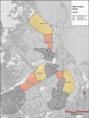
Figure 1
Figure 1
Wards included in the study area of the Dar es Salaam Urban Malaria Control Programme (UMCP), specifying those targeted for larviciding from March 2006 onwards (intervention), those considered to be the most comparable control (non-intervention wards) and those remaining.
Figure 2
Figure 2
Reporting structure of the UMCP, presented as a matrix of activities which are hierarchically layered over a range of spatial and administrative scales. The numbers presented in brackets describe the number of personnel assigned to each post in each administrative subunit rather than level (e.g. 2 municipal inspectors at each of 3 municipalities means that a total of 6 should be working for the programme at any time).
Figure 3
Figure 3
Example of a sketch map, aerial picture and field map. A. Sketch map of TCU no. 40 in Kurasini ward, Shimo la Udongo neighbourhood, as drawn by the responsible CORP. Features comprise plots with continuous numbering, streets, drains, agricultural areas and ponds. B. The same area on an aerial picture. The yellow lines connect identical features on the sketch maps and the aerial picture. C. The same area on the laminated map used in the field. The features to be mapped (TCU boundaries and numbers) were marked with non-permanent red marker pens. D. Project management team discussing over the field map of a whole ward, and deciding on necessary follow-up actions. Reproduced from Dongus et al. 2007 [28].
Figure 4
Figure 4
Examples of spot-checking forms [see Additional file 5] for Municipal Mosquito Control Inspectors. A. A typical example signed on the bottom left by a City Mosquito Surveillance Officer to show it has been checked for consistency and signs of problems requiring corrective action by management at city, municipal and ward level. B. An example of where an inspector has found poor coverage of potential habitats for Anopheles larvae by a CORP but failed to highlight it or record any corrective action. Note the query of the City Mosquito Surveillance Officer at the bottom.
Figure 5
Figure 5
Example of a completed weekly ward summary form [see Additional file 9] filled out by the Ward Supervisor and totalled along the bottom with a pocket calculator to enable rapid entry into monthly report templates at the municipal level.
Figure 6
Figure 6
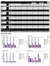
Example of a mosquito larval surveillance component in a municipal monthly report template. A. The overall data entry table in which each row corresponds to one, or occasionally two (see bottom row for example of a very large neighbourhood) folders, each containing 4 or 5 sequential weekly ward summary forms and respective sets of CORPs larval surveillance forms. Note that weeks overlapping two months are assigned to specific calendar months in advance so that each operational month has a predefined start and end date, spanning exactly 4 or 5 weeks. B. A typical automatically generated chart summarizing the observed distribution of larval habitat abundance and mosquito occupancy in one ward.
Figure 7
Figure 7
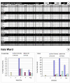
Example of a mosquito adult surveillance component in a municipal monthly report template. A. The overall data entry table (empty fields indicate missing data) B. A typical automatically generated chart summarizing the observed distribution of adult mosquitoes.
Figure 8
Figure 8
Monthly average of aquatic habitats surveyed in the three municipalities Kinondoni, Ilala and Temeke from February 2005 to March 2007 in relation to rainfall.
Figure 9
Figure 9
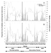
Impact of seasonal rainfall variation and larvicide application on aquatic-stage mosquito populations between April 2005 and June 2007. Larvicide application started in the intervention sites in March 2006 week number 1. A: Proportion of aquatic habitats containing late instar culicine larvae at weekly surveys. B: Proportion of aquatic habitats containing late instar anopheline larvae at weekly surveys.
Figure 10
Figure 10
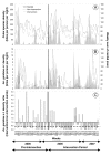
Impact of seasonal rainfall variation and larvicide application on weekly adult mosquito densities between April 2005 and June 2007. A. Rainfall and densities of adult Culex species, B. Rainfall and densities of adult Anopheles gambiae s.l., C. The ratio of densities of An. gambiae s.l. in intervention wards relative to non-intervention wards. The line representing the x-axis in panel C represents equivalence of densities in intervention and a priori selected non-intervention wards while the vertical black line represents the initiation of larviciding activities. The thick, broken horizontal line in panel C represents the ratio of exposure estimated to be provided by an insecticide-treated net in urban Dar es Salaam [26].
Figure 11
Figure 11
Proportion of habitats successfully detected (sensitivity) and correctly identified (specificity) by larval surveillance CORPs in November 2005, as determined from the random on-site spot checks of the Municipal Mosquito Control Inspectors using methodology essentially identical to earlier evaluations of larval surveillance [24].
Figure 12
Figure 12
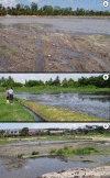
Examples of inaccessible but productive Anopheles aquatic habitats in the wards of Buguruni (A), Mikocheni (B) and Kurasini (C) during the period October to December 2006. Note that all the open soil surfaces depicted are in fact very soft mud which is impossible to walk across. Although these ponds had been freshly drained for maintenance, their low porosity, and the rainfall which immediately followed their exposure, resulted in abundant and stable surface water in multiple inaccessible depressions on the surface for two months. These areas closely resemble similarly challenging sites in flooding river valleys of West Africa which can be rigorously controlled with powered granule-blowing equipment [42].

Similar articles

Cited by

References

    1. Hay SI, Guerra CA, Tatem AJ, Atkinson PM, Snow RW. Urbanization, malaria transmission and disease burden in Africa. Nature reviews. 2005;3:81–90. doi: 10.1038/nrmicro1069. - DOI - PMC - PubMed
    1. Keiser J, Utzinger J, Caldas de Castro M, Smith TA, Tanner M, Singer BH. Urbanization in sub-saharan Africa and implication for malaria control. Am J Trop Med Hyg. 2004;71:118–127. - PubMed
    1. Robert V, Macintyre K, Keating J, Trape JF, Duchemin JB, Warren M, Beier JC. Malaria transmission in urban sub-Saharan Africa. Am J Trop Med Hyg. 2003;68:169–176. - PubMed
    1. Killeen GF. Following in Soper's footsteps: northeast Brazil 63 years after eradication of Anopheles gambiae. Lancet Infect Dis. 2003;3:663–666. doi: 10.1016/S1473-3099(03)00776-X. - DOI - PubMed
    1. Killeen GF, Fillinger U, Kiche I, Gouagna LC, Knols BG. Eradication of Anopheles gambiae from Brazil: lessons for malaria control in Africa? Lancet Infect Dis. 2002;2:618–627. doi: 10.1016/S1473-3099(02)00397-3. - DOI - PubMed

Publication types