

Addressing diarrhea prevalence in the West African Middle Belt: social and geographic dimensions in a case study for Benin
- PMID: 18433488
- PMCID: PMC2377241
- DOI: 10.1186/1476-072X-7-17
Addressing diarrhea prevalence in the West African Middle Belt: social and geographic dimensions in a case study for Benin
Abstract
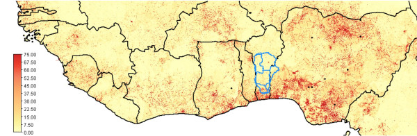
Background: In West Africa, the Northern Sahelian zone and the coastal areas are densely populated but the Middle Belt in between is in general sparsely settled. Predictions of climate change foresee more frequent drought in the north and more frequent flooding in the coastal areas, while conditions in the Middle Belt will remain moderate. Consequently, the Middle Belt might become a major area for immigration but there may be constraining factors as well, particularly with respect to water availability. As a case study, the paper looks into the capacity of the Middle Belt zone of Benin, known as the Oueme River Basin (ORB), to reduce diarrhea prevalence. In Benin it links to the Millennium Development Goals on child mortality and environmental sustainability that are currently farthest from realization. However, diarrhea prevalence is only in part due to lack of availability of drinking water from a safe source. Social factors such as hygienic practices and poor sanitation are also at play. Furthermore, we consider these factors to possess the properties of a local public good that suffers from under provision and requires collective action, as individual actions to prevent illness are bound to fail as long as others free ride.
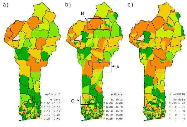
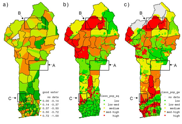
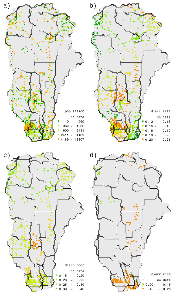
Methods: Combining data from the Demographic Health Survey with various spatial data sets for Benin, we apply mixed effect logit regression to arrive at a spatially explicit assessment of geographical and social determinants of diarrhea prevalence. Starting from an analysis of these factors separately at national level, we identify relevant proxies at household level, estimate a function with geo-referenced independent variables and apply it to evaluate the costs and impacts of improving access to good water in the basin.
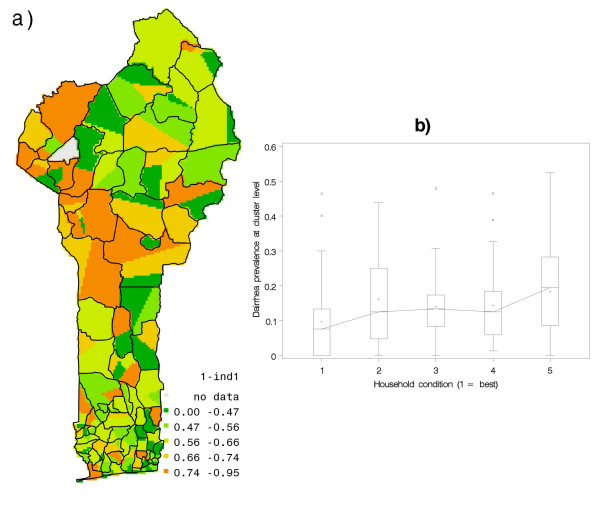
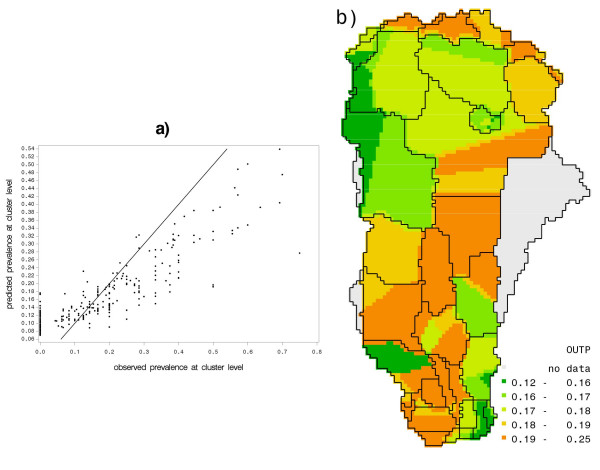
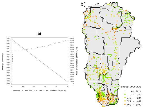
Results: First, the study confirms the well established stylized fact on the causes of diarrhea that a household with access to clean water and with good hygienic practices will, irrespective of other conditions, not suffer diarrhea very often. Second, our endogeneity tests show that joint estimation performs better than an instrumental variable regression. Third, our model is stable with respect to its functional form, as competing specifications could not achieve better performance in overall likelihood or significance of parameters. Fourth, it finds that the richer and better educated segments of the population suffer much less from the disease and apparently can secure safe water for their households, irrespective of where they live. Fifth, regarding geographical causes, it indicates that diarrhea prevalence varies with groundwater availability and quality across Benin. Finally, our assessment of costs and benefits reveals that improving physical access to safe water is not expensive but can only marginally improve the overall health situation of the basin, unless the necessary complementary measures are taken in the social sphere.
Conclusion: The ORB provides adequate water resources to accommodate future settlers but it lacks appropriate infrastructure to deliver safe water to households. Moreover, hygienic practices are often deficient. Therefore, a multifaceted approach is needed that acknowledges the public good aspects of health situation and consequently combines collective action with investments into water sources with improved management of public wells and further educational efforts to change hygienic practices.
Figures
Similar articles
-
Unraveling diarrheal disease knowledge, understanding, and management practices among climate change vulnerable coastal communities in Ghana.Front Public Health. 2024 Jun 14;12:1352275. doi: 10.3389/fpubh.2024.1352275. eCollection 2024. Front Public Health. 2024. PMID: 38947353 Free PMC article.
-
Prevalence and clustering of diarrhoea within households in India: some evidence from NFHS-4, 2015-16.J Biosoc Sci. 2021 Jan;53(1):108-120. doi: 10.1017/S0021932020000073. Epub 2020 Mar 4. J Biosoc Sci. 2021. PMID: 32127053
-
Assessment of water, sanitation, and hygiene practices and associated factors in a Buruli ulcer endemic district in Benin (West Africa).BMC Public Health. 2015 Aug 19;15:801. doi: 10.1186/s12889-015-2154-y. BMC Public Health. 2015. PMID: 26286582 Free PMC article.
-
Community health outreach program of the Chad-Cameroon petroleum development and pipeline project.Clin Occup Environ Med. 2004 Feb;4(1):9-26. doi: 10.1016/j.coem.2003.09.004. Clin Occup Environ Med. 2004. PMID: 15043361 Review.
-
Sources, pathways, and relative risks of contaminants in surface water and groundwater: a perspective prepared for the Walkerton inquiry.J Toxicol Environ Health A. 2002 Jan 11;65(1):1-142. doi: 10.1080/152873902753338572. J Toxicol Environ Health A. 2002. PMID: 11809004 Review.
Cited by
-
Water use practices, water quality, and households' diarrheal encounters in communities along the Boro-Thamalakane-Boteti river system, Northern Botswana.J Health Popul Nutr. 2015 Nov 18;33:21. doi: 10.1186/s41043-015-0031-z. J Health Popul Nutr. 2015. PMID: 26825320 Free PMC article.
-
Inappropriate Feeding Behavior: One of the Important Causes of Malnutrition in 6- to 36-Month-Old Children in Myanmar.Am J Trop Med Hyg. 2016 Sep 7;95(3):702-8. doi: 10.4269/ajtmh.16-0019. Epub 2016 Aug 1. Am J Trop Med Hyg. 2016. PMID: 27481057 Free PMC article.
-
Spatiotemporal patterns of diarrhea incidence in Ghana and the impact of meteorological and socio-demographic factors.Front Epidemiol. 2022;2:871232. doi: 10.3389/fepid.2022.871232. Epub 2022 Apr 8. Front Epidemiol. 2022. PMID: 35822109 Free PMC article.
-
Spatial variation and hot-spots of district level diarrhea incidences in Ghana: 2010-2014.BMC Public Health. 2017 Jul 3;17(1):617. doi: 10.1186/s12889-017-4541-z. BMC Public Health. 2017. PMID: 28673274 Free PMC article.
-
Climate change and population health in Africa: where are the scientists?Glob Health Action. 2009 Nov 11;2. doi: 10.3402/gha.v2i0.2065. Glob Health Action. 2009. PMID: 20052421 Free PMC article.
References
-
- Jaiyeoba IA. An assessment of soil fertility restoration under fallow in Nigerian savannah. Soil Use and Management. 1997;13:163–164. doi: 10.1111/j.1475-2743.1997.tb00579.x. - DOI
-
- Gleave MB, White HP. The West African middle belt, environmental fact or geographer's fiction. Geographical Review. 1969;59:123–139. doi: 10.2307/213085. - DOI
-
- Gonzalez P. Desertification and a shift of forest species in the West African Sahel. Climate Research. 2001;17:217–228. doi: 10.3354/cr017217. - DOI
Publication types
MeSH terms
LinkOut - more resources
Full Text Sources
Medical
Research Materials
