. 2009 Mar 10;106(10):3670-4.
doi: 10.1073/pnas.0810156106. Epub 2009 Feb 23.

Impact of deforestation in the Amazon basin on cloud climatology

Affiliations

Impact of deforestation in the Amazon basin on cloud climatology

Jingfeng Wang et al. Proc Natl Acad Sci U S A. .

Abstract

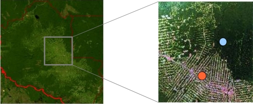
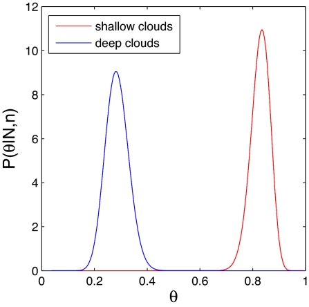
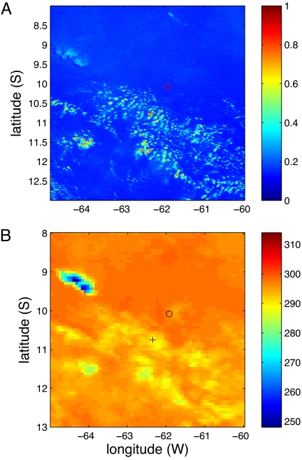
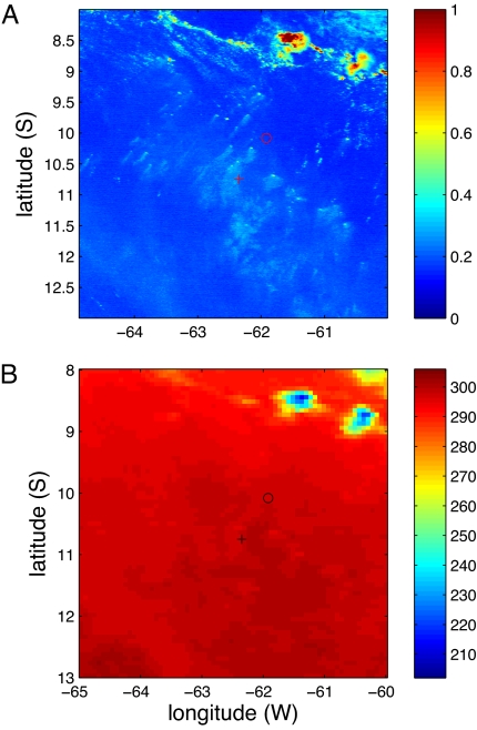
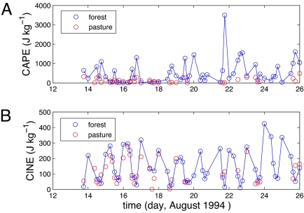
Shallow clouds are prone to appear over deforested surfaces whereas deep clouds, much less frequent than shallow clouds, favor forested surfaces. Simultaneous atmospheric soundings at forest and pasture sites during the Rondonian Boundary Layer Experiment (RBLE-3) elucidate the physical mechanisms responsible for the observed correlation between clouds and land cover. We demonstrate that the atmospheric boundary layer over the forested areas is more unstable and characterized by larger values of the convective available potential energy (CAPE) due to greater humidity than that which is found over the deforested area. The shallow convection over the deforested areas is relatively more active than the deep convection over the forested areas. This greater activity results from a stronger lifting mechanism caused by mesoscale circulations driven by deforestation-induced heterogeneities in land cover.


Conflict of interest statement

The authors declare no conflict of interest.

Figures

Fig. 1.
Fig. 1.
Study domain. The deforestation map (Left, with so-called “fish-bone” pattern highlighted in Right) for the study domain [8−13°S, 65−60°W] with the lower-left corner at [13°S, 65°W] and upper-right corner at [8°S, 60°W] in the Rondonia, Brazil (political boundary in red). The light green indicates the deforested pasture surface, and the dark green the forest. Sounding measurements were made at the forest site in Reserva Jaru [10°5′S, 61°55′W] (blue dot), and at the pasture site in Fazenda Nossa [10°45′S, 62°21′W] (orange dot) of the RBLE-3 experiment during 13–26 August 1994. The area with brownish color in the upper-right part of Left above the Rondonia boundary is a natural Savannah where an event of deep convection was observed on 25 August (see Fig. 4).
Fig. 2.
Fig. 2.
Statistical analysis. Posterior distributions of θ for shallow clouds (red) and deep clouds (blue) where n = 86 for shallow clouds and n = 29 for deep clouds with N = 103 are obtained from the monthly mean CDD data derived from cloud maps using GOES-8 visible and infrared images during 1 September 1994 to 31 March 2003.
Fig. 3.
Fig. 3.
Cloud map. GOES-7 visible (1-km pixels) and infrared (8-km pixels) (channel 8, 11.17-μm wave length) images at 19:01 UTC (local time = UTC - 4) over the study domain on 15 August 1994. a, albedo; b, brightness temperature (K). o indicates the location of soundings in the forest site; + represents the location of soundings in the pasture site of the RBLE-3 field experiment during 13–26 August 1994. Detection of shallow and deep clouds in this study is based on the combined visible and infrared images (14) as shown here.
Fig. 4.
Fig. 4.
Cloud map. GOES-7 visible and infrared images over the study domain at 18:31 UTC on 25 August 1994. a, albedo; b, brightness temperature (K). o indicates the forest site; + indicates the pasture site of the RBLE-3 field experiment during 13–26 August 1994.
Fig. 5.
Fig. 5.
Sounding data. Atmospheric instability characterized by a CAPE, and b CINE computed from the RBLE-3 radiosonde data simultaneously collected at a native forest site in Reserva Jarú and a deforested pasture site in Fazenda Nossa over the period of 13–26 August 1994.

References

    1. Gash JHC, Nobre CA, Roberts JM, Victoria RL. In: Amazonian Deforestation And Climate. Gash JHC, Nobre CA, Roberts JM, Reynaldo L, editors. Oxford Univ Press; 1996. pp. 1–14.
    1. Baidya-Roy S, Avissar R. Impact of land use/land cover change on regional hydrometeorology in Amazonia. J Geophys Res. 2002;88(D20):8037.
    1. Chu P-S, Yu Z-P, Hastenrath S. Detecting climate change concurrent with deforestation in the Amazon basin: Which way has it gone? Bull Amer Meteorol Soc. 1994;75:579–583.
    1. Durieux L, Machado LAT, Laurent H. The Impact of deforestation on cloud cover over the Amazon arc of deforestation. Remote Sen Environ. 2003;86:132–140.
    1. Negri AJ, Adler RF, Xu L, Surrat J. The impact of Amazonian deforestation on dry season rainfall. J Climate. 2004;17:1306–1319.

Publication types

LinkOut - more resources