

Risk maps of Lassa fever in West Africa
- PMID: 19255625
- PMCID: PMC2644764
- DOI: 10.1371/journal.pntd.0000388
Risk maps of Lassa fever in West Africa
Abstract
Background: Lassa fever is caused by a viral haemorrhagic arenavirus that affects two to three million people in West Africa, causing a mortality of between 5,000 and 10,000 each year. The natural reservoir of Lassa virus is the multi-mammate rat Mastomys natalensis, which lives in houses and surrounding fields. With the aim of gaining more information to control this disease, we here carry out a spatial analysis of Lassa fever data from human cases and infected rodent hosts covering the period 1965-2007. Information on contemporary environmental conditions (temperature, rainfall, vegetation) was derived from NASA Terra MODIS satellite sensor data and other sources and for elevation from the GTOPO30 surface for the region from Senegal to the Congo. All multi-temporal data were analysed using temporal Fourier techniques to generate images of means, amplitudes and phases which were used as the predictor variables in the models. In addition, meteorological rainfall data collected between 1951 and 1989 were used to generate a synoptic rainfall surface for the same region.
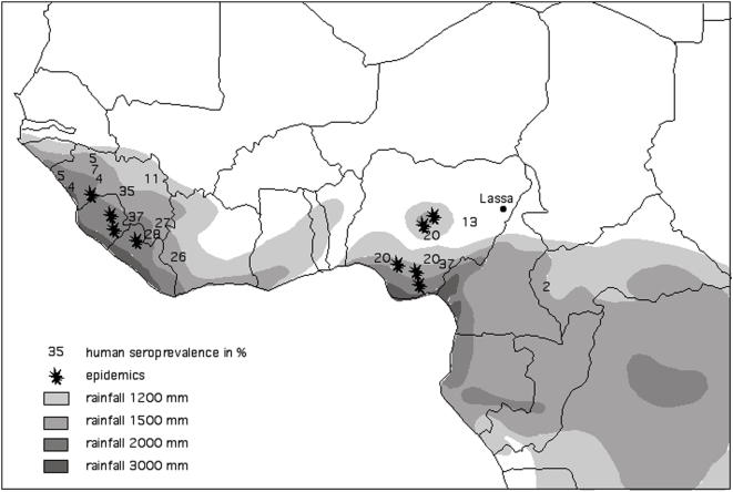
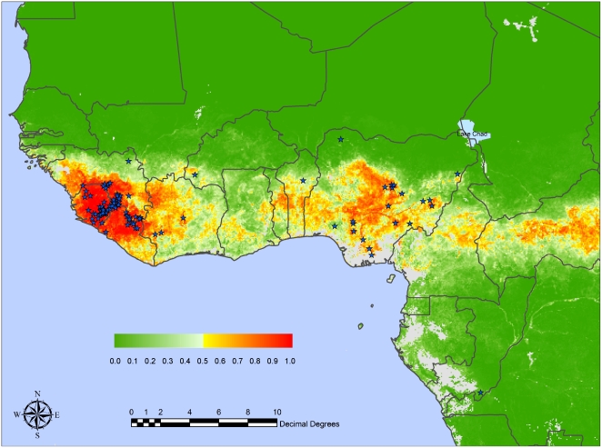
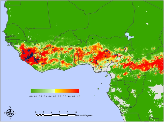
Methodology/principal findings: Three different analyses (models) are presented, one superimposing Lassa fever outbreaks on the mean rainfall surface (Model 1) and the other two using non-linear discriminant analytical techniques. Model 2 selected variables in a step-wise inclusive fashion, and Model 3 used an information-theoretic approach in which many different random combinations of 10 variables were fitted to the Lassa fever data. Three combinations of absenceratiopresence clusters were used in each of Models 2 and 3, the 2 absenceratio1 presence cluster combination giving what appeared to be the best result. Model 1 showed that the recorded outbreaks of Lassa fever in human populations occurred in zones receiving between 1,500 and 3,000 mm rainfall annually. Rainfall, and to a much lesser extent temperature variables, were most strongly selected in both Models 2 and 3, and neither vegetation nor altitude seemed particularly important. Both Models 2 and 3 produced mean kappa values in excess of 0.91 (Model 2) or 0.86 (Model 3), making them 'Excellent'.
Conclusion/significance: The Lassa fever areas predicted by the models cover approximately 80% of each of Sierra Leone and Liberia, 50% of Guinea, 40% of Nigeria, 30% of each of Côte d'Ivoire, Togo and Benin, and 10% of Ghana.
Conflict of interest statement
The authors have declared that no competing interests exist.
Figures
References
-
- Frame JD, Baldwin JMJ, Gocke DJ, Troup JM. Lassa fever, a new virus disease of man from West Africa. Am J Trop Med Hyg. 1970;19:670–676. - PubMed
-
- McCormick JB. Lassa fever. In: Saluzzo JF, Dodet B, editors. Emergence and control of rodent-borne viral diseases. Elsevier; 1999. pp. 177–195.
-
- Carey DE, Kemp GE, White HA, Pinneo L, Addy RF, et al. Lassa fever epidemiological aspects of the 1970 epidemic, Jos, Nigeria. T Roy Soc Trop Med H. 1972;66:402–408. - PubMed
-
- Frame JD, Jahrling PB, Yalley-Ogunro JE, Monson MH. Endemic Lassa fever in Liberia. II. Serological and virological findings in hospital patients. T Roy Soc Trop Med H. 1984;78:656–60. - PubMed
Publication types
MeSH terms
LinkOut - more resources
Full Text Sources
Other Literature Sources
