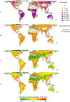
Global pyrogeography: the current and future distribution of wildfire
- PMID: 19352494
- PMCID: PMC2662419
- DOI: 10.1371/journal.pone.0005102
Global pyrogeography: the current and future distribution of wildfire
Abstract
Climate change is expected to alter the geographic distribution of wildfire, a complex abiotic process that responds to a variety of spatial and environmental gradients. How future climate change may alter global wildfire activity, however, is still largely unknown. As a first step to quantifying potential change in global wildfire, we present a multivariate quantification of environmental drivers for the observed, current distribution of vegetation fires using statistical models of the relationship between fire activity and resources to burn, climate conditions, human influence, and lightning flash rates at a coarse spatiotemporal resolution (100 km, over one decade). We then demonstrate how these statistical models can be used to project future changes in global fire patterns, highlighting regional hotspots of change in fire probabilities under future climate conditions as simulated by a global climate model. Based on current conditions, our results illustrate how the availability of resources to burn and climate conditions conducive to combustion jointly determine why some parts of the world are fire-prone and others are fire-free. In contrast to any expectation that global warming should necessarily result in more fire, we find that regional increases in fire probabilities may be counter-balanced by decreases at other locations, due to the interplay of temperature and precipitation variables. Despite this net balance, our models predict substantial invasion and retreat of fire across large portions of the globe. These changes could have important effects on terrestrial ecosystems since alteration in fire activity may occur quite rapidly, generating ever more complex environmental challenges for species dispersing and adjusting to new climate conditions. Our findings highlight the potential for widespread impacts of climate change on wildfire, suggesting severely altered fire regimes and the need for more explicit inclusion of fire in research on global vegetation-climate change dynamics and conservation planning.
Conflict of interest statement
Figures


References
-
- Lavorel S, Flannigan MD, Lambin EF, Scholes MC. Vulnerability of land systems to fire: Interactions among humans, climate, the atmosphere, and ecosystems. Mitigation Strategies for Global Change. 2006 DOI 10.1007/s11027-006-9046-5.
-
- Chuvieco E, Giglio L, Justice C. Global characterization of fire activity: toward defining fire regimes from Earth observation data. Global Change Biology. 2008;14:1–15.
-
- Calef MP, McGuire AD, Chapin FS. Human influences on wildfire in Alaska from 1988 through 2005: An analysis of the spatial patterns of human impacts. Earth Interactions. 2008;12
-
- Malilay J. A review of factors affecting the human health impacts of air pollutants from forest fires; Lima, Peru, 1988. World Health Organization; 1999.
-
- van der Werf GR, Randerson JT, Giglio L, Collatz GJ, Kasibhatla PS, et al. Interannual variability in global biomass burning emissions from 1997 to 2004. Atmospheric Chemistry and Physics. 2006;6:3423–3441.
Publication types
MeSH terms
LinkOut - more resources
Full Text Sources
Other Literature Sources
Research Materials

