

Political complexity predicts the spread of ethnolinguistic groups
- PMID: 19380740
- PMCID: PMC2670878
- DOI: 10.1073/pnas.0804698106
Political complexity predicts the spread of ethnolinguistic groups
Abstract
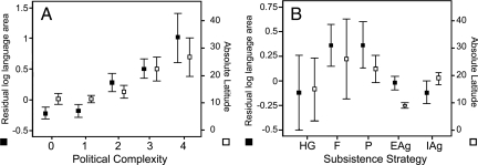
Human languages show a remarkable degree of variation in the area they cover. However, the factors governing the distribution of human cultural groups such as languages are not well understood. While previous studies have examined the role of a number of environmental variables the importance of cultural factors has not been systematically addressed. Here we use a geographical information system (GIS) to integrate information about languages with environmental, ecological, and ethnographic data to test a number of hypotheses that have been proposed to explain the global distribution of languages. We show that the degree of political complexity and type of subsistence strategy exhibited by societies are important predictors of the area covered by a language. Political complexity is also strongly associated with the latitudinal gradient in language area, whereas subsistence strategy is not. We argue that a process of cultural group selection favoring more complex societies may have been important in shaping the present-day global distribution of language diversity.
Conflict of interest statement
The authors declare no conflict of interest.
Figures

References
-
- Gordon RG., Jr . Ethnologue: Languages of the World. Dallas, Texas: SIL International; 2005.
-
- Pagel M, Mace R. The cultural wealth of nations. Nature. 2004;428:275–278. - PubMed
-
- Stevens GC. The latitudinal gradient in geographical range: How so many species coexist in the tropics. Am Nat. 1989;133:240–256.
-
- Willig MR, et al. Latitudinal gradients of biodiversity: Pattern, process, scale, and synthesis. Ann Rev Ecol Evol Sys. 2003;34:273–309.
-
- Mace R, Pagel M. A latitudinal gradient in the density of human languages in North America. Proc R Soc London Ser B. 1995;261:117–121.
Publication types
MeSH terms
LinkOut - more resources
Full Text Sources
