Navigational challenges in the oceanic migrations of leatherback sea turtles
- PMID: 19625321
- PMCID: PMC2817277
- DOI: 10.1098/rspb.2009.0965
Navigational challenges in the oceanic migrations of leatherback sea turtles
Abstract
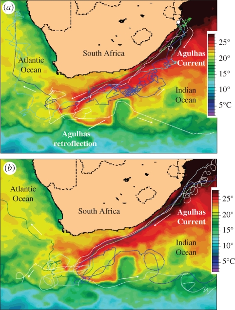
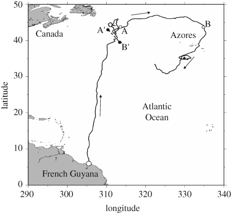
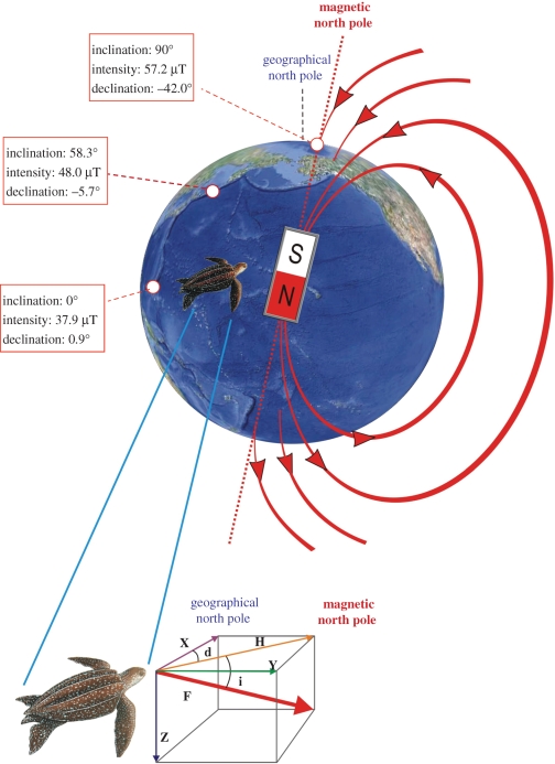
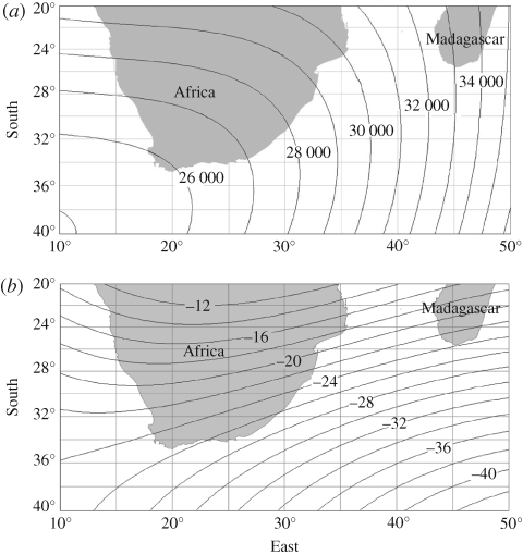
The open-sea movements of marine animals are affected by the drifting action of currents that, if not compensated for, can produce non-negligible deviations from the correct route towards a given target. Marine turtles are paradigmatic skilful oceanic navigators that are able to reach remote goals at the end of long-distance migrations, apparently overcoming current drift effects. Particularly relevant is the case of leatherback turtles (Dermochelys coriacea), which spend entire years in the ocean, wandering in search of planktonic prey. Recent analyses have revealed how the movements of satellite-tracked leatherbacks in the Indian, Atlantic and Pacific Oceans are strongly dependent on the oceanic currents, up to the point that turtles are often passively transported over long distances. However, leatherbacks are known to return to specific areas to breed every 2-3 years, thus finding their way back home after long periods in the oceanic environment. Here we examine the navigational consequences of the leatherbacks' close association with currents and discuss how the combined reliance on mechanisms of map-based navigation and local orientation cues close to the target may allow leatherbacks to accomplish the difficult task of returning to specific sites after years spent wandering in a moving medium.
Figures
Similar articles
-
Current transport of leatherback sea turtles (Dermochelys coriacea) in the ocean.Proc Biol Sci. 2003 Nov 7;270 Suppl 2(Suppl 2):S129-32. doi: 10.1098/rsbl.2003.0036. Proc Biol Sci. 2003. PMID: 14667360 Free PMC article.
-
A model for simulating the active dispersal of juvenile sea turtles with a case study on western Pacific leatherback turtles.PLoS One. 2017 Jul 26;12(7):e0181595. doi: 10.1371/journal.pone.0181595. eCollection 2017. PLoS One. 2017. PMID: 28746389 Free PMC article.
-
Persistent leatherback turtle migrations present opportunities for conservation.PLoS Biol. 2008 Jul 15;6(7):e171. doi: 10.1371/journal.pbio.0060171. PLoS Biol. 2008. PMID: 18630987 Free PMC article.
-
The sensory ecology of ocean navigation.J Exp Biol. 2008 Jun;211(Pt 11):1719-28. doi: 10.1242/jeb.015792. J Exp Biol. 2008. PMID: 18490387 Review.
-
The magnetic map of hatchling loggerhead sea turtles.Curr Opin Neurobiol. 2012 Apr;22(2):336-42. doi: 10.1016/j.conb.2011.11.005. Epub 2011 Nov 30. Curr Opin Neurobiol. 2012. PMID: 22137566 Review.
Cited by
-
Orientation behaviour of leatherback sea turtles within the North Atlantic subtropical gyre.Proc Biol Sci. 2015 Apr 7;282(1804):20143129. doi: 10.1098/rspb.2014.3129. Proc Biol Sci. 2015. PMID: 25761714 Free PMC article.
-
Bio-inspired machine-learning aided geo-magnetic field based AUV navigation system.Sci Rep. 2024 Aug 2;14(1):17912. doi: 10.1038/s41598-024-68950-2. Sci Rep. 2024. PMID: 39095609 Free PMC article.
-
Stochastic atmospheric assistance and the use of emergency staging sites by migrants.Proc Biol Sci. 2010 May 22;277(1687):1505-11. doi: 10.1098/rspb.2009.2112. Epub 2010 Jan 13. Proc Biol Sci. 2010. PMID: 20071381 Free PMC article.
-
Lost at sea: genetic, oceanographic and meteorological evidence for storm-forced dispersal.J R Soc Interface. 2012 Aug 7;9(73):1725-32. doi: 10.1098/rsif.2011.0788. Epub 2012 Feb 8. J R Soc Interface. 2012. PMID: 22319111 Free PMC article.
References
-
- Able K. P.2001The concepts and terminology of bird navigation. J. Avian Biol. 32, 174–183 (doi:10.1034/j.1600-048X.2001.320211.x) - DOI
-
- Åkesson S., Hedenström A.2007How migrants get there: migratory performance and orientation. BioScience 57, 123–133 (doi:10.1641/B570207) - DOI
-
- Alerstam T.2006Conflicting evidence about long-distance animal navigation. Science 313, 791–794 (doi:10.1126/science.1129048) - DOI - PubMed
-
- Alerstam T., Petterson S. G.1976Do birds use waves for orientation when migrating across the sea? Nature 259, 205–207 (doi:10.1038/259205a0) - DOI
-
- Avens L., Lohmann K. J.2003Use of multiple orientation cues by juvenile loggerhead sea turtles Caretta caretta. J. Exp. Biol. 206, 4317–4325 (doi:10.1242/jeb.00657) - DOI - PubMed
Publication types
MeSH terms
LinkOut - more resources
Full Text Sources