. 2009 Dec 1;106(48):20348-53.
doi: 10.1073/pnas.0903029106. Epub 2009 Nov 16.

Recent unprecedented tree-ring growth in bristlecone pine at the highest elevations and possible causes

Affiliations

Recent unprecedented tree-ring growth in bristlecone pine at the highest elevations and possible causes

Matthew W Salzer et al. Proc Natl Acad Sci U S A. .

Abstract

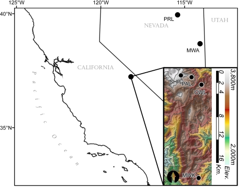
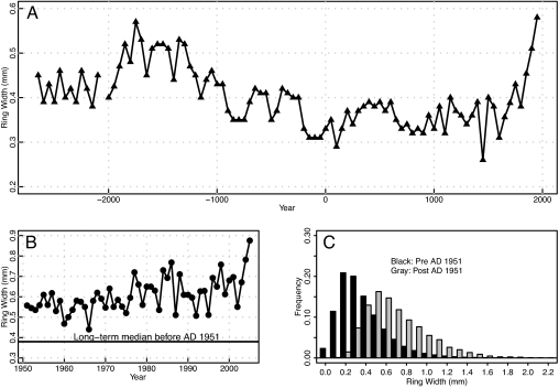
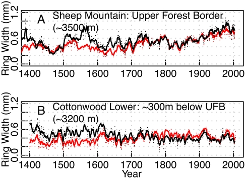
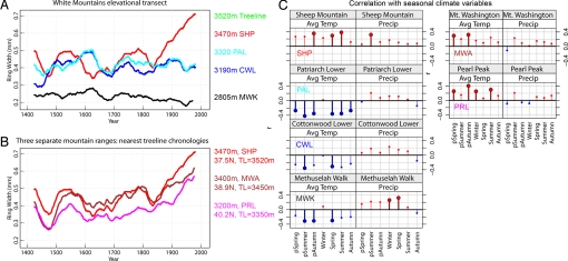
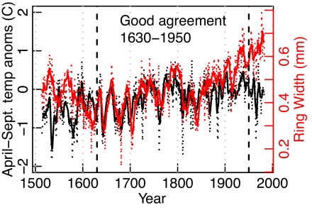
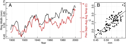
Great Basin bristlecone pine (Pinus longaeva) at 3 sites in western North America near the upper elevation limit of tree growth showed ring growth in the second half of the 20th century that was greater than during any other 50-year period in the last 3,700 years. The accelerated growth is suggestive of an environmental change unprecedented in millennia. The high growth is not overestimated because of standardization techniques, and it is unlikely that it is a result of a change in tree growth form or that it is predominantly caused by CO(2) fertilization. The growth surge has occurred only in a limited elevational band within approximately 150 m of upper treeline, regardless of treeline elevation. Both an independent proxy record of temperature and high-elevation meteorological temperature data are positively and significantly correlated with upper-treeline ring width both before and during the high-growth interval. Increasing temperature at high elevations is likely a prominent factor in the modern unprecedented level of growth for Pinus longaeva at these sites.


Conflict of interest statement

The authors declare no conflict of interest.

Figures

Fig. 1.
Fig. 1.
Map of the study area shows locations of 3 upper forest border sites: Sheep Mountain, CA (SHP); Mt. Washington, NV (MWA); and Pearl Peak, NV (PRL). The inset includes the other sites used in the White Mountains, CA elevational transect: Patriarch Lower (PAL), Cottonwood Lower (CWL), and Methuselah Walk (MWK) (contour intervals = 200 m).
Fig. 2.
Fig. 2.
Ring-width analysis of upper forest border Pinus longaeva from 3 sites (SHP, MWA, PRL) in western North America. (A) Ring-width medians for non-overlapping 50-year intervals plotted on first year of interval. (B) Annual ring-width medians for the period AD 1951–2005. The long-term median line is calculated for ring width before AD 1951. For comparison with Fig. 2A, the ring-width values for AD 2001–2005 have a median value of 0.67 mm (off the scale). The data for 2003–2005 are from SHP only. (C) Observed ring-width frequency distributions (SHP, MWA, PRL; n = 310,922 early, 9,316 late). Sites are separated into pre-AD 1951 (black) and post-AD 1950 (gray) sets.
Fig. 3.
Fig. 3.
Strip-bark and whole-bark ring-width chronologies from the White Mountains of California. Black chronologies are from whole-bark trees only; red chronologies are from strip-bark trees only. Note the similarity of whole-bark vs. strip-bark and the dissimilarity of the upper treeline (SHP) vs. the non-upper treeline (CWL). Smoothing was done with a 5-year moving average. (A) SHP (upper-treeline) ring-width chronologies. (B) CWL (non-upper-treeline) ring-width chronologies. SHP and CWL sites are separated by ≈3 km.
Fig. 4.
Fig. 4.
Pinus longaeva mean ring-width chronologies smoothed with a 50-year moving average and correlations between the White Mountain chronologies (unsmoothed) and climate data. (A) Chronologies across an elevational gradient in the White Mountains, CA. Note the difference between the highest site (SHP, upper treeline) and the other 3 sites (PAL, CWL, MWK) and the similarity of the lowest 3 sites to each other. (B) Upper-treeline chronologies from SHP in the White Mountains, CA, MWA in the Snake Range, NV, and PRL in the Ruby Range, NV. Note the similarity between these chronologies despite the distances between sites (≈200–500 km). (C) Correlation of chronologies with PRISM (21) temperature data (SHP 1896–2005, PAL and CWL 1896–2006, MWK 1896–1996, MWA and PRL 1896–2002). Bolded symbols are significant at P < 0.01. Note the similar pattern in the response to temperature between SHP and the other upper-treeline sites (MWA, PRL) and the switch in pattern in the response to temperature between SHP (upper treeline) and the 3 non-treeline sites. Winter = December, January, February; spring = March, April, May; summer = June, July, August; autumn = September, October, November.
Fig. 5.
Fig. 5.
Upper forest border regional ring width (red) compared with April-September temperature reconstructed from maximum latewood density (black) (22). The density series is an average of 2 grid points (37.5°N, 117.5°W; 37.5°N, 107.5°W) and was fitted with a 2-year moving average (t−1 and t) before plotting. Bold solid lines are center-plotted 5-year moving averages. The 2 series are completely independent.
Fig. 6.
Fig. 6.
Upper forest border regional ring width compared with regional high-elevation PRISM3 (21) temperature data. (A) Time-series plot of smoothed ring width (red) and temperature (black). Series were smoothed with a center-plotted 5-year moving average. Ring-width series is GBR3. Temperature series is PRISM3, previous September-August mean of 3 pixels closest to SHP, MWA, PRL sites. (B) Scatterplot of the same 2 variables. The 3 points in the upper-right corner are the 3 most recent 5-year periods.

References

    1. Hughes MK, Graumlich LJ. Multimillennial dendroclimatic records from western North America. In: Jones PD, Bradley RS, Jouzel J, editors. Climatic Variations and Forcing Mechanisms of the Last 2000 Years. Vol 41. New York: Springer-Verlag; 1996. pp. 109–124. NATO Advanced Science Institutes Series I.
    1. LaMarche VC., Jr. Frequency-dependent relationships between tree-ring series along an ecological gradient and some dendrochronological implications. Tree-Ring Bulletin. 1974;34:1–20.
    1. Graumlich LJ. A 1000-year record of temperature and precipitation in the Sierra Nevada. Quaternary Research. 1993;39:249–255.
    1. Graybill DA, Funkhouser GS. Dendroclimatic reconstructions during the past millennium in the southern Sierra Nevada and Owens Valley, California. In: Rose MR, Wigand PE, editors. Proceedings of the Southern California Climate Symposium: Trends and Extremes of the Past 2000 Years. Natural History; Los Angeles: Museum of Los Angeles County; 1999. pp. 239–269.
    1. Hughes MK, Funkhouser GS. Frequency-dependent climate signal in upper and lower forest border tree rings in the mountains of the Great Basin. Climatic Change. 2003;59:233–244.

Publication types