

Using high spatial resolution remote sensing for risk mapping of malaria occurrence in the Nouna district, Burkina Faso
- PMID: 20052428
- PMCID: PMC2799258
- DOI: 10.3402/gha.v2i0.2094
Using high spatial resolution remote sensing for risk mapping of malaria occurrence in the Nouna district, Burkina Faso
Abstract
Introduction: Malaria control measures such as early diagnosis and treatment, intermittent treatment of pregnant women, impregnated bed nets, indoor spraying and larval control measures are difficult to target specifically because of imprecise estimates of risk at a small-scale level. Ways of estimating local risks for malaria are therefore important.
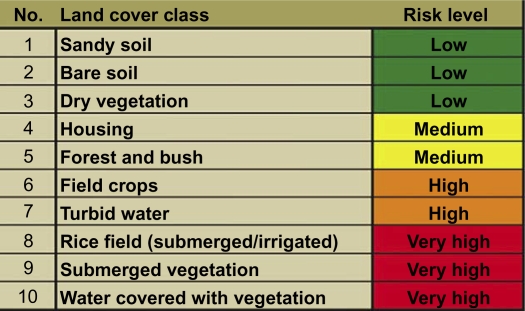
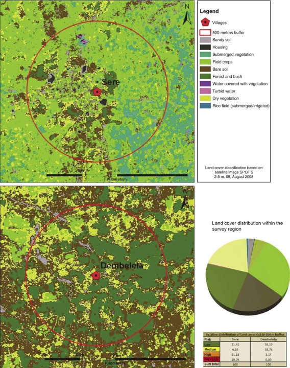
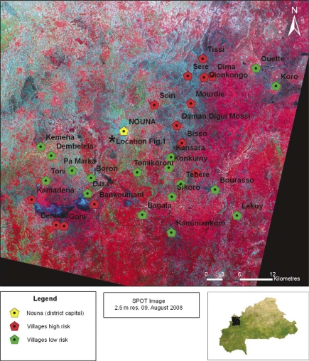
Methods: A high-resolution satellite view from the SPOT 5 satellite during 2008 was used to generate a land cover classification in the malaria endemic lowland of North-Western Burkina Faso. For the area of a complete satellite view of 60 x 60 km, a supervised land cover classification was carried out. Ten classes were built and correlated to land cover types known for acting as Anopheles mosquito breeding sites.
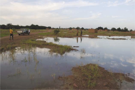
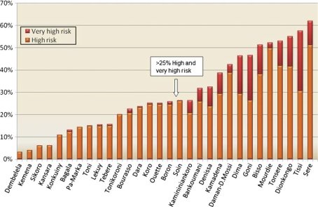
Results: According to known correlations of Anopheles larvae presence and surface water-related land cover, cultivated areas in the riverine vicinity of Kossi River were shown to be one of the most favourable sites for Anopheles production. Similar conditions prevail in the South of the study region, where clayey soils and higher precipitations benefit the occurrence of surface water. Besides pools, which are often directly detectable, rice fields and occasionally flooded crops represent most appropriate habitats. On the other hand, forests, elevated regions on porous soils, grasslands and the dryer, sandy soils in the north-western part turned out to deliver fewer mosquito breeding opportunities.
Conclusions: Potential high and low risks for malaria at the village level can be differentiated from satellite data. While much remains to be done in terms of establishing correlations between remotely sensed risks and malaria disease patterns, this is a potentially useful approach which could lead to more focused disease control programmes.
Keywords: Anopheles; Burkina Faso; SPOT 5 satellite; West Africa; high spatial resolution; malaria; remote sensing; risk mapping.
Figures
Similar articles
-
Utilization of combined remote sensing techniques to detect environmental variables influencing malaria vector densities in rural West Africa.Int J Health Geogr. 2012 Mar 23;11:8. doi: 10.1186/1476-072X-11-8. Int J Health Geogr. 2012. PMID: 22443452 Free PMC article.
-
Identification and characterization of larval and adult anopheline mosquito habitats in the Republic of Korea: potential use of remotely sensed data to estimate mosquito distributions.Int J Health Geogr. 2005 Jul 13;4:17. doi: 10.1186/1476-072X-4-17. Int J Health Geogr. 2005. PMID: 16011809 Free PMC article.
-
Routine implementation costs of larviciding with Bacillus thuringiensis israelensis against malaria vectors in a district in rural Burkina Faso.Malar J. 2016 Jul 22;15(1):380. doi: 10.1186/s12936-016-1438-8. Malar J. 2016. PMID: 27449023 Free PMC article.
-
[Current malaria situation in the Republic of Kazakhstan].Med Parazitol (Mosk). 2001 Jan-Mar;(1):24-33. Med Parazitol (Mosk). 2001. PMID: 11548308 Russian.
-
Satellite Observations and Malaria: New Opportunities for Research and Applications.Trends Parasitol. 2021 Jun;37(6):525-537. doi: 10.1016/j.pt.2021.03.003. Epub 2021 Mar 25. Trends Parasitol. 2021. PMID: 33775559 Free PMC article. Review.
Cited by
-
Applications of Space Technologies to Global Health: Scoping Review.J Med Internet Res. 2018 Jun 27;20(6):e230. doi: 10.2196/jmir.9458. J Med Internet Res. 2018. PMID: 29950289 Free PMC article.
-
A cloud-based toolbox for the versatile environmental annotation of biodiversity data.PLoS Biol. 2021 Nov 15;19(11):e3001460. doi: 10.1371/journal.pbio.3001460. eCollection 2021 Nov. PLoS Biol. 2021. PMID: 34780461 Free PMC article.
-
The Health and Demographic Surveillance System (HDSS) in Nouna, Burkina Faso, 1993-2007.Glob Health Action. 2010 Sep 14;3. doi: 10.3402/gha.v3i0.5284. Glob Health Action. 2010. PMID: 20847837 Free PMC article.
-
IgG responses to the gSG6-P1 salivary peptide for evaluating human exposure to Anopheles bites in urban areas of Dakar region, Sénégal.Malar J. 2012 Mar 16;11:72. doi: 10.1186/1475-2875-11-72. Malar J. 2012. PMID: 22424570 Free PMC article.
-
Longitudinal study on the temporal and micro-spatial distribution of Galba truncatula in four farms in Belgium as a base for small-scale risk mapping of Fasciola hepatica.Parasit Vectors. 2014 Nov 26;7:528. doi: 10.1186/s13071-014-0528-0. Parasit Vectors. 2014. PMID: 25425397 Free PMC article.
References
-
- Krause G, Sauerborn R. Comprehensive community effectiveness of health care. A study of malaria treatment in children and adults in rural Burkina Faso. Ann Trop Paediatr. 2000;20:273–82. - PubMed
-
- Pfeiffer K, Somé F, Müller O, Sie A, Kouyate B, Haefeli WE, et al. Clinical diagnosis of malaria and the risk of chloroquine self-medication in rural health centres in Burkina Faso. Trop Med Int Health. 2008;13:418–26. - PubMed
-
- WHO. World malaria report. Geneva, Switzerland: WHO; 2008.
-
- Briet OJT, Dossou-Yovo J, Akodo E, van de Giesen N, Teuscher TM. The relationship between Anopheles gambiae density and rice cultivation in the savannah zone and forest zone of Cote d'Ivoire. Trop Med Int Health. 2003;8:439–48. - PubMed
LinkOut - more resources
Full Text Sources