

Enhancing spatial detection accuracy for syndromic surveillance with street level incidence data
- PMID: 20082711
- PMCID: PMC2819064
- DOI: 10.1186/1476-072X-9-1
Enhancing spatial detection accuracy for syndromic surveillance with street level incidence data
Abstract
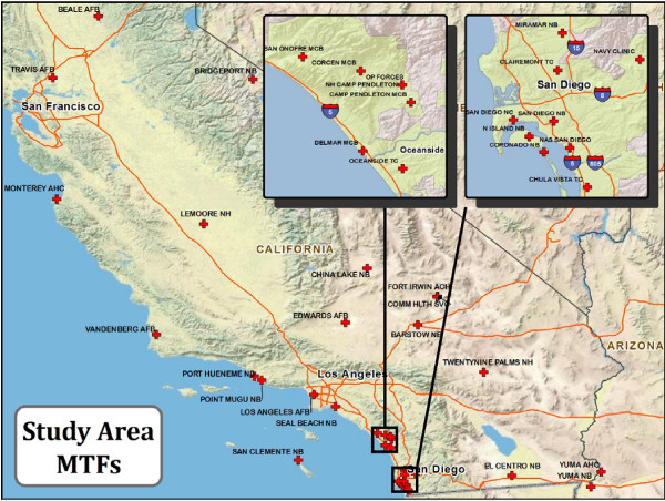
Background: The Department of Defense Military Health System operates a syndromic surveillance system that monitors medical records at more than 450 non-combat Military Treatment Facilities (MTF) worldwide. The Electronic Surveillance System for Early Notification of Community-based Epidemics (ESSENCE) uses both temporal and spatial algorithms to detect disease outbreaks. This study focuses on spatial detection and attempts to improve the effectiveness of the ESSENCE implementation of the spatial scan statistic by increasing the spatial resolution of incidence data from zip codes to street address level.
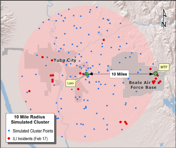
Methods: Influenza-Like Illness (ILI) was used as a test syndrome to develop methods to improve the spatial accuracy of detected alerts. Simulated incident clusters of various sizes were superimposed on real ILI incidents from the 2008/2009 influenza season. Clusters were detected using the spatial scan statistic and their displacement from simulated loci was measured. Detected cluster size distributions were also evaluated for compliance with simulated cluster sizes.
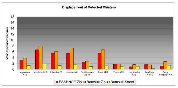
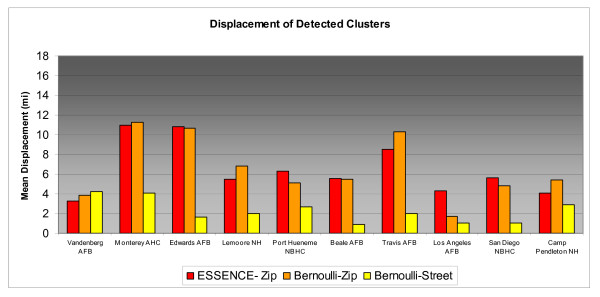
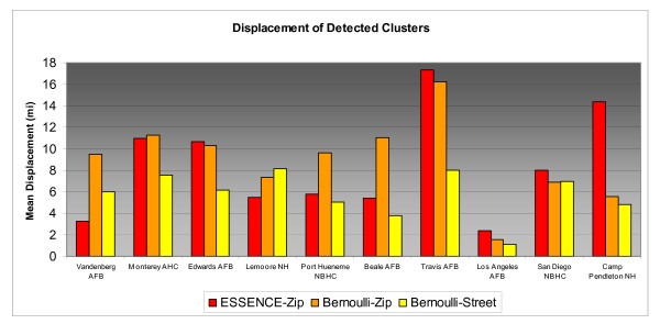
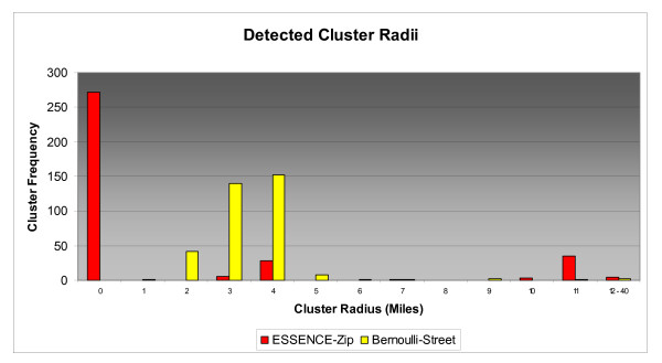
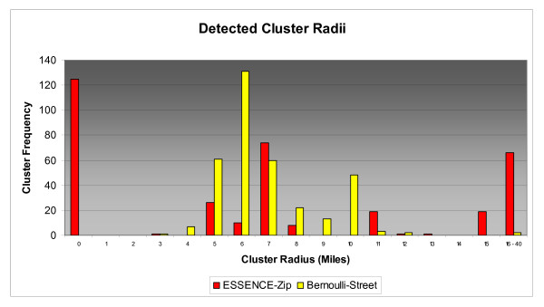
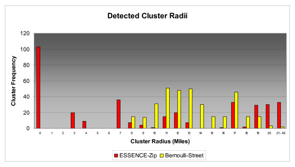
Results: Relative to the ESSENCE zip code based method, clusters detected using street level incidents were displaced on average 65% less for 2 and 5 mile radius clusters and 31% less for 10 mile radius clusters. Detected cluster size distributions for the street address method were quasi normal and sizes tended to slightly exceed simulated radii. ESSENCE methods yielded fragmented distributions and had high rates of zero radius and oversized clusters.
Conclusions: Spatial detection accuracy improved notably with regard to both location and size when incidents were geocoded to street addresses rather than zip code centroids. Since street address geocoding success rates were only 73.5%, zip codes were still used for more than one quarter of ILI cases. Thus, further advances in spatial detection accuracy are dependant on systematic improvements in the collection of individual address information.
Figures
Similar articles
-
Evaluating real-time syndromic surveillance signals from ambulatory care data in four states.Public Health Rep. 2010 Jan-Feb;125(1):111-20. doi: 10.1177/003335491012500115. Public Health Rep. 2010. PMID: 20402203 Free PMC article.
-
Privacy protection versus cluster detection in spatial epidemiology.Am J Public Health. 2006 Nov;96(11):2002-8. doi: 10.2105/AJPH.2005.069526. Epub 2006 Oct 3. Am J Public Health. 2006. PMID: 17018828 Free PMC article.
-
The reliability of tweets as a supplementary method of seasonal influenza surveillance.J Med Internet Res. 2014 Nov 14;16(11):e250. doi: 10.2196/jmir.3532. J Med Internet Res. 2014. PMID: 25406040 Free PMC article.
-
A systems overview of the Electronic Surveillance System for the Early Notification of Community-Based Epidemics (ESSENCE II).J Urban Health. 2003 Jun;80(2 Suppl 1):i32-42. doi: 10.1007/pl00022313. J Urban Health. 2003. PMID: 12791777 Free PMC article. Review.
-
Cluster Detection Mechanisms for Syndromic Surveillance Systems: Systematic Review and Framework Development.JMIR Public Health Surveill. 2020 May 26;6(2):e11512. doi: 10.2196/11512. JMIR Public Health Surveill. 2020. PMID: 32357126 Free PMC article.
Cited by
-
An integrative review of information systems and terminologies used in local health departments.J Am Med Inform Assoc. 2014 Feb;21(e1):e20-7. doi: 10.1136/amiajnl-2013-001714. Epub 2013 Sep 13. J Am Med Inform Assoc. 2014. PMID: 24036156 Free PMC article. Review.
-
Automated surveillance of 911 call data for detection of possible water contamination incidents.Int J Health Geogr. 2011 Mar 30;10:22. doi: 10.1186/1476-072X-10-22. Int J Health Geogr. 2011. PMID: 21450105 Free PMC article.
-
Utility of Spatial Point-Pattern Analysis Using Residential and Workplace Geospatial Information to Localize Potential Outbreak Sources.Am J Epidemiol. 2019 May 1;188(5):940-949. doi: 10.1093/aje/kwy290. Am J Epidemiol. 2019. PMID: 30877759 Free PMC article.
-
Spatial accessibility modeling to healthcare facilities in the case of health shocks of Midnapore municipality, India.GeoJournal. 2023 Feb 11:1-24. doi: 10.1007/s10708-023-10838-1. Online ahead of print. GeoJournal. 2023. PMID: 38625266 Free PMC article.
-
Integrating novel data streams to support biosurveillance in commercial livestock production systems in developed countries: challenges and opportunities.Front Public Health. 2015 Apr 28;3:74. doi: 10.3389/fpubh.2015.00074. eCollection 2015. Front Public Health. 2015. PMID: 25973416 Free PMC article. Review.
References
-
- Kulldorff M, Information Management Services, Inc. SaTScan™ V7.0: Software for the spatial and space-time scan statistics. 2006. http://www.satscan.org
-
- Kulldorff M. A spatial scan statistic. Commun Stat Theory Methods. 1997;26:1481–1496. doi: 10.1080/03610929708831995. - DOI
MeSH terms
Grants and funding
LinkOut - more resources
Full Text Sources
Medical
Miscellaneous
