. 2010 Apr 13;107(15):6748-52.
doi: 10.1073/pnas.0910827107. Epub 2010 Mar 29.

Climate as a contributing factor in the demise of Angkor, Cambodia

Affiliations

Climate as a contributing factor in the demise of Angkor, Cambodia

Brendan M Buckley et al. Proc Natl Acad Sci U S A. .

Abstract

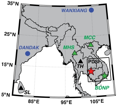
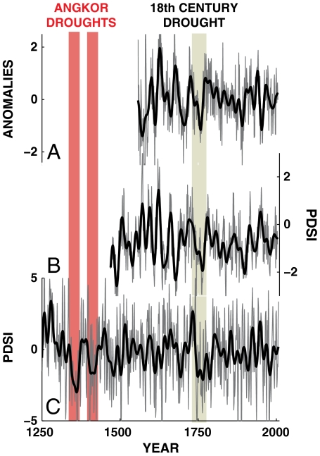
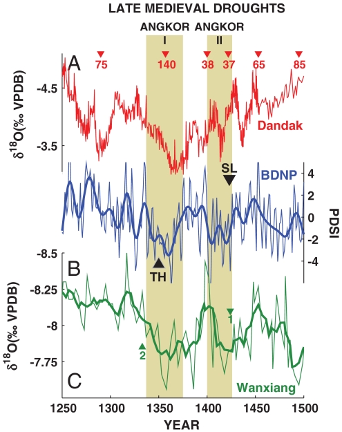
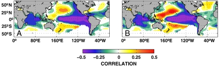
The "hydraulic city" of Angkor, the capitol of the Khmer Empire in Cambodia, experienced decades-long drought interspersed with intense monsoons in the fourteenth and fifteenth centuries that, in combination with other factors, contributed to its eventual demise. The climatic evidence comes from a seven-and-a-half century robust hydroclimate reconstruction from tropical southern Vietnamese tree rings. The Angkor droughts were of a duration and severity that would have impacted the sprawling city's water supply and agricultural productivity, while high-magnitude monsoon years damaged its water control infrastructure. Hydroclimate variability for this region is strongly and inversely correlated with tropical Pacific sea surface temperature, indicating that a warm Pacific and El Niño events induce drought at interannual and interdecadal time scales, and that low-frequency variations of tropical Pacific climate can exert significant influence over Southeast Asian climate and society.


Conflict of interest statement

The authors declare no conflict of interest.

Figures

Fig. 1.
Fig. 1.
Geographic context for the present study. The location of Angkor is marked by the red star in Cambodia. The map indicates the locations of the three tree-ring climate reconstructions discussed in the text with green symbols: MHS (10), MCC (11), and the BDNP Fokienia hodginsii site (this study, the green star in southern Vietnam) presented in this paper. Speleothem proxy records covering the fourteenth and fifteenth centuries are found at Dandak Cave in India (17) and Wanxiang Cave in China (18) as indicated by blue circles. Additional historical, documentary records of the fourteenth and fifteenth century droughts come from Phitsanulok in modern Thailand (TH) and Sri Lanka (SL) (14, 16), and whose locations are indicated by black triangles. The nine PDSI grid boxes that were used for paleoclimate reconstruction are shown by the box (15).
Fig. 2.
Fig. 2.
Tree-ring reconstructed drought from Southeast Asia. (A) MHS-inferred PDSI normalized anomalies (10) from teak, (B) MCC reconstructed PDSI (11) from Po Mu (Fokienia hodginsii), and (C) the new BDNP reconstructed PDSI from Po Mu (F. hodginsii). The two Angkor Droughts in the late fourteenth and early fifteenth centuries are indicated by red vertical bars. A more recent drought in the middle of the eighteenth century is indicated in each reconstruction by the brown bar.
Fig. 3.
Fig. 3.
Regional paleoclimate records of Medieval Drought in Southeast Asia. Dandak Cave δ18O record (A) from the core monsoon region of India (17, 52), our Bidoup Nui Ba National Park (BDNP) PDSI reconstruction (B, with heavy line 15-year Butterworth filter from southern Vietnam), and the speleothem δ18O record from Wanxiang Cave (C, heavy line, five-point boxcar filter) in China (18). Note that axes for both speleothem records are inverted such that drier conditions are down. U/Th dates for speleothems are shown by filled triangles of the same color with analytical error estimates (± years) shown by the accompanying number. The fourteenth and early fifteenth century Angkor droughts are indicated by the brown shaded bars. Historical records of the fourteenth and fifteenth century droughts come from Phitsanulok in modern Thailand (TH) and Sri Lanka (SL) (14, 16) and are indicated by black triangles.
Fig. 4.
Fig. 4.
Correlation maps between drought (15) and sea surface temperatures (19). Significant (p < 0.001) correlations are identified between (A) the BDNP PDSI reconstruction and tropical Pacific and Indian Ocean SSTs (1856–2006), with positive anomalies in the extratropical Pacific. The same pattern is identified for (B) the instrumental PDSI record [1915–2005 (15)].

References

    1. Fletcher RJ, et al. Redefining Angkor: Structure and environment in the largest, low density urban complex of the pre-industrial world. UDAYA. 2003;4:107–121.
    1. Groslier B. La cité hydraulique angkorienne: Exploitation ou surexploitation du sol? Bulletin de l’Ecole française d’Extrême-Orient. 1979;66:161–202.
    1. deMenocal PB. Cultural responses to climate change during the late Holocene. Science. 2001;292:667–673. - PubMed
    1. Haug GH, et al. Climate and the collapse of Maya civilization. Science. 2003;299:1731–1735. - PubMed
    1. Peterson L, Haug G. Climate and the collapse of Maya civilization. Am Sci. 2005;93:322–29. - PubMed

Publication types

LinkOut - more resources