

HEALTH GeoJunction: place-time-concept browsing of health publications
- PMID: 20482806
- PMCID: PMC2889882
- DOI: 10.1186/1476-072X-9-23
HEALTH GeoJunction: place-time-concept browsing of health publications
Abstract
Background: The volume of health science publications is escalating rapidly. Thus, keeping up with developments is becoming harder as is the task of finding important cross-domain connections. When geographic location is a relevant component of research reported in publications, these tasks are more difficult because standard search and indexing facilities have limited or no ability to identify geographic foci in documents. This paper introduces HEALTH GeoJunction, a web application that supports researchers in the task of quickly finding scientific publications that are relevant geographically and temporally as well as thematically.
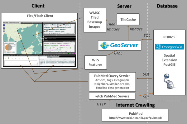
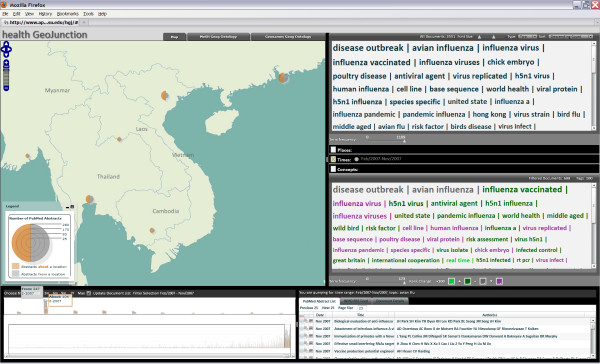
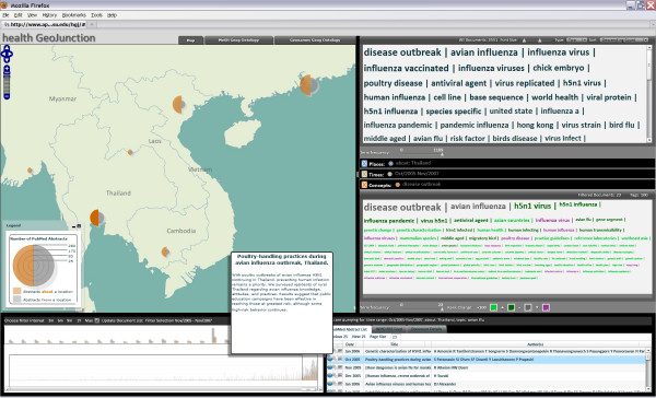
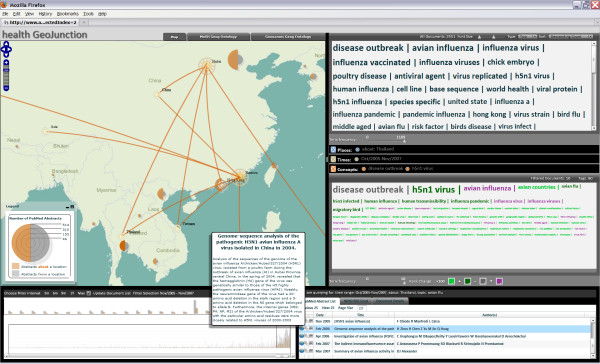
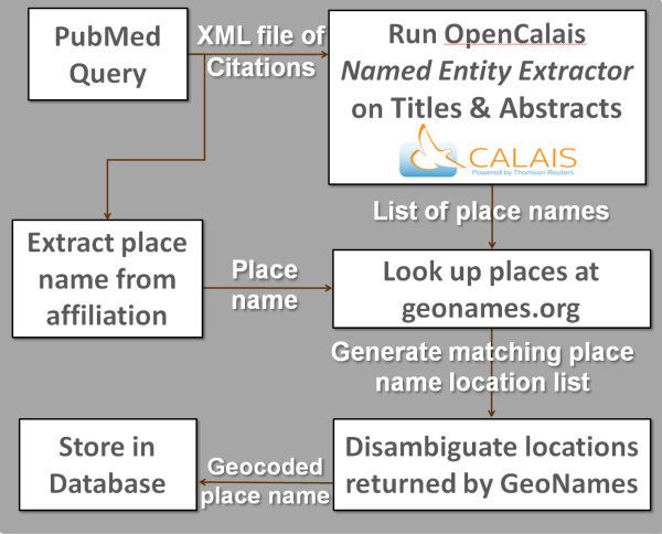
Results: HEALTH GeoJunction is a geovisual analytics-enabled web application providing: (a) web services using computational reasoning methods to extract place-time-concept information from bibliographic data for documents and (b) visually-enabled place-time-concept query, filtering, and contextualizing tools that apply to both the documents and their extracted content. This paper focuses specifically on strategies for visually-enabled, iterative, facet-like, place-time-concept filtering that allows analysts to quickly drill down to scientific findings of interest in PubMed abstracts and to explore relations among abstracts and extracted concepts in place and time. The approach enables analysts to: find publications without knowing all relevant query parameters, recognize unanticipated geographic relations within and among documents in multiple health domains, identify the thematic emphasis of research targeting particular places, notice changes in concepts over time, and notice changes in places where concepts are emphasized.
Conclusions: PubMed is a database of over 19 million biomedical abstracts and citations maintained by the National Center for Biotechnology Information; achieving quick filtering is an important contribution due to the database size. Including geography in filters is important due to rapidly escalating attention to geographic factors in public health. The implementation of mechanisms for iterative place-time-concept filtering makes it possible to narrow searches efficiently and quickly from thousands of documents to a small subset that meet place-time-concept constraints. Support for a more-like-this query creates the potential to identify unexpected connections across diverse areas of research. Multi-view visualization methods support understanding of the place, time, and concept components of document collections and enable comparison of filtered query results to the full set of publications.
Figures

Similar articles
-
The BioPrompt-box: an ontology-based clustering tool for searching in biological databases.BMC Bioinformatics. 2007 Mar 8;8 Suppl 1(Suppl 1):S8. doi: 10.1186/1471-2105-8-S1-S8. BMC Bioinformatics. 2007. PMID: 17430575 Free PMC article.
-
G-Bean: an ontology-graph based web tool for biomedical literature retrieval.BMC Bioinformatics. 2014;15 Suppl 12(Suppl 12):S1. doi: 10.1186/1471-2105-15-S12-S1. Epub 2014 Nov 6. BMC Bioinformatics. 2014. PMID: 25474588 Free PMC article.
-
Concept-based query expansion for retrieving gene related publications from MEDLINE.BMC Bioinformatics. 2010 Apr 28;11:212. doi: 10.1186/1471-2105-11-212. BMC Bioinformatics. 2010. PMID: 20426836 Free PMC article.
-
Interactive text mining with Pipeline Pilot: a bibliographic web-based tool for PubMed.Infect Disord Drug Targets. 2009 Jun;9(3):366-74. doi: 10.2174/1871526510909030366. Infect Disord Drug Targets. 2009. PMID: 19519489 Review.
-
Exploitation of ontological resources for scientific literature analysis: searching genes and related diseases.Annu Int Conf IEEE Eng Med Biol Soc. 2009;2009:7073-8. doi: 10.1109/IEMBS.2009.5333359. Annu Int Conf IEEE Eng Med Biol Soc. 2009. PMID: 19964204 Review.
Cited by
-
Drowning--a scientometric analysis and data acquisition of a constant global problem employing density equalizing mapping and scientometric benchmarking procedures.Int J Health Geogr. 2011 Oct 14;10:55. doi: 10.1186/1476-072X-10-55. Int J Health Geogr. 2011. PMID: 21999813 Free PMC article.
References
-
- Jones CB, Purves RS. Geographical information retrieval. International Journal of Geographical Information Science. 2008;22(3):219–228. doi: 10.1080/13658810701626343. - DOI
-
- Leidner JL. Toponym resolution in text: annotation, evaluation and applications of spatial grounding. SIGIR Forum. 2007;41(2):124–126. doi: 10.1145/1328964.1328989. - DOI
-
- Overell S, Rüger S. Using co-occurrence models for placename disambiguation. International Journal of Geographical Information Science. 2008;22(3):265–287. doi: 10.1080/13658810701626236. - DOI
-
- Goldberg DW, Wilson JP, Knoblock CA. From Text to Geographic Coordinates: The Current State of Geocoding. Journal of the Urban and Regional Information Systems Association. 2007;19(1):33–46.
-
- Hobona G, James P, Fairbairn D. Multidimensional visualisation of degrees of relevance of geographic data. International Journal of Geographical Information Science. 2006;20(5):469–490. doi: 10.1080/13658810600607634. - DOI
Publication types
MeSH terms
LinkOut - more resources
Full Text Sources
Other Literature Sources
