

The spatial-temporal clustering of Plasmodium falciparum infection over eleven years in Gezira State, The Sudan
- PMID: 20565854
- PMCID: PMC2903606
- DOI: 10.1186/1475-2875-9-172
The spatial-temporal clustering of Plasmodium falciparum infection over eleven years in Gezira State, The Sudan
Abstract
Background: Malaria infection and disease exhibit microgeographic heterogeneity which if predictable could have implications for designing small-area intervention. Here, the space-time clustering of Plasmodium falciparum infections using data from repeat cross-sectional surveys in Gezira State, a low transmission area in northern Sudan, is investigated.
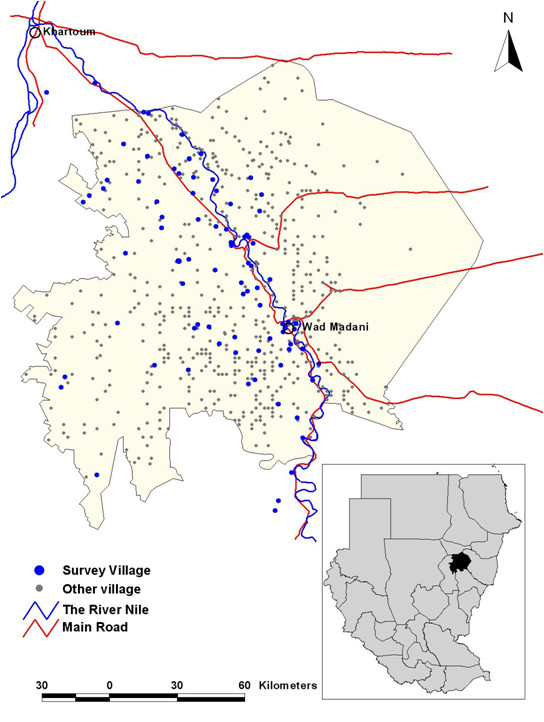
Methods: Data from cross-sectional surveys undertaken in January each year from 1999-2009 in 88 villages in the Gezira state were assembled. During each survey, about a 100 children between the ages two to ten years were sampled to examine the presence of P. falciparum parasites. In 2009, all the villages were mapped using global positioning systems. Cluster level data were analysed for spatial-only and space-time clustering using the Bernoulli model and the significance of clusters were tested using the Kulldorff scan statistic.
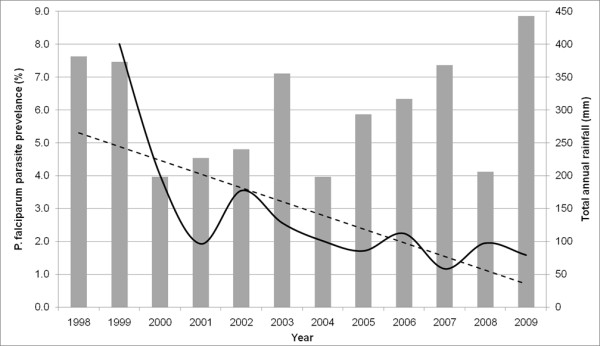
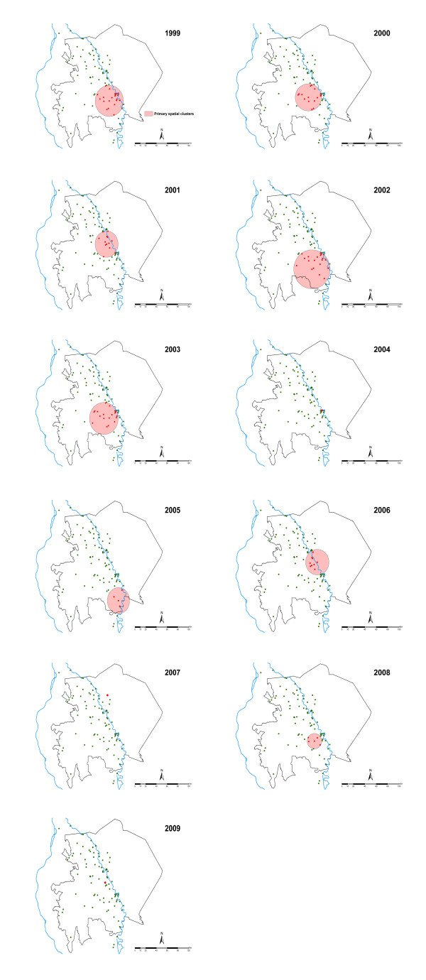
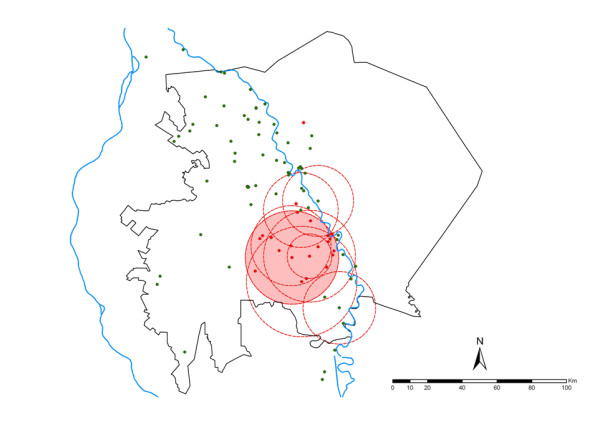
Results: Over the study period, 96,022 malaria slide examinations were undertaken and the P. falciparum prevalence was 8.6% in 1999 and by 2009 this had reduced to 1.6%. The cluster analysis showed the presence of one significant spatial-only cluster in each survey year and one significant space-time cluster over the whole study period. The primary spatial-only clusters in 10/11 years were either contained within or overlapped with the primary space-time cluster.
Conclusion: The results of the study confirm the generally low malaria transmission in the state of Gezira and the presence of spatial and space-time clusters concentrated around a specific area in the south of the state. Improved surveillance data that allows for the analysis of seasonality, age and other risk factors need to be collected to design effective small area interventions as Gezira state targets malaria elimination.
Figures
Similar articles
-
Malaria risk factors in north-east Tanzania.Malar J. 2011 Apr 20;10:98. doi: 10.1186/1475-2875-10-98. Malar J. 2011. PMID: 21507217 Free PMC article.
-
Identifying residual foci of Plasmodium falciparum infections for malaria elimination: the urban context of Khartoum, Sudan.PLoS One. 2011 Feb 23;6(2):e16948. doi: 10.1371/journal.pone.0016948. PLoS One. 2011. PMID: 21373202 Free PMC article.
-
Household level spatio-temporal analysis of Plasmodium falciparum and Plasmodium vivax malaria in Ethiopia.Parasit Vectors. 2017 Apr 20;10(1):196. doi: 10.1186/s13071-017-2124-6. Parasit Vectors. 2017. PMID: 28427451 Free PMC article.
-
The analysis of disease clusters, Part II: Introduction to techniques.Infect Control Hosp Epidemiol. 1996 Jun;17(6):385-97. doi: 10.1086/647325. Infect Control Hosp Epidemiol. 1996. PMID: 8805074 Review.
-
Disease cluster statistics for imprecise space-time locations.Stat Med. 1996 Apr 15-May 15;15(7-9):873-85. doi: 10.1002/(sici)1097-0258(19960415)15:7/9<873::aid-sim256>3.0.co;2-u. Stat Med. 1996. PMID: 8861156 Review.
Cited by
-
Effect of bednets and indoor residual spraying on spatio-temporal clustering of malaria in a village in south Ethiopia: a longitudinal study.PLoS One. 2012;7(10):e47354. doi: 10.1371/journal.pone.0047354. Epub 2012 Oct 12. PLoS One. 2012. PMID: 23077598 Free PMC article.
-
Spatial and spatio-temporal methods for mapping malaria risk: a systematic review.BMJ Glob Health. 2020 Oct;5(10):e002919. doi: 10.1136/bmjgh-2020-002919. BMJ Glob Health. 2020. PMID: 33023880 Free PMC article.
-
Estimating individual exposure to malaria using local prevalence of malaria infection in the field.PLoS One. 2012;7(3):e32929. doi: 10.1371/journal.pone.0032929. Epub 2012 Mar 29. PLoS One. 2012. PMID: 22479349 Free PMC article.
-
Cluster analysis of hemorrhagic disease in Missouri's white-tailed deer population: 1980-2013.BMC Ecol. 2018 Sep 14;18(1):35. doi: 10.1186/s12898-018-0188-6. BMC Ecol. 2018. PMID: 30217140 Free PMC article.
-
Malaria risk factors in north-east Tanzania.Malar J. 2011 Apr 20;10:98. doi: 10.1186/1475-2875-10-98. Malar J. 2011. PMID: 21507217 Free PMC article.
References
-
- Cattani JA, Tulloch JL, Vrbova H, Jolley D, Gibson FD, Moir JS, Heywood PF, Alpers MP, Stevenson A, Clancy R. The epidemiology of malaria in a population surrounding Madang, Papua New Guinea. Am J Trop Med Hyg. 1986;35:3–15. - PubMed
-
- Gamage-Mendis AC, Carter R, Mendis C, De Zoysa AP, Herath PR, Mendis KN. Clustering of malaria infections within an endemic population: risk of malaria associated with the type of housing construction. Am J Trop Med Hyg. 1991;45:77–85. - PubMed
Publication types
MeSH terms
Grants and funding
LinkOut - more resources
Full Text Sources
