. 2010 Jul 6;107(27):12222-7.
doi: 10.1073/pnas.1002971107. Epub 2010 Jun 21.

International population movements and regional Plasmodium falciparum malaria elimination strategies

Affiliations

International population movements and regional Plasmodium falciparum malaria elimination strategies

Andrew J Tatem et al. Proc Natl Acad Sci U S A. .

Abstract

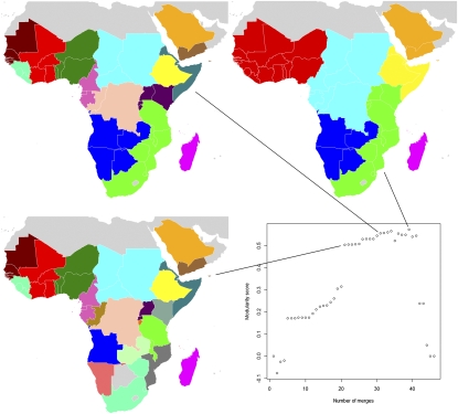
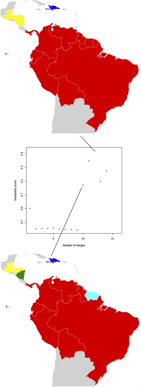
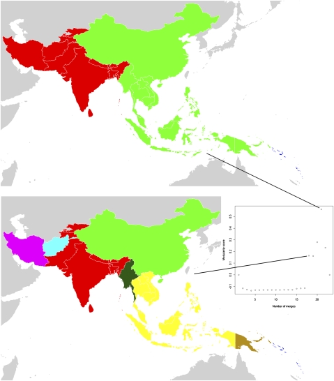
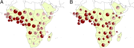
Calls for the eradication of malaria require the development of global and regional strategies based on a strong and consistent evidence base. Evidence from the previous global malaria eradication program and more recent transborder control campaigns have shown the importance of accounting for human movement in introducing infections to areas targeted for elimination. Here, census-based migration data were analyzed with network analysis tools, Plasmodium falciparum malaria transmission maps, and global population databases to map globally communities of countries linked by relatively high levels of infection movements. The likely principal sources and destinations of imported cases in each region were also mapped. Results indicate that certain groups of countries, such as those in West Africa and central Asia are much more strongly connected by relatively high levels of population and infection movement than others. In contrast, countries such as Ethiopia and Myanmar display significantly greater isolation in terms of likely infection movements in and out. The mapping here of both communities of countries linked by likely higher levels of infection movement, and "natural" migration boundaries that display reduced movement of people and infections between regions has practical utility. These maps can inform the design of malaria elimination strategies by identifying regional communities of countries afforded protection from recolonization by surrounding regions of reduced migration. For more isolated countries, a nationally focused control or elimination program is likely to stand a better chance of success than those receiving high levels of visitors and migrants from high-transmission regions.


Conflict of interest statement

The authors declare no conflict of interest.

Figures

Fig. 1.
Fig. 1.
P. falciparum migration communities for the Africa and Arabian Peninsula region. Each map represents a different stage of country-merging into communities connected by relatively higher levels of infection movements than to the surrounding regions, with community membership shown by color. For instance, the bottom-left map shows that Mali, Burkina Faso, Côte d'Ivoire, and Ghana form a community (colored red). The plot in the center shows the overall strength (measured by modularity score) of clustering at different stages of merging countries together into communities. The stage that each map shown represents is identified by the connecting lines.
Fig. 2.
Fig. 2.
P. falciparum migration communities for the Americas region. Each map represents a different stage of country-merging into communities connected by relatively higher levels of infection movements than to the surrounding regions, with community membership shown by color. For instance, the top map shows that the Suriname and French Guiana form a community (colored cyan). The plot in the center shows the overall strength (measured by modularity score) of clustering at different stages of merging countries together into communities. The stage that each map shown represents is identified by the connecting lines.
Fig. 3.
Fig. 3.
P. falciparum migration communities for the Central and Southeast Asia region. Each map represents a different stage of country-merging into communities connected by relatively higher levels of infection movements than to the surrounding regions, with community membership shown by color. For instance, the top map shows that the Solomon Islands and Vanuatu form a community (colored dark blue). The plot in the center-right shows the overall strength (measured by modularity score) of clustering at different stages of merging countries together into communities. The stage that each map shown represents is identified by the connecting lines.
Fig. 4.
Fig. 4.
Africa and Arabian Peninsula. (A) Outgoing migrants and (B) incoming migrants by endemicity class. Endemicity classes are colored as: gray, unstable risk; light pink, PfPR2–10 = 0–5%; midpink, PfPR2–10 = 5–40%; and dark red, PfPR2–10 = >40%. Pie chart size is representative of the relative number of migrants.

Similar articles

Cited by

References

    1. Barat LM. Four malaria success stories: How malaria burden was successfully reduced in Brazil, Eritrea, India, and Vietnam. Am J Trop Med Hyg. 2006;74:12–16. - PubMed
    1. Barnes KI, et al. Effect of artemether-lumefantrine policy and improved vector control on malaria burden in KwaZulu-Natal, South Africa. PLoS Med. 2005;2:e330. - PMC - PubMed
    1. Bhattarai A, et al. Impact of artemisinin-based combination therapy and insecticide-treated nets on malaria burden in Zanzibar. PLoS Med. 2007;4:e309. - PMC - PubMed
    1. Ceesay SJ, et al. Changes in malaria indices between 1999 and 2007 in The Gambia: A retrospective analysis. Lancet. 2008;372:1545–1554. - PMC - PubMed
    1. Fegan GW, Noor AM, Akhwale WS, Cousens S, Snow RW. Effect of expanded insecticide-treated bednet coverage on child survival in rural Kenya: A longitudinal study. Lancet. 2007;370:1035–1039. - PMC - PubMed

Publication types

LinkOut - more resources