

Geomasking sensitive health data and privacy protection: an evaluation using an E911 database
- PMID: 20953360
- PMCID: PMC2952889
- DOI: 10.1080/10106049.2010.496496
Geomasking sensitive health data and privacy protection: an evaluation using an E911 database
Abstract
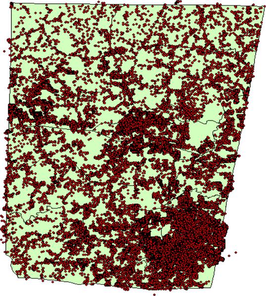
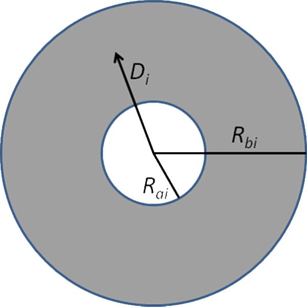
Geomasking is used to provide privacy protection for individual address information while maintaining spatial resolution for mapping purposes. Donut geomasking and other random perturbation geomasking algorithms rely on the assumption of a homogeneously distributed population to calculate displacement distances, leading to possible under-protection of individuals when this condition is not met. Using household data from 2007, we evaluated the performance of donut geomasking in Orange County, North Carolina. We calculated the estimated k-anonymity for every household based on the assumption of uniform household distribution. We then determined the actual k-anonymity by revealing household locations contained in the county E911 database. Census block groups in mixed-use areas with high population distribution heterogeneity were the most likely to have privacy protection below selected criteria. For heterogeneous populations, we suggest tripling the minimum displacement area in the donut to protect privacy with a less than 1% error rate.
Figures
References
-
- Armstrong MP, Rushton G, Zimmerman DL. Geographically masking health data to preserve confidentiality. Statist Med. 1999;18:497–525. - PubMed
-
- Armstrong MP, Ruggles AJ. Geographic information technologies and personal privacy. Cartographica. 2005;40(4):63–73.
-
- Boulos MNK, Cai Q, Padget JA, Rushton G. Using software agents to preserve individual health data confidentiality in micro-scale geographical analyses. Journal of Biomedical Informatics. 2006;39:160–170. - PubMed
-
- Brownstein JS, Cassa CA, Mandl KD. No place to hide-reverse identification of patients from published maps. N Engl J Med. 2006;355(16):1741–1742. - PubMed
Grants and funding
LinkOut - more resources
Full Text Sources
Miscellaneous