doi: 10.1371/journal.pbio.1000531.
Making marine life count: a new baseline for policy
Affiliations
- PMID: 21048985
- PMCID: PMC2964335
- DOI: 10.1371/journal.pbio.1000531
Item in Clipboard
Making marine life count: a new baseline for policy
PLoS Biol.
.
Abstract
The Census of Marine Life aids practical work of the Convention on Biological Diversity, discovers and tracks ocean biodiversity, and supports marine environmental planning.
Conflict of interest statement
The authors are members of the Census of Marine Life partnership through its Scientific Steering Committee (members and ex-officio members), International Secretariat and projects. The Public Library of Science has also received funding from the Alfred P. Sloan Foundation, to develop a Biodiversity Hub, which will feature some content from the Census of Marine Life.
Figures
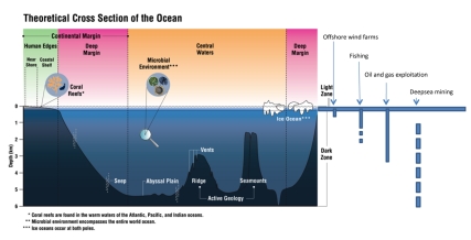
Wind farms: to 220m, plus offshore floating turbines anchored at greater depths (http://en.wikipedia.org/wiki/Wind_farm , accessed 25 May 2010). Fishing: current commercial fishing occurs between 1000 to 1400m; fishing deeper than 1500m is not constrained by technical limitations and vessels could modify equipment to suit. (F. Chopin, FAO, personal communication). Oil and gas: 3,000m (The Economist, March 4 2010). Deep-sea mining: 1,000–6,000m (Technical Study No. 2, International Seabed Authority 2002). Image: CoML and Meryl Williams.
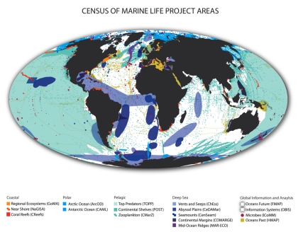
Image: CoML.
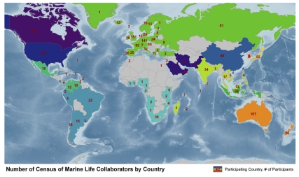
Countries coded with the same color collaborate in a regional implementation committee and numbers within country borders indicate the number of collaborating Census scientists for that country. Image: CoML
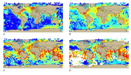
(a) total records in OBIS, corrected for differences in surface area between squares on different latitude; (b) the total number of species, corrected for differences in surface area between squares on different latitude; (c) Shannon Index; (d) Hurlbert's Index, es(50).
References
-
- O'Dor R, Acosta J, Bergstad O. A, Brainard R, Brattey J, et al. Hall J, Harrison D. E, Stammer D, editors. Bringing life to ocean observation. 2010. Proceedings of OceanObs'09: sustained ocean observations and information for society (Vol. 1), Venice, Italy, 21–25 September 2009. ESA Publication WPP-306. In press.
-
- Snelgrove P. V. R. Discoveries of the Census of Marine Life: making ocean life count. Cambridge: Cambridge University Press; 2010. p. 286 p.
-
- McIntyre A. D, editor. Life in the world's oceans: diversity, distribution and abundance. Oxford: Wiley-Blackwell; 2010. p. 384 p.
-
- PLoS Collections. Marine biodiversity and biogeography - regional comparisons of global issues. PLoS ONE. 2010 Available: http://dx.doi.org/10.1371/issue.pcol.v02.i09. Accessed 24 September 2010. - DOI - PMC - PubMed
-
- Makris N. C, Purnima R, Symonds D. T, Jagannathan S, Lee S, et al. Fish population and behavior revealed by instantaneous continental-shelf-scale imaging. Science. 2006;311:660–663. - PubMed
Publication types
MeSH terms
LinkOut - more resources
Full Text Sources