

Using remote sensing to map the risk of human monkeypox virus in the Congo Basin
- PMID: 21069425
- PMCID: PMC3237841
- DOI: 10.1007/s10393-010-0355-5
Using remote sensing to map the risk of human monkeypox virus in the Congo Basin
Abstract
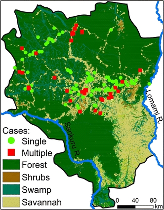
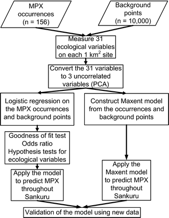
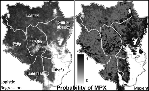
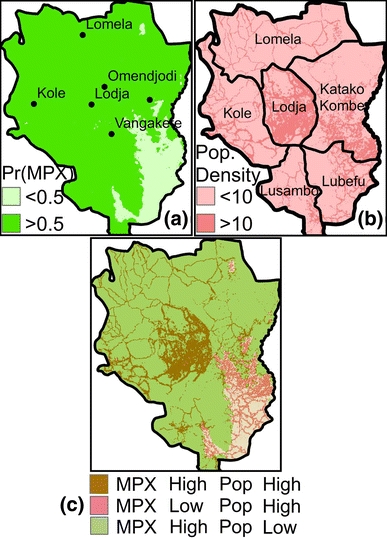
Although the incidence of human monkeypox has greatly increased in Central Africa over the last decade, resources for surveillance remain extremely limited. We conducted a geospatial analysis using existing data to better inform future surveillance efforts. Using active surveillance data collected between 2005 and 2007, we identified locations in Sankuru district, Democratic Republic of Congo (DRC) where there have been one or more cases of human monkeypox. To assess what taxa constitute the main reservoirs of monkeypox, we tested whether human cases were associated with (i) rope squirrels (Funisciurus sp.), which were implicated in monkeypox outbreaks elsewhere in the DRC in the 1980s, or (ii) terrestrial rodents in the genera Cricetomys and Graphiurus, which are believed to be monkeypox reservoirs in West Africa. Results suggest that the best predictors of human monkeypox cases are proximity to dense forests and associated habitat preferred by rope squirrels. The risk of contracting monkeypox is significantly greater near sites predicted to be habitable for squirrels (OR = 1.32; 95% CI 1.08-1.63). We recommend that semi-deciduous rainforests with oil-palm, the rope squirrel's main food source, be prioritized for monitoring.
Figures
References
-
- Aguilera AM, Escabias M, Valderrama MJ. Using principal components for estimating logistic regression with high-dimensional multicollinear data. Computational Statistics & Data Analysis. 2006;50:1905–1924. doi: 10.1016/j.csda.2005.03.011. - DOI
-
- Arino O, Bicheron P, Achard F, Latham J, Witt R, Weber J-L. GlobCover: the most detailed portrait of Earth. European Space Agency Bulletin. 2008;136:25–31.
-
- Bwangoy JRB, Hansen MC, Roy DP, De Grandi G, Justice CO. Wetland mapping in the Congo Basin using optical and radar remotely sensed data and derived topographical indices. Remote Sensing of Environment. 2010;114:73–86. doi: 10.1016/j.rse.2009.08.004. - DOI
-
- Colyn MM, Dudu A, Mbaelele MMM. Exploitation du petit et moyen gibier des forets ombrophiles du Zaire. Nature et Faune. 1987;3:22–34.
-
- Eisen RJ, Griffith KS, Borchert JN, MacMillan K, Apangu T, Owor N, et al. Assessing human risk of exposure to plague bacteria in northwestern Uganda based on remotely sensed predictors. American Journal of Tropical Medicine and Hygiene. 2010;82:904–911. doi: 10.4269/ajtmh.2010.09-0737. - DOI - PMC - PubMed
