

Malaria prevalence, risk factors and spatial distribution in a hilly forest area of Bangladesh
- PMID: 21533048
- PMCID: PMC3080915
- DOI: 10.1371/journal.pone.0018908
Malaria prevalence, risk factors and spatial distribution in a hilly forest area of Bangladesh
Abstract
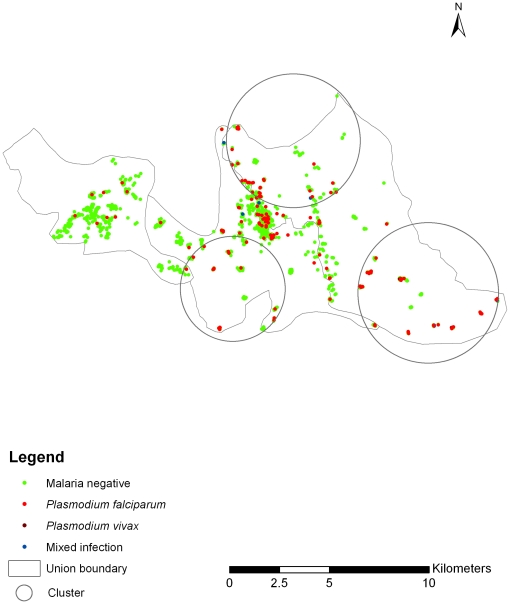
Background: Malaria is a major public health concern in Bangladesh and it is highly endemic in the Chittagong Hill Tracts where prevalence was 11.7% in 2007. One sub-district, Rajasthali, had a prevalence of 36%. Several interventions were introduced in early 2007 to control malaria. This study was undertaken to evaluate the impacts of these intensive early stage interventions on malaria in Bangladesh. This prevalence study assesses whether or not high malaria prevalence remains, and if so, which areas and individuals remain at high risk of infection.
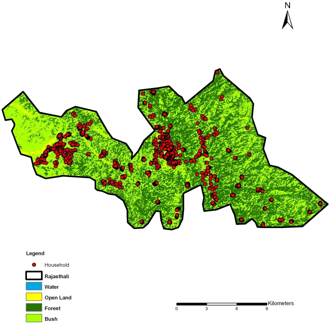
Methods and principal findings: A 2-stage cluster sampling technique was used to sample 1,400 of 5,322 (26.3%) households in Rajasthali, and screened using a rapid diagnostic test (Falci-vax). Overall malaria prevalence was 11.5%. The proportions of Plasmodium falciparum, Plasmodium vivax and infection with both species were 93.2%, 1.9% and 5.0%, respectively. Univariate, multivariate logistic regression, and spatial cluster analyses were performed separately. Sex, age, number of bed nets, forest cover, altitude and household density were potential risk factors. A statistically significant malaria cluster was identified. Significant differences among risk factors were observed between cluster and non-cluster areas.
Conclusion and significance: Malaria has significantly decreased within 2 years after onset of intervention program. Both aspects of the physical and social environment, as well as demographic characteristics are associated with spatial heterogeneity of risk. The ability to identify and locate these areas provides a strategy for targeting interventions during initial stages of intervention programs. However, in high risk clusters of transmission, even extensive coverage by current programs leaves transmission ongoing at reduced levels. This indicates the need for continued development of new strategies for identification and treatment as well as improved understanding of the patterns and determinants of parasitaemia.
Conflict of interest statement
Figures
Similar articles
-
The role of age, ethnicity and environmental factors in modulating malaria risk in Rajasthali, Bangladesh.Malar J. 2011 Dec 15;10:367. doi: 10.1186/1475-2875-10-367. Malar J. 2011. PMID: 22171950 Free PMC article.
-
High prevalence of asymptomatic malaria in south-eastern Bangladesh.Malar J. 2014 Jan 9;13:16. doi: 10.1186/1475-2875-13-16. Malar J. 2014. PMID: 24406220 Free PMC article.
-
Progress and challenges to control malaria in a remote area of Chittagong hill tracts, Bangladesh.Malar J. 2010 Jun 10;9:156. doi: 10.1186/1475-2875-9-156. Malar J. 2010. PMID: 20537127 Free PMC article.
-
Bangladesh in the era of malaria elimination.Trends Parasitol. 2023 Sep;39(9):760-773. doi: 10.1016/j.pt.2023.06.009. Epub 2023 Jul 25. Trends Parasitol. 2023. PMID: 37500334 Review.
-
An epidemiological overview of malaria in Bangladesh.Travel Med Infect Dis. 2013 Jan-Feb;11(1):29-36. doi: 10.1016/j.tmaid.2013.01.004. Epub 2013 Feb 21. Travel Med Infect Dis. 2013. PMID: 23434288 Review.
Cited by
-
Medicinal plants used by various tribes of bangladesh for treatment of malaria.Malar Res Treat. 2012;2012:371798. doi: 10.1155/2012/371798. Epub 2012 Jan 23. Malar Res Treat. 2012. PMID: 22315700 Free PMC article.
-
Malaria control in Botswana, 2008-2012: the path towards elimination.Malar J. 2013 Dec 20;12:458. doi: 10.1186/1475-2875-12-458. Malar J. 2013. PMID: 24359262 Free PMC article.
-
Dynamics of Plasmodium falciparium and Plasmodium vivax in a micro-ecological setting, Southwest Ethiopia: effects of altitude and proximity to a dam.BMC Infect Dis. 2014 Nov 19;14:625. doi: 10.1186/s12879-014-0625-x. BMC Infect Dis. 2014. PMID: 25407982 Free PMC article.
-
Spatiotemporal patterns of malaria at cross-boundaries area in Menoreh Hills, Java, Indonesia.Malar J. 2019 Mar 15;18(1):80. doi: 10.1186/s12936-019-2717-y. Malar J. 2019. PMID: 30876422 Free PMC article.
-
Cost-effective analysis of childhood malaria vaccination in endemic hotspots of Bangladesh.PLoS One. 2020 May 29;15(5):e0233902. doi: 10.1371/journal.pone.0233902. eCollection 2020. PLoS One. 2020. PMID: 32470101 Free PMC article.
References
-
- WHO. 2010. World malaria report 2010.
-
- Rahman A, Kogan F, Roytman L. Short report: Analysis of malaria cases in Bangladesh with remote sensing data. Am J of Hyg Trop Med. 2006;74(1):17–19. - PubMed
-
- M&PDC. 2010. Malaria Country Report Bangladesh - 2010.
Publication types
MeSH terms
LinkOut - more resources
Full Text Sources
Medical
