

The importance of distance to resources in the spatial modelling of bat foraging habitat
- PMID: 21547076
- PMCID: PMC3081845
- DOI: 10.1371/journal.pone.0019227
The importance of distance to resources in the spatial modelling of bat foraging habitat
Abstract
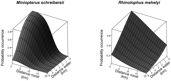
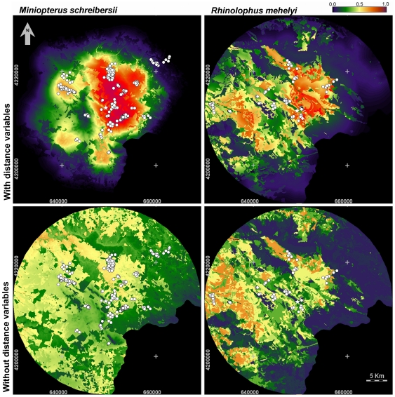
Many bats are threatened by habitat loss, but opportunities to manage their habitats are now increasing. Success of management depends greatly on the capacity to determine where and how interventions should take place, so models predicting how animals use landscapes are important to plan them. Bats are quite distinctive in the way they use space for foraging because (i) most are colonial central-place foragers and (ii) exploit scattered and distant resources, although this increases flying costs. To evaluate how important distances to resources are in modelling foraging bat habitat suitability, we radio-tracked two cave-dwelling species of conservation concern (Rhinolophus mehelyi and Miniopterus schreibersii) in a Mediterranean landscape. Habitat and distance variables were evaluated using logistic regression modelling. Distance variables greatly increased the performance of models, and distance to roost and to drinking water could alone explain 86 and 73% of the use of space by M. schreibersii and R. mehelyi, respectively. Land-cover and soil productivity also provided a significant contribution to the final models. Habitat suitability maps generated by models with and without distance variables differed substantially, confirming the shortcomings of maps generated without distance variables. Indeed, areas shown as highly suitable in maps generated without distance variables proved poorly suitable when distance variables were also considered. We concluded that distances to resources are determinant in the way bats forage across the landscape, and that using distance variables substantially improves the accuracy of suitability maps generated with spatially explicit models. Consequently, modelling with these variables is important to guide habitat management in bats and similarly mobile animals, particularly if they are central-place foragers or depend on spatially scarce resources.
Conflict of interest statement
Figures
References
-
- Mickleburgh SP, Hutson AM, Racey PA. A review of the global conservation status of bats. Oryx. 2002;36:18–34.
-
- Wickramasinghe LP, Harris S, Jones G, Vaughan N. Bat activity and species richness on organic and conventional farms: impact of agricultural intensification. J Appl Ecol. 2003;40:984–993.
-
- Wilson KA, Meijaard E, Drummond S, Grantham HS, Boitani L, et al. Conserving biodiversity in production landscapes. Ecol Appl. 2010;20:1721–1732. - PubMed
-
- Hirzel AH, Le Lay G. Habitat suitability modelling and niche theory. J Appl Ecol. 2008;45:1372–1381.
-
- Russo D, Cistrone L, Jones G, Mazzoleni S. Roost selection by barbastelle bats (Barbastella barbastellus, Chiroptera : Vespertilionidae) in beech woodlands of central Italy: consequences for conservation. Biol Conserv. 2004;117:73–81.
Publication types
MeSH terms
LinkOut - more resources
Full Text Sources
