Climatically driven biogeographic provinces of Late Triassic tropical Pangea
- PMID: 21571639
- PMCID: PMC3107300
- DOI: 10.1073/pnas.1102473108
Climatically driven biogeographic provinces of Late Triassic tropical Pangea
Abstract
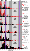
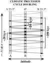
Although continents were coalesced into the single landmass Pangea, Late Triassic terrestrial tetrapod assemblages are surprisingly provincial. In eastern North America, we show that assemblages dominated by traversodont cynodonts are restricted to a humid 6° equatorial swath that persisted for over 20 million years characterized by "semiprecessional" (approximately 10,000-y) climatic fluctuations reflected in stable carbon isotopes and sedimentary facies in lacustrine strata. More arid regions from 5-20 °N preserve procolophonid-dominated faunal assemblages associated with a much stronger expression of approximately 20,000-y climatic cycles. In the absence of geographic barriers, we hypothesize that these variations in the climatic expression of astronomical forcing produced latitudinal climatic zones that sorted terrestrial vertebrate taxa, perhaps by excretory physiology, into distinct biogeographic provinces tracking latitude, not geographic position, as the proto-North American plate translated northward. Although the early Mesozoic is usually assumed to be characterized by globally distributed land animal communities due to of a lack of geographic barriers, strong provinciality was actually the norm, and nearly global communities were present only after times of massive ecological disruptions.
Conflict of interest statement
The authors declare no conflict of interest.
Figures


 , and TOC are given in the

References
-
- Frakes LA, Francis JE, Syktus JL. Climate Modes of the Phanerozoic: The History of the Earth’s Climate over the Past 600 Million Years. Cambridge, UK: Cambridge Univ Press; 1992. p. 274.
-
- Shubin NH, Sues H-D. Biogeography of early Mesozoic continental tetrapods: Patterns and implications. Paleobiology. 1991;17:214–230.
-
- Olsen PE, Galton PM. A review of the reptile and amphibian assemblages from the Stormberg of southern Africa, with special emphasis on the footprints and the age of the Stormberg. Palaeontol Afr. 1984;25:92–110.
-
- Olsen PE. Stratigraphic record of the early Mesozoic breakup of Pangea in the Laurasia-Gondwana rift system. Annu Rev Earth Planet Sci. 1997;25:337–401.
Publication types
MeSH terms
Substances
LinkOut - more resources
Full Text Sources

