

Investigating the spatial micro-epidemiology of diseases within a point-prevalence sample: a field applicable method for rapid mapping of households using low-cost GPS-dataloggers
- PMID: 21714979
- PMCID: PMC3183225
- DOI: 10.1016/j.trstmh.2011.05.007
Investigating the spatial micro-epidemiology of diseases within a point-prevalence sample: a field applicable method for rapid mapping of households using low-cost GPS-dataloggers
Abstract
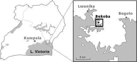
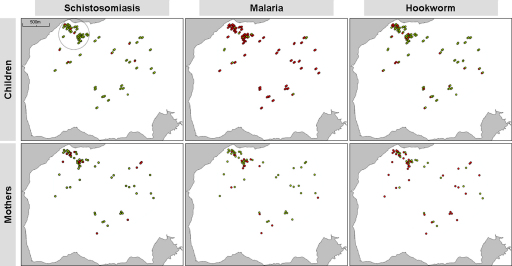
Point-prevalence recording of the distribution of tropical parasitic diseases at village level is usually sufficient for general monitoring and surveillance. Whilst within-village spatial patterning of diseases exists, and can be important, mapping infected cases in a household-by-household setting is arduous and time consuming. With the development of low-cost GPS-data loggers (< £40) and available GoogleEarth(TM) satellite imagery, we present a field-applicable method based on crowdsourcing for rapid identification of infected cases (intestinal schistosomiasis, malaria and hookworm) by household. A total of 126 mothers with their 247 preschool children from Bukoba village (Mayuge District, Uganda) were examined with half of these mothers given a GPS-data logger to walk home with, returning the unit the same day for data off-loading, after which, households were assigned GPS coordinates. A satellite image of Bukoba was annotated with households denoting the infection status of each mother and child. General prevalence of intestinal schistosomiasis, malaria and hookworm in mothers and children was: 27.2 vs 7.7%, 28.6 vs 87.0% and 60.0 vs 22.3%, respectively. Different spatial patterns of disease could be identified likely representing the intrinsic differences in parasite biology and interplay with human behaviour(s) across this local landscape providing a better insight into reasons for disease micro-patterning.
Crown Copyright © 2011. Published by Elsevier Ltd. All rights reserved.
Figures

Similar articles
-
Risk factors for Schistosoma mansoni and hookworm in urban farming communities in western Côte d'Ivoire.Trop Med Int Health. 2007 Jun;12(6):709-23. doi: 10.1111/j.1365-3156.2007.01841.x. Trop Med Int Health. 2007. PMID: 17550468
-
Influence of Schistosoma mansoni and Hookworm Infection Intensities on Anaemia in Ugandan Villages.PLoS Negl Trop Dis. 2015 Oct 29;9(10):e0004193. doi: 10.1371/journal.pntd.0004193. eCollection 2015. PLoS Negl Trop Dis. 2015. PMID: 26513151 Free PMC article.
-
Malaria, schistosomiasis, and intestinal helminths in relation to microdams in Tigray, northern Ethiopia.Parassitologia. 1998 Sep;40(3):259-67. Parassitologia. 1998. PMID: 10376281
-
Effects of improved water supply and sanitation on ascariasis, diarrhoea, dracunculiasis, hookworm infection, schistosomiasis, and trachoma.Bull World Health Organ. 1991;69(5):609-21. Bull World Health Organ. 1991. PMID: 1835675 Free PMC article. Review.
-
Epidemiology, of bilharzias (schistosomiasis) in Uganda from 1902 until 2005.Afr Health Sci. 2008 Dec;8(4):239-43. Afr Health Sci. 2008. PMID: 20589131 Free PMC article. Review.
Cited by
-
Characterizing and quantifying human movement patterns using GPS data loggers in an area approaching malaria elimination in rural southern Zambia.R Soc Open Sci. 2017 May 3;4(5):170046. doi: 10.1098/rsos.170046. eCollection 2017 May. R Soc Open Sci. 2017. PMID: 28573009 Free PMC article.
-
Characterizing mobility patterns of forest goers in southern Lao PDR using GPS loggers.Malar J. 2023 Feb 2;22(1):38. doi: 10.1186/s12936-023-04468-8. Malar J. 2023. PMID: 36732769 Free PMC article.
-
Detection of persistent Plasmodium spp. infections in Ugandan children after artemether-lumefantrine treatment.Parasitology. 2014 Dec;141(14):1880-90. doi: 10.1017/S003118201400033X. Epub 2014 May 16. Parasitology. 2014. PMID: 24837880 Free PMC article.
-
Fine-scale GPS tracking to quantify human movement patterns and exposure to leptospires in the urban slum environment.PLoS Negl Trop Dis. 2018 Aug 31;12(8):e0006752. doi: 10.1371/journal.pntd.0006752. eCollection 2018 Aug. PLoS Negl Trop Dis. 2018. PMID: 30169513 Free PMC article.
-
Closing the praziquantel treatment gap: new steps in epidemiological monitoring and control of schistosomiasis in African infants and preschool-aged children.Parasitology. 2011 Oct;138(12):1593-606. doi: 10.1017/S0031182011001235. Epub 2011 Aug 24. Parasitology. 2011. PMID: 21861945 Free PMC article. Review.
References
-
- Brooker S., Utzinger J. Integrated disease mapping in a polyparasitic world. Geospat Health. 2007;1:141–146. - PubMed
Publication types
MeSH terms
Grants and funding
LinkOut - more resources
Full Text Sources
Medical
