. 2011;6(6):e21315.
doi: 10.1371/journal.pone.0021315. Epub 2011 Jun 29.

Plasmodium falciparum malaria endemicity in Indonesia in 2010

Affiliations

Plasmodium falciparum malaria endemicity in Indonesia in 2010

Iqbal R F Elyazar et al. PLoS One. 2011.

Abstract

Background: Malaria control programs require a detailed understanding of the contemporary spatial distribution of infection risk to efficiently allocate resources. We used model based geostatistics (MBG) techniques to generate a contemporary map of Plasmodium falciparum malaria risk in Indonesia in 2010.

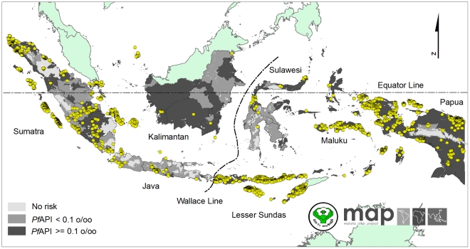
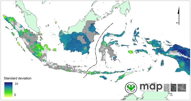
Methods: Plasmodium falciparum Annual Parasite Incidence (PfAPI) data (2006-2008) were used to map limits of P. falciparum transmission. A total of 2,581 community blood surveys of P. falciparum parasite rate (PfPR) were identified (1985-2009). After quality control, 2,516 were included into a national database of age-standardized 2-10 year old PfPR data (PfPR(2-10)) for endemicity mapping. A Bayesian MBG procedure was used to create a predicted surface of PfPR(2-10) endemicity with uncertainty estimates. Population at risk estimates were derived with reference to a 2010 human population count surface.

Results: We estimate 132.8 million people in Indonesia, lived at risk of P. falciparum transmission in 2010. Of these, 70.3% inhabited areas of unstable transmission and 29.7% in stable transmission. Among those exposed to stable risk, the vast majority were at low risk (93.39%) with the reminder at intermediate (6.6%) and high risk (0.01%). More people in western Indonesia lived in unstable rather than stable transmission zones. In contrast, fewer people in eastern Indonesia lived in unstable versus stable transmission areas.

Conclusion: While further feasibility assessments will be required, the immediate prospects for sustained control are good across much of the archipelago and medium term plans to transition to the pre-elimination phase are not unrealistic for P. falciparum. Endemicity in areas of Papua will clearly present the greatest challenge. This P. falciparum endemicity map allows malaria control agencies and their partners to comprehensively assess the region-specific prospects for reaching pre-elimination, monitor and evaluate the effectiveness of future strategies against this 2010 baseline and ultimately improve their evidence-based malaria control strategies.


Conflict of interest statement

Competing Interests: The authors have declared that no competing interests exist.

Figures

Figure 1
Figure 1. The map of Indonesian provincial administrative boundaries and their elimination objectives.
The Indonesian archipelago consists of 33 provinces and comprises seven main islands: Sumatra, Java, Kalimantan, Sulawesi, Maluku, the Lesser Sundas and Papua. The dashed lines, Wallace Line , separate the Western Indonesia (to left from the line) and Eastern Indonesia regions (to right from the line). The Indonesian elimination objectives are to be implemented in four stages: (stage 1) The thousand islands (Jakarta), Bali and Batam Islands in 2010; (stage 2) Java, Aceh and Riau Islands in 2015; (stage 3) Sumatra, West Nusa Tenggara, Kalimantan and Sulawesi in 2020 and (stage 4) Papua, West Papua, East Nusa Tenggara and Maluku Islands in 2030.
Figure 2
Figure 2. The spatial limits of Plasmodium falciparum defined by Annual Parasite Incidence and the temperature mask.
Areas were defined as stable (dark grey areas, where PfAPI≥0.1 per 1,000 pa), unstable (medium grey areas, where PfAPI<0.1 per 1,000 pa), or no risk (light grey, where PfAPI = 0 per 1,000 pa). The 2,516 community surveys of P. falciparum prevalence conducted between 01 January 1985 and 31 May 2010 are plotted.
Figure 3
Figure 3. The Plasmodium falciparum malaria PfPR2–10 endemicity map.
Model-based geostatistical point estimates of the annual mean PfPR2–10 for 2010 within the stable spatial limits of P. falciparum malaria transmission, displayed as a continuum of yellow to red from 0%–50% (see map legend). The rest of the land area was defined as unstable risk (medium grey areas, where PfAPI<0.1 per 1,000 pa) or no risk (light grey, where PfAPI = 0 per 1,000 pa).
Figure 4
Figure 4. Violin plots showing for each region frequency distributions of PfPR2–10 data.
The width of each polygon illustrates the relative frequency of different PfPR2–10 values. The background is coloured to match the endemicity classes shown in Figure 5. The black central bar indicates the inter-quartile range and white circles indicate the median values.
Figure 5
Figure 5. The Plasmodium falciparum malaria PfPR2–10 predictions stratified by endemicity class.
They are categorized as low risk (PfPR2–10≤5%), intermediate risk (5%<PfPR2–10<40%) and high risk (PfPR2–10≥40%). The rest of the land area was defined as unstable risk (medium grey areas, where PfAPI<0.1 per 1,000 pa) or no risk (light grey).
Figure 6
Figure 6. Evaluation of model performance.
(A) Scatter plot of actual versus predicted point-values of PfPR2–10. (B) Receiver-Operating-Characteristic curves for each PfPR2–10 endemicity class (PfPR2–10<5%; 5%<PfPR2–10<40%; PfPR2–10≥40%) and associated AUC statistics. (C) Probability-probability plot comparing predicted credible intervals with the actual percentage of true values lying inside those intervals. In the top and bottom plots the 1∶1 line is also shown (dashed line) for reference.
Figure 7
Figure 7. The standard deviation map of predicted PfPR2-10 within the stable transmission areas.
These values indicate an index of relative uncertainty. Dark blue areas represent where predictions were made with large uncertainty. Yellow areas represent where predictions were made with small uncertainty.
Figure 8
Figure 8. The predicted probability of PfPR2–10 falling in each endemicity class within the Plasmodium falciparum stable transmission areas.
(A) The map of predicted probability of PfPR2–10 falling in the PfPR2–10≤5% endemicity class. (B) The map of predicted probability of PfPR2–10 falling in the 5%<PfPR2–10<40% endemicity class. (C) The map of predicted probability of PfPR2–10 falling in the PfPR2–10≥40% endemicity class.

References

    1. Departemen Dalam Negeri. Jakarta, Departemen Dalam Negeri Indonesia; 2008. Kode dan data wilayah administrasi pemerintahan per provinsi, kabupaten/kota dan kecamatan seluruh Indonesia.185
    1. Badan Pusat Statistika. Data agregat per provinsi. Jakarta: Badan Pusat Statistika Indonesia; 2010. Hasil Sensus Penduduk 2010. p. 16.
    1. Takken W, Snellen WB, Verhave JP, Knols BGJ, Atmosoedjono S. Wageningen: Wageningen Agricultural University; 1990. Environmental measures for malaria control in Indonesia-An historical review on species sanitation.167
    1. Elyazar IRF, Hay SI, Baird JK. Malaria distribution, prevalence, drug resistance and control in Indonesia. Adv Parasitol. 2011;74:41–175. - PMC - PubMed
    1. Hay SI, Okiro EA, Gething PW, Patil AP, Tatem AJ, et al. Estimating the global clinical burden of Plasmodium falciparum malaria in 2007. PLoS Med. 2010;7:6. - PMC - PubMed

Publication types