Review
. 2011;6(8):e23259.
doi: 10.1371/journal.pone.0023259. Epub 2011 Aug 4.

Deep-water chemosynthetic ecosystem research during the census of marine life decade and beyond: a proposed deep-ocean road map

Collaborators, Affiliations
Review

Deep-water chemosynthetic ecosystem research during the census of marine life decade and beyond: a proposed deep-ocean road map

Christopher R German et al. PLoS One. 2011.

Abstract

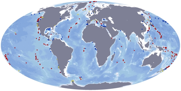
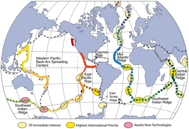
The ChEss project of the Census of Marine Life (2002-2010) helped foster internationally-coordinated studies worldwide focusing on exploration for, and characterization of new deep-sea chemosynthetic ecosystem sites. This work has advanced our understanding of the nature and factors controlling the biogeography and biodiversity of these ecosystems in four geographic locations: the Atlantic Equatorial Belt (AEB), the New Zealand region, the Arctic and Antarctic and the SE Pacific off Chile. In the AEB, major discoveries include hydrothermal seeps on the Costa Rica margin, deepest vents found on the Mid-Cayman Rise and the hottest vents found on the Southern Mid-Atlantic Ridge. It was also shown that the major fracture zones on the MAR do not create barriers for the dispersal but may act as trans-Atlantic conduits for larvae. In New Zealand, investigations of a newly found large cold-seep area suggest that this region may be a new biogeographic province. In the Arctic, the newly discovered sites on the Mohns Ridge (71 °N) showed extensive mats of sulfur-oxidisng bacteria, but only one gastropod potentially bears chemosynthetic symbionts, while cold seeps on the Haakon Mossby Mud Volcano (72 °N) are dominated by siboglinid worms. In the Antarctic region, the first hydrothermal vents south of the Polar Front were located and biological results indicate that they may represent a new biogeographic province. The recent exploration of the South Pacific region has provided evidence for a sediment hosted hydrothermal source near a methane-rich cold-seep area. Based on our 8 years of investigations of deep-water chemosynthetic ecosystems worldwide, we suggest highest priorities for future research: (i) continued exploration of the deep-ocean ridge-crest; (ii) increased focus on anthropogenic impacts; (iii) concerted effort to coordinate a major investigation of the deep South Pacific Ocean - the largest contiguous habitat for life within Earth's biosphere, but also the world's least investigated deep-ocean basin.


Conflict of interest statement

Competing Interests: The authors have declared that no competing interests exist.

Figures

Figure 1
Figure 1. ChEss field program areas.
Central map: global map showing the mid-ocean ridge and the known hydrothermal vent provinces (colour dots) known in 2002 (map modified from Van Dover et al., 2002). Highlighted regions indicate the ChEss field program areas, with priority areas (pink) and secondary areas (yellow). Priority areas: A) Atlantic Equatorial Belt; B) New Zealand region, C1) Arctic Ocean, C2) Antarctic region; D) South East Pacific/Chile Triple-Junction; Secondary areas: (a) MAR north of Iceland; (b) MAR north of Azores; (c) Brazilian margin; (d) Eastern Mediterranean; (f) SW Indian Ridge; (g) Central Indian Ridge. Arrows point to detailed maps of each priority field program area. A) AEB: (1) Equatorial MAR and fracture zones; (2) Mid-Cayman Rise; (3) Gulf of Mexico; (4) Barbados Accretionary Prism; (5) NW African margin; (6), Costa Rica margin. B) New Zealand (1) Kermadec Arc; (2) Hikurangi margin; (3) Otago margin; (4) South Island fjords. C1) Arctic basin: (1) Gakkel Ridge. C2) East Scotia Ridge, Southern Ocean: (1) E9 area; (2) E2 area; (3) Bransfield Strait. D) South East Pacific/Chile Triple Junction: (1) East Chile Rise; (2) Chile margin.
Figure 2
Figure 2. Global distribution of hydrothermal vent (red), cold seep (blue) and whale fall (yellow) sites that have been studied with respect to their fauna.
Created by M Baker and D Cuvelier, using site location data gathered from published literature or provided by researchers.
Figure 3
Figure 3. Photos showing some of the newly discovered deep-water chemosynthetic habitats found during ChEss.
A) The Beebe Vent, Piccard Hydrothermal Field on the Mid-Cayman Rise (4960 m depth), image taken by HyBIS during Voyage 44 of the RRS James Cook, April 2010 (© Jon Copley, University of Southampton/NOCS) (Connelly et al,. 2011); B, Turtle Pits hydrothermal vent, first vents discovered on the South MAR, 2005 (© ROV Quest, Marum, Bremen); C, Bubbylon hydrothermal vents on the North MAR discovered near the Azores in October 2010 (© ROV Quest, Marum, Bremen); D, Black smokers on the East Scotia Ridge south of the Polar Front discovered in January 2009 (©Paul Tyler and Jon Copley, ChEsSo Consortium, University of Southampton, UK, ROV Isis).
Figure 4
Figure 4. Annotated map (after Van Dover, 2010) of the global ridge crest, illustrating both a model of the global biogeographic differentiation of invertebrate species associated with hydrothermal vents and regions recently identified by the international community as being of continuing importance for future ridge-crest exploration.
Ellipses show three categories of importance assigned to twenty three separate locations distributed along the ridge axis (see Table 1); different coloured lines along-axis represent regions that share many of the same species (see Van Dover, 2010).
Figure 5
Figure 5. HFI* map (www.coml.org) showing how biodiversity “hot-spots” to West and East in the South Pacific are separated by areas devoid of data.
*HFI: Hurlbert's First Index is a sample-size independent proxy for species richness. Here, colours (red = high) show predicted numbers of distinct species in a random sample of 50 observations; white: areas still awaiting collection of 50+ observations!
Figure 6
Figure 6. Bathymetric projection of the South Pacific Ocean with numbered field locations as described in the text.
1, Tonga-Kermadec arc; 2, deep-ocean trenches; (3) mid-plate seamounts of the Louisville Ridge; 4 & 6, Pacific-Antarctic Ridge; 5 & 8, abyssal plains; 7, Southern EPR; 9, Chile margin; 10, Bransfield Strait back-arc basin.

References

    1. Corliss JB, Dymond J, Gordon LI, Edmond JM, von Herzen RP, et al. Submarine Thermal Springs on the Galápagos Rift. Science. 1979;203:1073–1083. - PubMed
    1. Gage J. Food inputs, utilisation, carbon flow and energetics. In: Tyler P, editor. Ecosystems of the World: Ecosystems of the Deep Ocean. Amsterdam: Elsevier; 2003. pp. 313–426.
    1. Jannasch HW, Mottl MJ. Geomicrobiology of deep-sea hydrothermal vents. Science. 1985;229:717–725. - PubMed
    1. Paull CK, Hecker B, Commeau R, Freeman-Lynde RP, Neumann C, et al. Biological communities at the Florida Escarpment resemble hydrothermal vent taxa. Science. 1984;226:965–967. - PubMed
    1. Distel DL. Phylogenetic relationships among Mytilidae (Bivalvia): 18S rRNA data suggest convergence in mytilid body plans. Molecular Phylogenetics and Evolution. 2000;15:25–33. - PubMed

Publication types