. 2011 Sep 13;108(37):E718-24.
doi: 10.1073/pnas.1107365108. Epub 2011 Aug 15.

Large-scale navigational map in a mammal

Affiliations

Large-scale navigational map in a mammal

Asaf Tsoar et al. Proc Natl Acad Sci U S A. .

Abstract

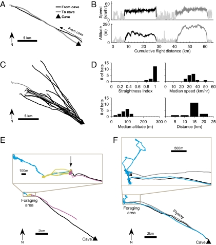
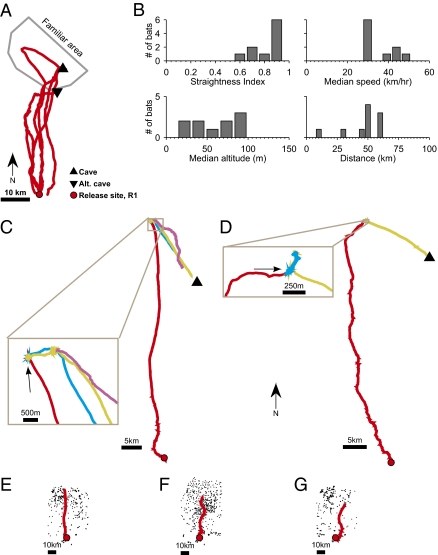
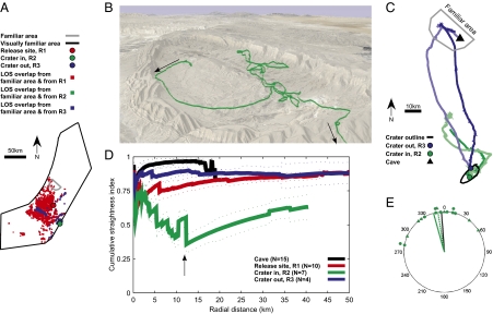
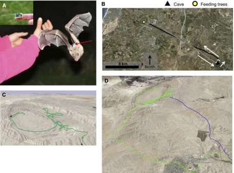
Navigation, the ability to reach desired goal locations, is critical for animals and humans. Animal navigation has been studied extensively in birds, insects, and some marine vertebrates and invertebrates, yet we are still far from elucidating the underlying mechanisms in other taxonomic groups, especially mammals. Here we report a systematic study of the mechanisms of long-range mammalian navigation. High-resolution global positioning system tracking of bats was conducted here, which revealed high, fast, and very straight commuting flights of Egyptian fruit bats (Rousettus aegyptiacus) from their cave to remote fruit trees. Bats returned to the same individual trees night after night. When displaced 44 km south, bats homed directly to one of two goal locations--familiar fruit tree or cave--ruling out beaconing, route-following, or path-integration mechanisms. Bats released 84 km south, within a deep natural crater, were initially disoriented (but eventually left the crater toward the home direction and homed successfully), whereas bats released at the crater-edge top homed directly, suggesting navigation guided primarily by distal visual landmarks. Taken together, these results provide evidence for a large-scale "cognitive map" that enables navigation of a mammal within its visually familiar area, and they also demonstrate the ability to home back when translocated outside the visually familiar area.


Conflict of interest statement

The authors declare no conflict of interest.

Figures

Fig. 1.
Fig. 1.
GPS tracking of Egyptian fruit bats navigating from their cave. (A) Example of bat 125 leaving the cave, flying locally (light gray line), then taking a long commuting flight to the feeding tree (black line) and back to the cave (dark gray). (B) Speed and altitude above ground level for the same bat as in A as function of its cumulative flight distance during the night. Black, commuting flight from cave; dark gray, back to cave. (C) All commuting flights that started or ended directly at the cave (n = 14); colors as in A; note the very straight flights of all these bats. An additional seven flights were composed of a local flight and then a commuting flight (e.g., the bat in A); their commuting flights were as straight as those depicted here. (D) Flight parameters for the commuting flights of all bats released at the cave (n = 15): shown are straightness index, median speed, median altitude above ground level, and total flight distance to the first feeding tree. (E and F) Bats returned to the same individual tree night after night. Bottom: Full flight path; Top (Inset): Zoom-in view of the feeding trees; colors represent different consecutive nights. (E) Bat 213 returned over four consecutive nights to the same Prunus armeniaca tree (arrow). (F) Bat 243 returned over two nights to the same two trees; note the commuting flyway; black and gray lines represent flight to and from the foraging area on night one.
Fig. 2.
Fig. 2.
Translocation experiments indicate strong homing capacity of Egyptian fruit bats. (A) Homing flights of all bats that homed from release site R1 directly to the cave or to a nearby alternate cave. (B) Flight parameters of all bats (both bats that homed to the cave as in A and bats that flew to trees as in C–G; n = 10); same notation as in Fig. 1D. (C and D) Examples of bats that flew from release site R1 to a tree, and then returned to the same individual tree night after night; colors represent different nights. (C) Bat 230 flew to a Morus alba tree (Inset, arrow) for three consecutive nights. (D) Bat 160 flew to a Diospyros kaki tree (arrow) for three consecutive nights. (EG) Bats flew to a particular tree (and subsequently returned to the same tree night after night) while ignoring many other trees of the same species on the way (black dots). (E) Bat 230 flew to a M. alba tree. (F) Bat 191 flew to a Ceratonia siliqua tree. (G) Bat 232 flew to a Eriobotrya japonica tree.
Fig. 3.
Fig. 3.
Bat navigation relies primarily but not exclusively on distal visual landmarks. (A) Line-of-sight calculations: large black polygon represents the visually familiar area, as seen from the highest recorded altitude of bats’ flights (643 m above ground level); small gray polygon represents the familiar area physically visited by foraging bats (Methods). Red squares mark locations seen both from the familiar area (near cave) and from release site R1 (at the highest recorded flight altitude of 115 m). Blue squares represent the same for release site R3 (at the highest flight altitude of 74 m). Note absence of green squares, indicating that bats released within the crater (R2), flying at the highest recorded altitude of 101 m, could not see any familiar visual landmarks. (B) Example of bat 259, released inside the crater; note the tortuous disoriented flight: this bat flew 33.9 km before it left the crater and turned northeast, then northwest toward the familiar area. View from the northeast. (C) Homing flight of two bats (bats 259 and 274, green lines) released inside the crater and two bats (bats 317 and 318, blue lines) released high on the crater rim; light-gray polygon represents the familiar area of the bats. Note that bats released at the crater rim flew north much straighter than bats released inside the crater. (D) Population data showing cumulative straightness index as function of distance from the release site; the four colors represent bats released at the four different release locations (cave, R1, R2, and R3); dotted lines represent median ± SE of the median; shown are only the distances with data from at least three bats. Note the substantially lower cumulative straightness index for within-crater releases (green), indicating strong disorientation when distal landmarks are not visible. (E) Polar display of bats’ vanishing bearings (green circles) and the direction of the bats’ exit points from the crater (triangles) after release at point R2 (inside crater). Green solid and dotted lines represent average directions of the circles and triangles, respectively; black line represents homeward direction (to cave).
Fig. P1.
Fig. P1.
(A) GPS device placed on the back of an Egyptian fruit bats. Photo credit: A. Tsoar. (B) Flight trajectory of a bat leaving the cave, flying locally (light gray line), then taking a long commuting flight to the feeding tree (black line) and then back to the cave (dark gray). Bats flew at very straight trajectories, and returned to the same favorite feeding-trees night after night. (C) Bat that was released in the Negev desert in Israel, inside a deep erosional crater that is surrounded by cliffs approximately 300-m high. Note the tortuous disoriented flight (green): this bat flew almost 34 km before it eventually left the crater and turned toward the familiar area. (D) Bats that were released from a high mountain at the crater edge have homed straight (blue line), in contrast to the disoriented flights of bats released inside the crater (green), suggesting an important role for vision in Egyptian fruit bat navigation. C, view from northeast; D, view from north-northeast.

Comment in

  • A bat's perspective on navigation.
    Moser EI. Moser EI. Proc Natl Acad Sci U S A. 2011 Sep 20;108(38):15665-6. doi: 10.1073/pnas.1112843108. Epub 2011 Sep 8. Proc Natl Acad Sci U S A. 2011. PMID: 21903921 Free PMC article. No abstract available.

References

    1. Wallraff HG. Avian Navigation: Pigeon Homing as a Paradigm. New York: Springer; 2005.
    1. Gallistel CR. The Organization of Learning. Cambridge, MA: MIT Press; 1990.
    1. Menzel R, et al. Honey bees navigate according to a map-like spatial memory. Proc Natl Acad Sci USA. 2005;102:3040–3045. - PMC - PubMed
    1. Lohmann KJ, Lohmann CM, Ehrhart LM, Bagley DA, Swing T. Animal behaviour: geomagnetic map used in sea-turtle navigation. Nature. 2004;428:909–910. - PubMed
    1. Cochran WW, Mouritsen H, Wikelski M. Migrating songbirds recalibrate their magnetic compass daily from twilight cues. Science. 2004;304:405–408. - PubMed

Publication types

LinkOut - more resources