

Spatially explicit multi-criteria decision analysis for managing vector-borne diseases
- PMID: 22206355
- PMCID: PMC3315429
- DOI: 10.1186/1476-072X-10-70
Spatially explicit multi-criteria decision analysis for managing vector-borne diseases
Abstract
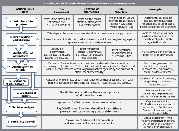
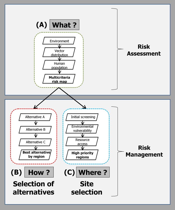
The complex epidemiology of vector-borne diseases creates significant challenges in the design and delivery of prevention and control strategies, especially in light of rapid social and environmental changes. Spatial models for predicting disease risk based on environmental factors such as climate and landscape have been developed for a number of important vector-borne diseases. The resulting risk maps have proven value for highlighting areas for targeting public health programs. However, these methods generally only offer technical information on the spatial distribution of disease risk itself, which may be incomplete for making decisions in a complex situation. In prioritizing surveillance and intervention strategies, decision-makers often also need to consider spatially explicit information on other important dimensions, such as the regional specificity of public acceptance, population vulnerability, resource availability, intervention effectiveness, and land use. There is a need for a unified strategy for supporting public health decision making that integrates available data for assessing spatially explicit disease risk, with other criteria, to implement effective prevention and control strategies. Multi-criteria decision analysis (MCDA) is a decision support tool that allows for the consideration of diverse quantitative and qualitative criteria using both data-driven and qualitative indicators for evaluating alternative strategies with transparency and stakeholder participation. Here we propose a MCDA-based approach to the development of geospatial models and spatially explicit decision support tools for the management of vector-borne diseases. We describe the conceptual framework that MCDA offers as well as technical considerations, approaches to implementation and expected outcomes. We conclude that MCDA is a powerful tool that offers tremendous potential for use in public health decision-making in general and vector-borne disease management in particular.
Figures
Similar articles
-
Adaptation and Evaluation of a Multi-Criteria Decision Analysis Model for Lyme Disease Prevention.PLoS One. 2015 Aug 21;10(8):e0135171. doi: 10.1371/journal.pone.0135171. eCollection 2015. PLoS One. 2015. PMID: 26295344 Free PMC article.
-
Multi-criteria decision analysis as an innovative approach to managing zoonoses: results from a study on Lyme disease in Canada.BMC Public Health. 2013 Sep 30;13:897. doi: 10.1186/1471-2458-13-897. BMC Public Health. 2013. PMID: 24079303 Free PMC article.
-
Spatial multi-criteria decision analysis for the selection of sentinel regions in tick-borne disease surveillance.BMC Public Health. 2024 Jan 25;24(1):294. doi: 10.1186/s12889-024-17684-x. BMC Public Health. 2024. PMID: 38267914 Free PMC article.
-
From comparative risk assessment to multi-criteria decision analysis and adaptive management: recent developments and applications.Environ Int. 2006 Dec;32(8):1072-93. doi: 10.1016/j.envint.2006.06.013. Epub 2006 Aug 14. Environ Int. 2006. PMID: 16905190 Review.
-
Multiple Criteria Decision Analysis for Health Care Decision Making--Emerging Good Practices: Report 2 of the ISPOR MCDA Emerging Good Practices Task Force.Value Health. 2016 Mar-Apr;19(2):125-37. doi: 10.1016/j.jval.2015.12.016. Epub 2016 Mar 7. Value Health. 2016. PMID: 27021745 Review.
Cited by
-
Fine-scale mapping of urban malaria exposure under data scarcity: an approach centred on vector ecology.Malar J. 2023 Apr 3;22(1):113. doi: 10.1186/s12936-023-04527-0. Malar J. 2023. PMID: 37009873 Free PMC article.
-
Assessing the social vulnerability to malaria in Rwanda.Malar J. 2015 Jan 7;14:2. doi: 10.1186/1475-2875-14-2. Malar J. 2015. PMID: 25566988 Free PMC article.
-
Quantitative assessment of a spatial multicriteria model for highly pathogenic avian influenza H5N1 in Thailand, and application in Cambodia.Sci Rep. 2016 Aug 4;6:31096. doi: 10.1038/srep31096. Sci Rep. 2016. PMID: 27489997 Free PMC article.
-
Spatial Multicriteria Evaluation for Mapping the Risk of Occurrence of Peste des Petits Ruminants in Eastern Africa and the Union of the Comoros.Front Vet Sci. 2019 Dec 12;6:455. doi: 10.3389/fvets.2019.00455. eCollection 2019. Front Vet Sci. 2019. PMID: 31921913 Free PMC article.
-
Integrated Social-Behavioral and Ecological Risk Maps to Prioritize Local Public Health Responses to Lyme Disease.Environ Health Perspect. 2018 Apr 18;126(4):047008. doi: 10.1289/EHP1943. Environ Health Perspect. 2018. PMID: 29671475 Free PMC article.
References
-
- Pavlovsky EN. Natural Nidality of Transmissible Diseases with special reference to the Landscape Epidemiology of Zooanthroponoses. University of Illinois Press. Urbana; 1966.
-
- Rogers DJ. In: Advances in Parasitology. Simon I, Hay AG, David JR, editor. Vol. 62. Academic Press; 2006. Models for Vectors and Vector-Borne Diseases; pp. 1–35. - PubMed
Publication types
MeSH terms
LinkOut - more resources
Full Text Sources
Other Literature Sources
