

Large-scale spatial population databases in infectious disease research
- PMID: 22433126
- PMCID: PMC3331802
- DOI: 10.1186/1476-072X-11-7
Large-scale spatial population databases in infectious disease research
Abstract
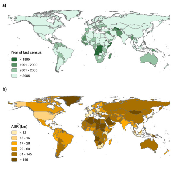
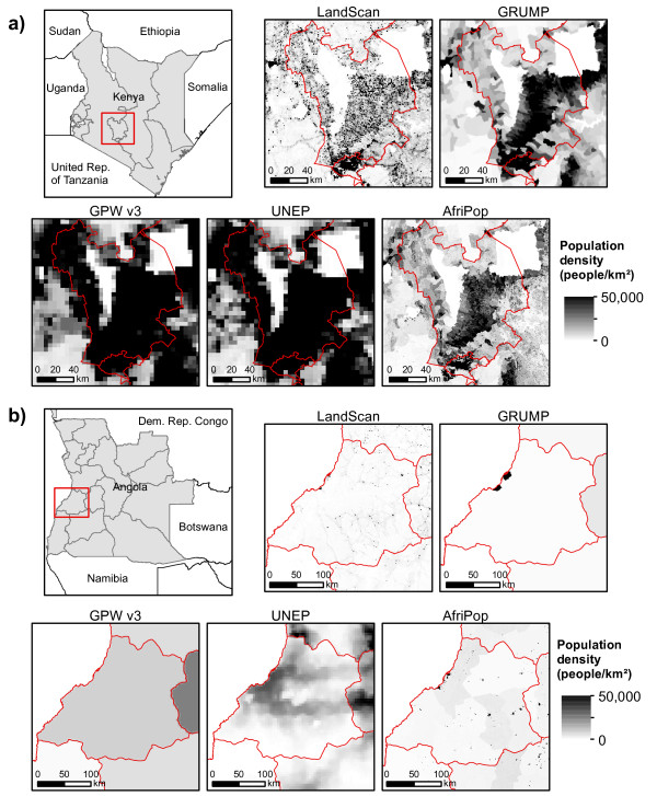
Modelling studies on the spatial distribution and spread of infectious diseases are becoming increasingly detailed and sophisticated, with global risk mapping and epidemic modelling studies now popular. Yet, in deriving populations at risk of disease estimates, these spatial models must rely on existing global and regional datasets on population distribution, which are often based on outdated and coarse resolution data. Moreover, a variety of different methods have been used to model population distribution at large spatial scales. In this review we describe the main global gridded population datasets that are freely available for health researchers and compare their construction methods, and highlight the uncertainties inherent in these population datasets. We review their application in past studies on disease risk and dynamics, and discuss how the choice of dataset can affect results. Moreover, we highlight how the lack of contemporary, detailed and reliable data on human population distribution in low income countries is proving a barrier to obtaining accurate large-scale estimates of population at risk and constructing reliable models of disease spread, and suggest research directions required to further reduce these barriers.
© 2012 Linard and Tatem; licensee BioMed Central Ltd.
Figures
Similar articles
-
The effects of spatial population dataset choice on estimates of population at risk of disease.Popul Health Metr. 2011 Feb 7;9:4. doi: 10.1186/1478-7954-9-4. Popul Health Metr. 2011. PMID: 21299885 Free PMC article.
-
A high resolution spatial population database of Somalia for disease risk mapping.Int J Health Geogr. 2010 Sep 14;9:45. doi: 10.1186/1476-072X-9-45. Int J Health Geogr. 2010. PMID: 20840751 Free PMC article.
-
Mapping populations at risk: improving spatial demographic data for infectious disease modeling and metric derivation.Popul Health Metr. 2012 May 16;10(1):8. doi: 10.1186/1478-7954-10-8. Popul Health Metr. 2012. PMID: 22591595 Free PMC article.
-
A brief review of spatial analysis concepts and tools used for mapping, containment and risk modelling of infectious diseases and other illnesses.Parasitology. 2014 Apr;141(5):581-601. doi: 10.1017/S0031182013001972. Epub 2013 Dec 13. Parasitology. 2014. PMID: 24476672 Review.
-
Climate forcing and infectious disease transmission in urban landscapes: integrating demographic and socioeconomic heterogeneity.Ann N Y Acad Sci. 2016 Oct;1382(1):44-55. doi: 10.1111/nyas.13229. Epub 2016 Sep 28. Ann N Y Acad Sci. 2016. PMID: 27681053 Review.
Cited by
-
Zoom in at African country level: potential climate induced changes in areas of suitability for survival of malaria vectors.Int J Health Geogr. 2014 May 7;13:12. doi: 10.1186/1476-072X-13-12. Int J Health Geogr. 2014. PMID: 24885061 Free PMC article.
-
Generalized Vertical Components of built-up areas from global Digital Elevation Models by multi-scale linear regression modelling.PLoS One. 2021 Feb 10;16(2):e0244478. doi: 10.1371/journal.pone.0244478. eCollection 2021. PLoS One. 2021. PMID: 33566815 Free PMC article.
-
Modifiable Areal Unit Problems for Infectious Disease Cases Described in Medicare and Medicaid Claims, 2016-2019.J Bacteriol Parasitol. 2024;15(Suppl 27):98. Epub 2024 May 13. J Bacteriol Parasitol. 2024. PMID: 39726736 Free PMC article.
-
High resolution population distribution maps for Southeast Asia in 2010 and 2015.PLoS One. 2013;8(2):e55882. doi: 10.1371/journal.pone.0055882. Epub 2013 Feb 13. PLoS One. 2013. PMID: 23418469 Free PMC article.
-
Gridded Population Maps Informed by Different Built Settlement Products.Data (Basel). 2018 Sep 4;3:33. doi: 10.3390/data3030033. Data (Basel). 2018. PMID: 33344538 Free PMC article.
References
Publication types
MeSH terms
Grants and funding
LinkOut - more resources
Full Text Sources
Medical
Miscellaneous
