Review
doi: 10.4269/ajtmh.2012.11-0650.
Geographical information systems for dengue surveillance
Affiliations
- PMID: 22556070
- PMCID: PMC3335676
- DOI: 10.4269/ajtmh.2012.11-0650
Item in Clipboard
Review
Geographical information systems for dengue surveillance
Am J Trop Med Hyg.
2012 May.
Abstract
This review provides details on the role of Geographical Information Systems (GIS) in current dengue surveillance systems and focuses on the application of open access GIS technology to emphasize its importance in developing countries, where the dengue burden is greatest. It also advocates for increased international collaboration in transboundary disease surveillance to confront the emerging global challenge of dengue.
Figures
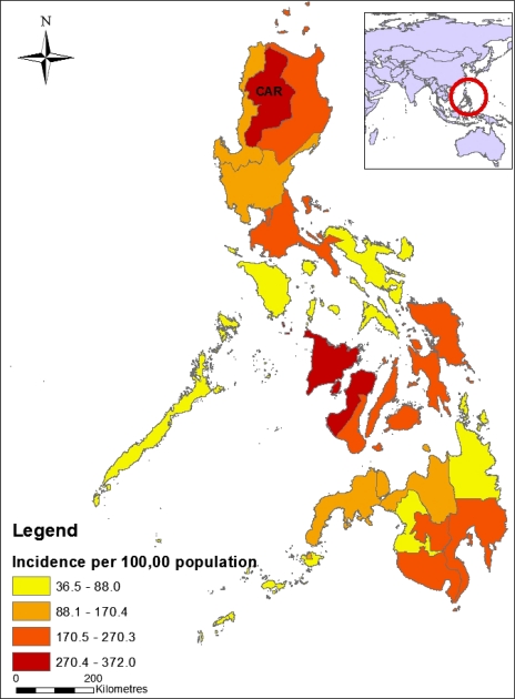
Dengue incidence by administrative region in the Philippines in 2010. Data sources: National Statistics Office (Philippines) and National Epidemiology Centre, Department of Health (Philippines).
Comment in
-
GIS for dengue surveillance: strengthening collaborations.Am J Trop Med Hyg. 2012 Dec;87(6):1152. doi: 10.4269/ajtmh.2012.12-0309a. Am J Trop Med Hyg. 2012. PMID: 23222139 Free PMC article. No abstract available.
References
-
- World Health Organization . Dengue Guidelines for Diagnosis, Treatment, Prevention and Control. 2009. http://whqlibdoc.who.int/publications/2009/9789241547871_eng.pdf Available at. Accessed July 13, 2011. - PubMed
Publication types
MeSH terms
LinkOut - more resources
Full Text Sources
Medical