

Opuntia in México: identifying priority areas for conserving biodiversity in a multi-use landscape
- PMID: 22606279
- PMCID: PMC3351470
- DOI: 10.1371/journal.pone.0036650
Opuntia in México: identifying priority areas for conserving biodiversity in a multi-use landscape
Abstract
Background: México is one of the world's centers of species diversity (richness) for Opuntia cacti. Yet, in spite of their economic and ecological importance, Opuntia species remain poorly studied and protected in México. Many of the species are sparsely but widely distributed across the landscape and are subject to a variety of human uses, so devising implementable conservation plans for them presents formidable difficulties. Multi-criteria analysis can be used to design a spatially coherent conservation area network while permitting sustainable human usage.
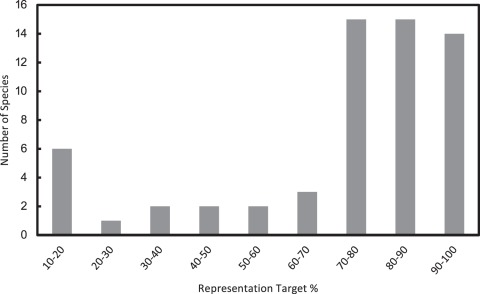
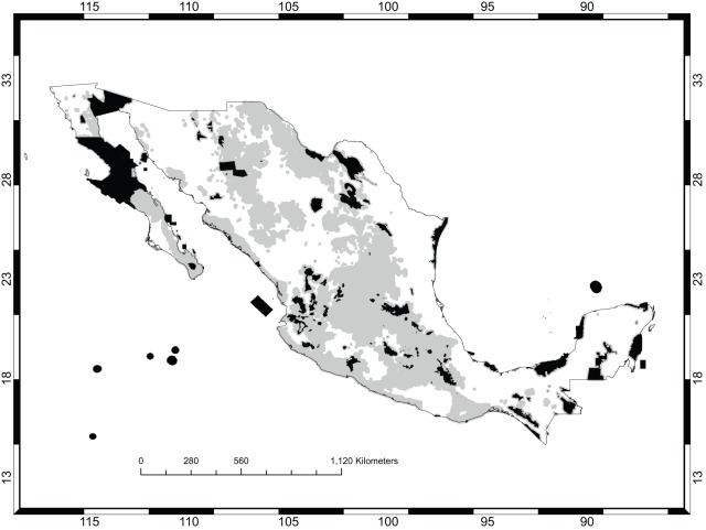
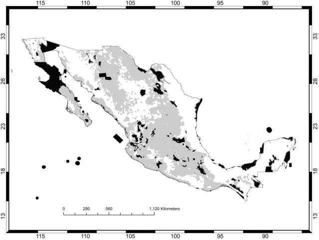
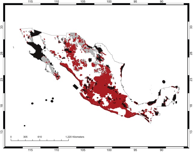
Methods and findings: Species distribution models were created for 60 Opuntia species using MaxEnt. Targets of representation within conservation area networks were assigned at 100% for the geographically rarest species and 10% for the most common ones. Three different conservation plans were developed to represent the species within these networks using total area, shape, and connectivity as relevant criteria. Multi-criteria analysis and a metaheuristic adaptive tabu search algorithm were used to search for optimal solutions. The plans were built on the existing protected areas of México and prioritized additional areas for management for the persistence of Opuntia species. All plans required around one-third of México's total area to be prioritized for attention for Opuntia conservation, underscoring the implausibility of Opuntia conservation through traditional land reservation. Tabu search turned out to be both computationally tractable and easily implementable for search problems of this kind.
Conclusions: Opuntia conservation in México require the management of large areas of land for multiple uses. The multi-criteria analyses identified priority areas and organized them in large contiguous blocks that can be effectively managed. A high level of connectivity was established among the prioritized areas resulting in the enhancement of possible modes of plant dispersal as well as only a small number of blocks that would be recommended for conservation management.
Conflict of interest statement
Figures

References
-
- Margules CR, Pressey RL. Systematic conservation planning. Nature. 2000;405:245–253. - PubMed
-
- Margules CR, Sarkar S. Cambridge, UK: Cambridge University Press; 2007. Systematic Conservation Planning.
-
- Sarkar S, Montoya M. Beyond Parks and Reserves: The Ethics and Politics of Conservation with a Case Study from Perú. Biological Conservation. 2011;144:979–988.
-
- Sarkar S, Margules CR. Operationalizing biodiversity for conservation planning. Journal of Biosciences. 2002;27(S2):299–308. - PubMed
-
- Sarkar S. Cambridge, UK: Cambridge University Press; 2005. Biodiversity and Environmental Philosophy: An Introduction to the Issues.
Publication types
MeSH terms
LinkOut - more resources
Full Text Sources
