

Systematic social observation of children's neighborhoods using Google Street View: a reliable and cost-effective method
- PMID: 22676812
- PMCID: PMC3537178
- DOI: 10.1111/j.1469-7610.2012.02565.x
Systematic social observation of children's neighborhoods using Google Street View: a reliable and cost-effective method
Abstract
Background: Children growing up in poor versus affluent neighborhoods are more likely to spend time in prison, develop health problems and die at an early age. The question of how neighborhood conditions influence our behavior and health has attracted the attention of public health officials and scholars for generations. Online tools are now providing new opportunities to measure neighborhood features and may provide a cost effective way to advance our understanding of neighborhood effects on child health.
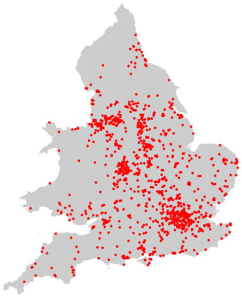
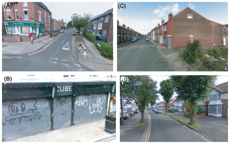
Method: A virtual systematic social observation (SSO) study was conducted to test whether Google Street View could be used to reliably capture the neighborhood conditions of families participating in the Environmental-Risk (E-Risk) Longitudinal Twin Study. Multiple raters coded a subsample of 120 neighborhoods and convergent and discriminant validity was evaluated on the full sample of over 1,000 neighborhoods by linking virtual SSO measures to: (a) consumer based geo-demographic classifications of deprivation and health, (b) local resident surveys of disorder and safety, and (c) parent and teacher assessments of children's antisocial behavior, prosocial behavior, and body mass index.
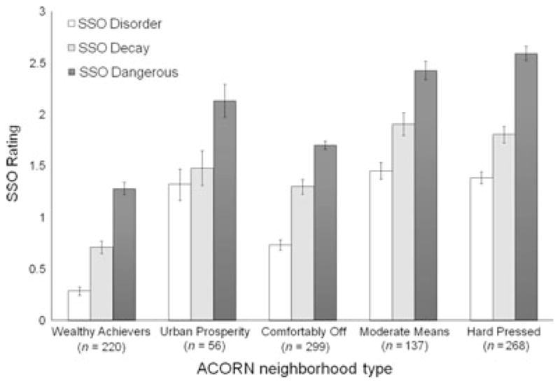
Results: High levels of observed agreement were documented for signs of physical disorder, physical decay, dangerousness and street safety. Inter-rater agreement estimates fell within the moderate to substantial range for all of the scales (ICCs ranged from .48 to .91). Negative neighborhood features, including SSO-rated disorder and decay and dangerousness corresponded with local resident reports, demonstrated a graded relationship with census-defined indices of socioeconomic status, and predicted higher levels of antisocial behavior among local children. In addition, positive neighborhood features, including SSO-rated street safety and the percentage of green space, were associated with higher prosocial behavior and healthy weight status among children.
Conclusions: Our results support the use of Google Street View as a reliable and cost effective tool for measuring both negative and positive features of local neighborhoods.
© 2012 The Authors. Journal of Child Psychology and Psychiatry © 2012 Association for Child and Adolescent Mental Health.
Conflict of interest statement
Conflict of interest statement:
The authors declare no conflicts of interest. Candice L. Odgers had full access to all the data and takes responsibility for the integrity of the data and the accuracy of the data analysis.
The authors have declared that they have no competing or potential conflicts of interest.
Figures
Similar articles
-
A Reliable, Feasible Method to Observe Neighborhoods at High Spatial Resolution.Am J Prev Med. 2017 Jan;52(1S1):S20-S30. doi: 10.1016/j.amepre.2016.06.010. Am J Prev Med. 2017. PMID: 27989289 Free PMC article.
-
Supportive parenting mediates neighborhood socioeconomic disparities in children's antisocial behavior from ages 5 to 12.Dev Psychopathol. 2012 Aug;24(3):705-21. doi: 10.1017/S0954579412000326. Dev Psychopathol. 2012. PMID: 22781850 Free PMC article.
-
Neighborhood conditions in a Swedish context-Two studies of reliability and validity of virtual systematic social observation using Google Street View.Front Psychol. 2023 Jan 27;14:1020742. doi: 10.3389/fpsyg.2023.1020742. eCollection 2023. Front Psychol. 2023. PMID: 36777218 Free PMC article.
-
Folic acid supplementation and malaria susceptibility and severity among people taking antifolate antimalarial drugs in endemic areas.Cochrane Database Syst Rev. 2022 Feb 1;2(2022):CD014217. doi: 10.1002/14651858.CD014217. Cochrane Database Syst Rev. 2022. PMID: 36321557 Free PMC article.
-
Emerging technologies to measure neighborhood conditions in public health: implications for interventions and next steps.Int J Health Geogr. 2016 Jun 23;15(1):20. doi: 10.1186/s12942-016-0050-z. Int J Health Geogr. 2016. PMID: 27339260 Free PMC article. Review.
Cited by
-
Impulse Control and Callous-Unemotional Traits Distinguish Patterns of Delinquency and Substance Use in Justice Involved Adolescents: Examining the Moderating Role of Neighborhood Context.J Abnorm Child Psychol. 2016 Apr;44(3):599-611. doi: 10.1007/s10802-015-0057-0. J Abnorm Child Psychol. 2016. PMID: 26201308
-
Bullying behaviours and other conduct problems: longitudinal investigation of their independent associations with risk factors and later outcomes.Soc Psychiatry Psychiatr Epidemiol. 2021 Nov;56(11):2041-2052. doi: 10.1007/s00127-021-02062-4. Epub 2021 Apr 15. Soc Psychiatry Psychiatr Epidemiol. 2021. PMID: 33856493 Free PMC article.
-
Stress and adolescent well-being: the need for an interdisciplinary framework.Health Promot Int. 2017 Dec 1;32(6):1081-1090. doi: 10.1093/heapro/daw038. Health Promot Int. 2017. PMID: 27153917 Free PMC article.
-
Translating multilevel theory into multilevel research: challenges and opportunities for understanding the social determinants of psychiatric disorders.Soc Psychiatry Psychiatr Epidemiol. 2014 Jun;49(6):859-72. doi: 10.1007/s00127-013-0809-5. Epub 2014 Jan 28. Soc Psychiatry Psychiatr Epidemiol. 2014. PMID: 24469555 Free PMC article.
-
Optimizing Scoring and Sampling Methods for Assessing Built Neighborhood Environment Quality in Residential Areas.Int J Environ Res Public Health. 2017 Mar 8;14(3):273. doi: 10.3390/ijerph14030273. Int J Environ Res Public Health. 2017. PMID: 28282878 Free PMC article.
References
-
- Achenbach TM. Manual for the child behavior checklist/4–18 and 1991 profile. Burlington: University of Vermont Department of Psychiatry; 1991a.
-
- Achenbach TM. Manual for the teacher’s report form and 1991 profile. Burlington: University of Vermont Department of Psychiatry; 1991b.
-
- Booth C. Labour and life of the people. Vol. 2. London: Williams and Norgate; 1891.
-
- Chen E, Paterson LQ. Neighborhood, family, and subjective socioeconomic status: How do they relate to adolescent health? Health Psychology. 2006;25:704–714. - PubMed
