"Right time, right place" health communication on Twitter: value and accuracy of location information
- PMID: 23154246
- PMCID: PMC3510712
- DOI: 10.2196/jmir.2121
"Right time, right place" health communication on Twitter: value and accuracy of location information
Abstract
Background: Twitter provides various types of location data, including exact Global Positioning System (GPS) coordinates, which could be used for infoveillance and infodemiology (ie, the study and monitoring of online health information), health communication, and interventions. Despite its potential, Twitter location information is not well understood or well documented, limiting its public health utility.
Objective: The objective of this study was to document and describe the various types of location information available in Twitter. The different types of location data that can be ascertained from Twitter users are described. This information is key to informing future research on the availability, usability, and limitations of such location data.
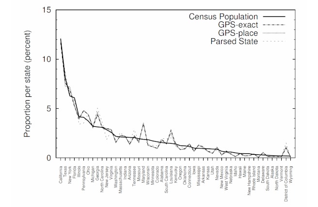
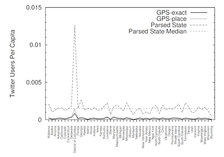
Methods: Location data was gathered directly from Twitter using its application programming interface (API). The maximum tweets allowed by Twitter were gathered (1% of the total tweets) over 2 separate weeks in October and November 2011. The final dataset consisted of 23.8 million tweets from 9.5 million unique users. Frequencies for each of the location options were calculated to determine the prevalence of the various location data options by region of the world, time zone, and state within the United States. Data from the US Census Bureau were also compiled to determine population proportions in each state, and Pearson correlation coefficients were used to compare each state's population with the number of Twitter users who enable the GPS location option.
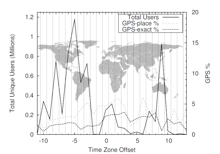
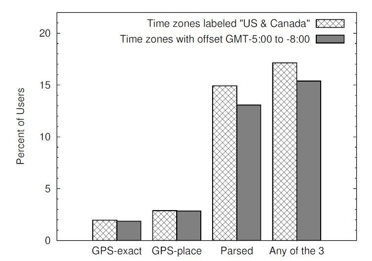
Results: The GPS location data could be ascertained for 2.02% of tweets and 2.70% of unique users. Using a simple text-matching approach, 17.13% of user profiles in the 4 continental US time zones were able to be used to determine the user's city and state. Agreement between GPS data and data from the text-matching approach was high (87.69%). Furthermore, there was a significant correlation between the number of Twitter users per state and the 2010 US Census state populations (r ≥ 0.97, P < .001).
Conclusions: Health researchers exploring ways to use Twitter data for disease surveillance should be aware that the majority of tweets are not currently associated with an identifiable geographic location. Location can be identified for approximately 4 times the number of tweets using a straightforward text-matching process compared to using the GPS location information available in Twitter. Given the strong correlation between both data gathering methods, future research may consider using more qualitative approaches with higher yields, such as text mining, to acquire information about Twitter users' geographical location.
Conflict of interest statement
None declared.
Figures
Similar articles
-
Electronic word of mouth on twitter about physical activity in the United States: exploratory infodemiology study.J Med Internet Res. 2013 Nov 20;15(11):e261. doi: 10.2196/jmir.2870. J Med Internet Res. 2013. PMID: 24257325 Free PMC article.
-
Monitoring Physical Activity Levels Using Twitter Data: Infodemiology Study.J Med Internet Res. 2019 Jun 3;21(6):e12394. doi: 10.2196/12394. J Med Internet Res. 2019. PMID: 31162126 Free PMC article.
-
Mapping tweets to a known disease epidemiology; a case study of Lyme disease in the United Kingdom and Republic of Ireland.J Biomed Inform. 2019;100S:100060. doi: 10.1016/j.yjbinx.2019.100060. Epub 2019 Oct 18. J Biomed Inform. 2019. PMID: 34384577
-
#TreatmentResistantDepression: A qualitative content analysis of Tweets about difficult-to-treat depression.Health Expect. 2023 Oct;26(5):1986-1996. doi: 10.1111/hex.13807. Epub 2023 Jun 23. Health Expect. 2023. PMID: 37350377 Free PMC article. Review.
-
Are Health-Related Tweets Evidence Based? Review and Analysis of Health-Related Tweets on Twitter.J Med Internet Res. 2015 Oct 29;17(10):e246. doi: 10.2196/jmir.4898. J Med Internet Res. 2015. PMID: 26515535 Free PMC article. Review.
Cited by
-
Use of social media big data as a novel HIV surveillance tool in South Africa.PLoS One. 2020 Oct 2;15(10):e0239304. doi: 10.1371/journal.pone.0239304. eCollection 2020. PLoS One. 2020. PMID: 33006979 Free PMC article.
-
Using Google Location History data to quantify fine-scale human mobility.Int J Health Geogr. 2018 Jul 27;17(1):28. doi: 10.1186/s12942-018-0150-z. Int J Health Geogr. 2018. PMID: 30049275 Free PMC article.
-
Leveraging geotagged Twitter data to examine neighborhood happiness, diet, and physical activity.Appl Geogr. 2016 Aug;73:77-88. doi: 10.1016/j.apgeog.2016.06.003. Epub 2016 Jul 1. Appl Geogr. 2016. PMID: 28533568 Free PMC article.
-
Design and analysis of a large-scale COVID-19 tweets dataset.Appl Intell (Dordr). 2021;51(5):2790-2804. doi: 10.1007/s10489-020-02029-z. Epub 2020 Nov 6. Appl Intell (Dordr). 2021. PMID: 34764561 Free PMC article.
-
An exploration of social circles and prescription drug abuse through Twitter.J Med Internet Res. 2013 Sep 6;15(9):e189. doi: 10.2196/jmir.2741. J Med Internet Res. 2013. PMID: 24014109 Free PMC article.
References
-
- Pentland A, Lazer D, Brewer D, Heibeck T. Using reality mining to improve public health and medicine. Stud Health Technol Inform. 2009;149:93–102. - PubMed
MeSH terms
LinkOut - more resources
Full Text Sources