

Comparing habitat suitability and connectivity modeling methods for conserving pronghorn migrations
- PMID: 23166656
- PMCID: PMC3500376
- DOI: 10.1371/journal.pone.0049390
Comparing habitat suitability and connectivity modeling methods for conserving pronghorn migrations
Abstract
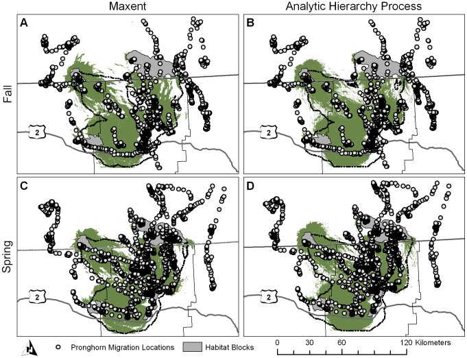
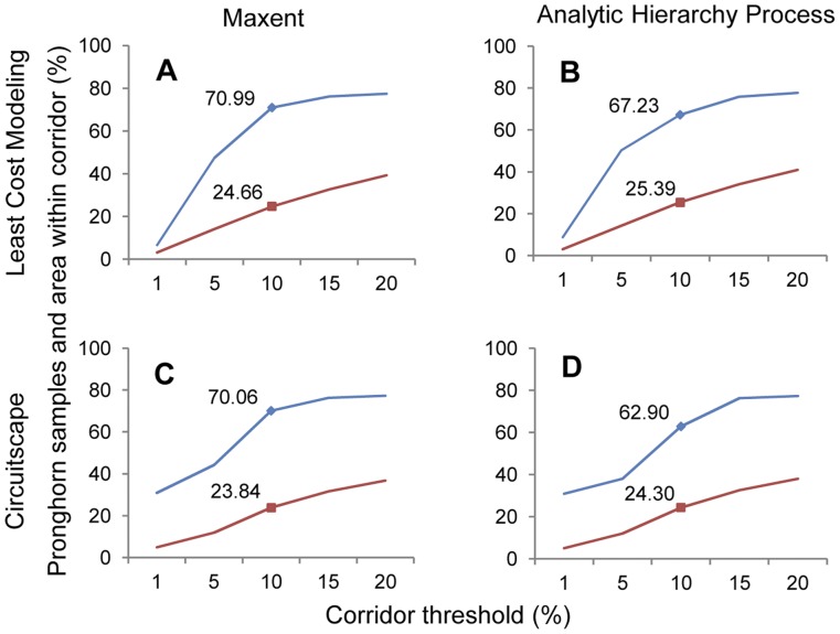
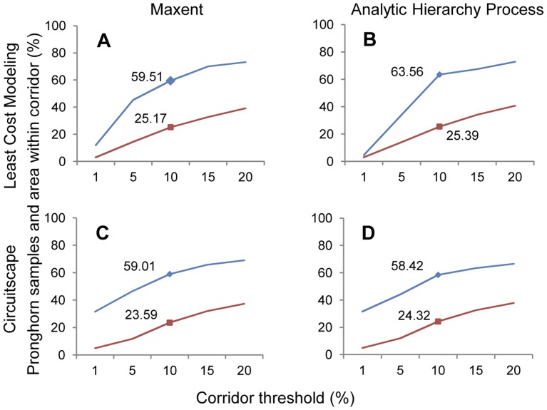
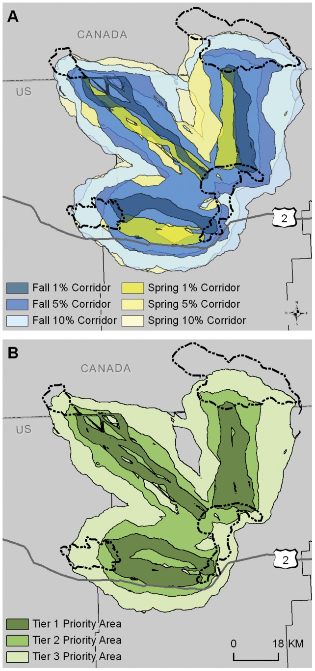
Terrestrial long-distance migrations are declining globally: in North America, nearly 75% have been lost. Yet there has been limited research comparing habitat suitability and connectivity models to identify migration corridors across increasingly fragmented landscapes. Here we use pronghorn (Antilocapra americana) migrations in prairie habitat to compare two types of models that identify habitat suitability: maximum entropy (Maxent) and expert-based (Analytic Hierarchy Process). We used distance to wells, distance to water, NDVI, land cover, distance to roads, terrain shape and fence presence to parameterize the models. We then used the output of these models as cost surfaces to compare two common connectivity models, least-cost modeling (LCM) and circuit theory. Using pronghorn movement data from spring and fall migrations, we identified potential migration corridors by combining each habitat suitability model with each connectivity model. The best performing model combination was Maxent with LCM corridors across both seasons. Maxent out-performed expert-based habitat suitability models for both spring and fall migrations. However, expert-based corridors can perform relatively well and are a cost-effective alternative if species location data are unavailable. Corridors created using LCM out-performed circuit theory, as measured by the number of pronghorn GPS locations present within the corridors. We suggest the use of a tiered approach using different corridor widths for prioritizing conservation and mitigation actions, such as fence removal or conservation easements.
Conflict of interest statement
Figures
Similar articles
-
Multi-scale habitat assessment of pronghorn migration routes.PLoS One. 2020 Dec 4;15(12):e0241042. doi: 10.1371/journal.pone.0241042. eCollection 2020. PLoS One. 2020. PMID: 33275623 Free PMC article.
-
Identifying impediments to long-distance mammal migrations.Conserv Biol. 2015 Feb;29(1):99-109. doi: 10.1111/cobi.12376. Epub 2014 Aug 26. Conserv Biol. 2015. PMID: 25158993
-
Modeling fence location and density at a regional scale for use in wildlife management.PLoS One. 2014 Jan 8;9(1):e83912. doi: 10.1371/journal.pone.0083912. eCollection 2014. PLoS One. 2014. PMID: 24416180 Free PMC article.
-
[Evaluation of landscape connectivity based on least-cost model].Ying Yong Sheng Tai Xue Bao. 2009 Aug;20(8):2042-8. Ying Yong Sheng Tai Xue Bao. 2009. PMID: 19947231 Review. Chinese.
-
Connecting science, policy, and implementation for landscape-scale habitat connectivity.Conserv Biol. 2016 Oct;30(5):950-61. doi: 10.1111/cobi.12667. Epub 2016 Aug 20. Conserv Biol. 2016. PMID: 26648510 Review.
Cited by
-
Modeling Raccoon (Procyon lotor) Habitat Connectivity to Identify Potential Corridors for Rabies Spread.Trop Med Infect Dis. 2017 Aug 28;2(3):44. doi: 10.3390/tropicalmed2030044. Trop Med Infect Dis. 2017. PMID: 30270901 Free PMC article.
-
Modelling elephant corridors over two decades reveals opportunities for conserving connectivity across a large protected area network.PLoS One. 2023 Oct 13;18(10):e0292918. doi: 10.1371/journal.pone.0292918. eCollection 2023. PLoS One. 2023. PMID: 37831668 Free PMC article.
-
Multiscale consensus habitat modeling for landscape level conservation prioritization.Sci Rep. 2020 Oct 20;10(1):17783. doi: 10.1038/s41598-020-74716-3. Sci Rep. 2020. PMID: 33082467 Free PMC article.
-
Suitable Habitats of Chrysolophus spp. Need Urgent Protection from Habitat Fragmentation in China: Especially Suitable Habitats in Non-Nature Reserve Areas.Animals (Basel). 2022 Aug 11;12(16):2047. doi: 10.3390/ani12162047. Animals (Basel). 2022. PMID: 36009637 Free PMC article.
-
A spatial genetics approach to inform vector control of tsetse flies (Glossina fuscipes fuscipes) in Northern Uganda.Ecol Evol. 2018 May 4;8(11):5336-5354. doi: 10.1002/ece3.4050. eCollection 2018 Jun. Ecol Evol. 2018. PMID: 29938057 Free PMC article.
References
-
- Berger J (2004) The last mile: how to sustain long-distance migration in mammals. Conserv Biol 18: 320–331.
-
- Bolger DT, Newmark WD, Morrison TA, Doak DF (2008) The need for integrative approaches to understand and conserve migratory ungulates. Ecol Lett 11: 63–77. - PubMed
-
- Harris G, Thirgood S, Hopcraft JGC, Cromsigt JPGM, Berger J (2009) Global decline in aggregated migrations of large terrestrial mammals. Endang Sp Res 7: 55–76.
Publication types
MeSH terms
LinkOut - more resources
Full Text Sources
