. 2012;7(11):e49809.
doi: 10.1371/journal.pone.0049809. Epub 2012 Nov 14.

Giant robber crabs monitored from space: GPS-based telemetric studies on Christmas Island (Indian Ocean)

Affiliations

Giant robber crabs monitored from space: GPS-based telemetric studies on Christmas Island (Indian Ocean)

Jakob Krieger et al. PLoS One. 2012.

Abstract

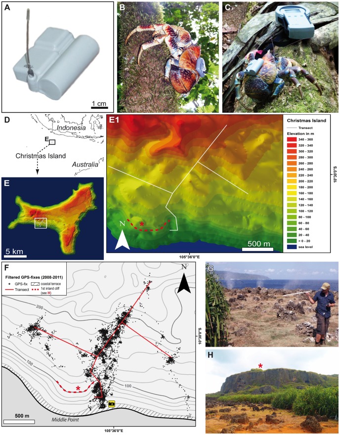
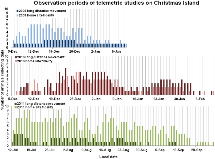
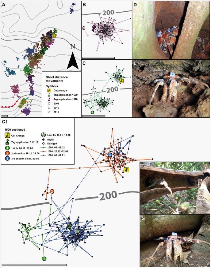
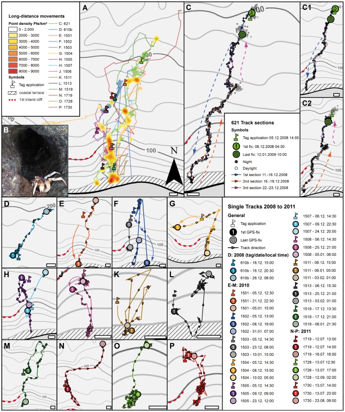
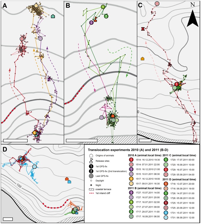
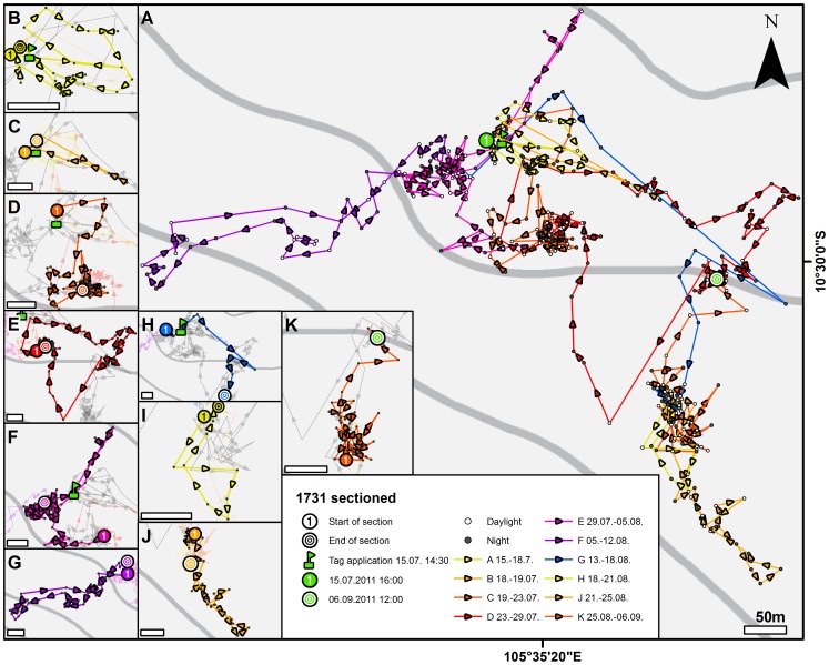
We investigated the navigational capabilities of the world's largest land-living arthropod, the giant robber crab Birgus latro (Anomura, Coenobitidae); this crab reaches 4 kg in weight and can reach an age of up to 60 years. Populations are distributed over small Indo-Pacific islands of the tropics, including Christmas Island (Indian Ocean). Although this species has served as a crustacean model to explore anatomical, physiological, and ecological aspects of terrestrial adaptations, few behavioral analyses of it exist. We used a GPS-based telemetric system to analyze movements of freely roaming robber crabs, the first large-scale study of any arthropod using GPS technology to monitor behavior. Although female robber crabs are known to migrate to the coast for breeding, no such observations have been recorded for male animals. In total, we equipped 55 male robber crabs with GPS tags, successfully recording more than 1,500 crab days of activity, and followed some individual animals for as long as three months. Besides site fidelity with short-distance excursions, our data reveal long-distance movements (several kilometers) between the coast and the inland rainforest. These movements are likely related to mating, saltwater drinking and foraging. The tracking patterns indicate that crabs form route memories. Furthermore, translocation experiments show that robber crabs are capable of homing over large distances. We discuss if the search behavior induced in these experiments suggests path integration as another important navigation strategy.


Conflict of interest statement

Competing Interests: The authors have declared that no competing interests exist.

Figures

Figure 1
Figure 1. Animals and tags.
A: Photograph of the e-obs GPS-tag (2nd tag version with single battery used in 2010 and 2011). B Tagged Birgus latro escaping into a tree (1st tag version with twin batteries used in 2008). C Tagged B. latro (2nd tag version) inspecting the BaseStation for wireless data download (image kindly provided by Meike Kilian). D Location of Christmas Island, Indian Ocean. E, E1 Geo-referenced 3D model of Christmas Island showing the study area at Aldrich Hill and the transect. F Topographic map displaying the filtered data set of 9,272 GPS fixes recorded in all three expeditions. The camera symbol shows the position from which G and H were taken. G, H Photographs of the coastal terrace. G shows the first author tracking radio signals near the blowholes which can be identified by the three spray plumes in the background (image kindly provided by Meike Kilian). H is taken facing north-west and the photo shows the rocky coastal terrace, the dense belt of Pandanus and in the background the vertical first inland cliff. For positions of asterisk, see F.
Figure 2
Figure 2. Observation periods of telemetric studies on Christmas Island.
Colored bars indicate the number of animals/transmitters receiving at least one GPS fix per day. Stationary (brighter colored bars) animals are opposed to animals showing large-distance migrations (darker colored bars) daywise (for details see text).
Figure 3
Figure 3. Linear correlation of horizontal error estimate and exact horizontal error.
Horizontal deviations in m from stationary tags of known positions under open sky conditions (red crosses) and within the rain forest (blue diamonds) of Christmas Island.
Figure 4
Figure 4. Circadian rhythm of locomotory behavior. Upper panel:
Relative activity = percentage of mean distances between GPS-fixes per total number of GPS-fixes ± SD [percentage of m/fix]. Horizontal bars indicate times of daylight (white) and night (black). Lower panel: Daily fluctuations of GPS fixes of all attached tags of the 2008, 2010, and 2011 missions (colored solid lines) and a stationary test tag (black dashed line). Data suggest that many animals hide in refuges during daytime thus blocking GPS reception. During the 2008 and 2010 missions (wet season) migratory activity of the animals begins at dusk to reach a maximum between 20:00 and 22:00.
Figure 5
Figure 5. Site fidelity.
A: Overview of all animals showing site fidelity and short-distance movements only from all three years of observations. B: Higher magnification of animal No. 1520 that remained within one home range during the plotted period (19 December 2010 to 09 January 2011); open symbols: daytime fixes, solid symbols: nighttime fixes. C and C1: higher magnifications of animal 1500 that occupied three home ranges between 5 December 2010 and 17 January 2011. In C1 this period is sectioned in three episodes. D: B. latro uses hollow trees as daytime refuges. E: A tagged animal hiding in a rock crevice during the day. F, G: B. latro are strongly attracted to freshly fallen Lister's palms. Cut Arenga: site of a freshly fallen Arenga listeri palm. Scale bars in A, B, C, C1: 100 m.
Figure 6
Figure 6. Long-distance Y-axis migrations.
A: Overview of all animals showing long-distance movements within a migratory corridor that extends from the coastal terrace ca. 2 km inland (data pooled from all three missions). Color ranges define point density estimates in points per km2 using only data of directed movements (points of stationary phases or undirected movements were removed) B: One of several animals exposed to ocean spray as observed in the upper openings of the blowholes at the coastal terrace (compare Fig. 1J). C: example of migratory animal No. 621, monitored from 5 December 2008 to 12 January 2009, and displaying typical Y-axis migration (with the X-axis being the shoreline) during this period. C1 and C2 section this migration into the outbound and inbound episodes. Note that in- and outbound paths are identical (permitting for the GPS error of max. 20 m); open symbols: daytime fixes, solid symbols: nighttime fixes. D–P: higher magnifications of all animals showing long-distance movements. For every animal, position and date (see boxed legend) of the tag application is plotted as well as dates and positions of the first and last obtained GPS fixes. Scale bars: 100 m.
Figure 7
Figure 7. Displacement experiments and homing.
A, B: Homing course of animals that were picked up at the house symbols and translocated in Y-axis direction towards the flagged release sites in the south (A) or the north (B). For all animals, the date (see boxed legend) and position of the first and last GPS fixes are given in addition to the track. Note that animal No. 1717 (green in B) was translocated twice and both times homed back to its pick-up site on an identical path. C: Two animals that were picked up at the house symbols and translocated roughly parallel to the coast out of the migratory corridor towards the flagged release sites in the east. Whereas animal No. 1720 remained in the release area, No. 1729 migrated to the coast, but ca. 1.5 km east of the regular migratory corridor. It then reversed its path to migrate far north past the release site. D: Two animals, Nos. 1725 and 1731, translocated roughly parallel to the coast out of the migratory corridor towards the flagged release sites in the west did not home back to the pickup area (orange symbols). Two animals translocated from north to south (blue symbols) within the migratory corridor during the 2011 mission also remained within the release area. Scale bars: 200 m.
Figure 8
Figure 8. Displacement-induced search behavior.
A: higher magnification of animal No. 1731 that was translocated roughly parallel to the coast out of the migratory corridor towards the west (compare pale blue line in Fig. 5D) and monitored from 15 July to 9 September 2011. The animal's behavior is much different from that of animals with typical site fidelity (compare Fig. 3B, C). B–K: Search behavior sectioned in ten migratory episodes (for dates, compare boxed legend) shows excursions in almost all compass directions. Scale bars: 50 m.

References

    1. Wikelski M, Kays RW, Kasdin NJ, Thorup K, Smith JA, et al. (2007) Going Wild: What a Global Small-Animal Tracking System Could Do for Experimental Biologists. J Exp Biol 210: 181–186. - PubMed
    1. Sims DW, Queiroz N, Humphries NE, Lima FP, Hays GC (2009) Long-Term GPS Tracking of Ocean Sunfish Mola mola Offers a New Direction in Fish Monitoring. PLoS ONE 4: e7351. - PMC - PubMed
    1. Tsoar A, Nathan R, Bartan Y, Vyssotski A, DellOmo G, et al. (2011) Large-scale navigational map in a mammal. PNAS 108: E718–E724. - PMC - PubMed
    1. Cheng K, Narendra A, Sommer S, Wehner R (2009) Traveling in clutter: Navigation in the Central Australian desert ant Melophorus bagoti . Behav Process 80: 261–268. - PubMed
    1. Collett M, Collett TS (2000) How do insects use path integration for their navigation? Biol Cybern 83: 245–259. - PubMed

Publication types