. 2012:2:970.
doi: 10.1038/srep00970. Epub 2012 Dec 13.

The tectonic puzzle of the Messina area (Southern Italy): insights from new seismic reflection data

Affiliations

The tectonic puzzle of the Messina area (Southern Italy): insights from new seismic reflection data

Carlo Doglioni et al. Sci Rep. 2012.

Abstract

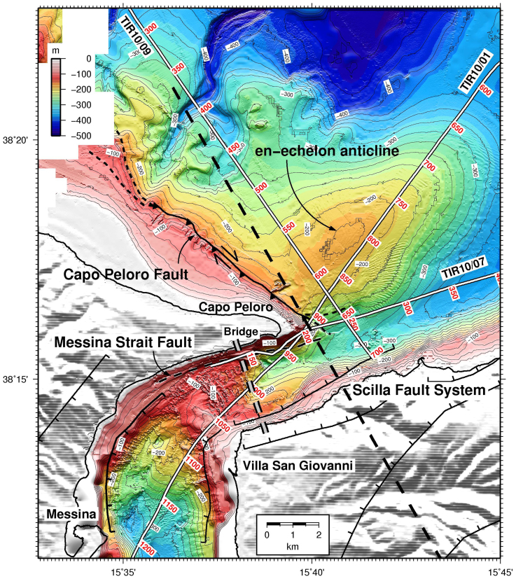
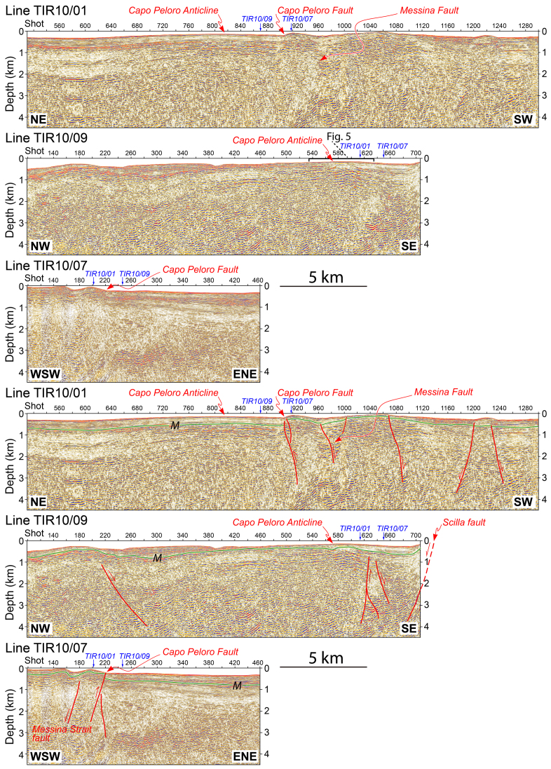
The Messina Strait, that separates peninsular Italy from Sicily, is one of the most seismically active areas of the Mediterranean. The structure and seismotectonic setting of the region are poorly understood, although the area is highly populated and important infrastructures are planned there. New seismic reflection data have identified a number of faults, as well as a crustal scale NE-trending anticline few km north of the strait. These features are interpreted as due to active right-lateral transpression along the north-eastern Sicilian offshore, coexisting with extensional and right-lateral transtensional tectonics in the southern Messina Strait. This complex tectonic network appears to be controlled by independent and overlapping tectonic settings, due to the presence of a diffuse transfer zone between the SE-ward retreating Calabria subduction zone relative to slab advance in the western Sicilian side.


Figures

Figure 1
Figure 1. Geological setting of the Messina Strait, with location of the planned bridge (gray solid line), and of the seismic reflection profile TIR10/01 (white line).
This area is shaped by a complex network of normal and transtensional faults (black lines with ticks). Depth of the top of the subducted Ionian slab (ref. and references therein) is also shown (black lines). Red, blue and green dots are earthquake epicentres, occurring at depths < 15 km, between 15 and 35 km, and > 35 km, respectively (http://csi.rm.ingv.it). Focal plane solutions are from ref. . Red arrows indicate GPS velocity vectors. Black rectangle is the survey area of Fig. 2. Lower-right panel shows a tectonic sketch of the southern Tyrrhenian Sea, representing coexisting compression (solid red arrows) along the northeastern Sicilian offshore, and extension (open red arrows) in southern Calabria.
Figure 2
Figure 2. Morpho-structural map of the Messina Strait, with location of the scarp of the Capo Peloro fault, of the blind Messina Strait Fault (dashed black line), and of the Scilla Fault System.
The adjacent anticline to the north is located at the eastern tip line of the Capo Peloro fault. The fold axis to the northeast is en-échelon with respect to the E-W-trending right-lateral transpression offshore northern Sicily, and slightly en-échelon with respect to the Capo Peloro fault. The white lines indicate locations of seismic profiles, with shot points, TIR10/01, TIR10/07 and TIR10/09 (Figs. 3 and 4, Supplementary Figs. S2, S8, S9 and S10). The thick grey and black dashed lines indicate the planned bridge and the cross section shown in Fig. 6, respectively.
Figure 3
Figure 3. High resolutions pre-stack time migrated seismic reflection profile TIR10/01 (top: uninterpreted; bottom: interpreted).
Moving from the left side (NE), there are two canyons cutting into the Plio-Pleistocene sequence. The Messinian unconformity (green solid line, M) covers an undifferentiated and tectonized basement (Hercynian and Alpine metamorphic rocks, Mesozoic passive margin and Cenozoic active margin sequences). The Messinian strong reflectors are inferred as evaporites which pinch-out and possibly disappear toward the southwest. The yellow line is an intra Pleistocene unconformity. In the central part of the section a crustal scale anticline actively deforms the seafloor and the whole underlying sequence. The Capo Peloro fault is inferred as active, since it offsets the seafloor, and based on the steep attitude and the regional context, it is inferred as right-lateral transpressive fault. The Messina Strait is sitting on top of a normal-fault-propagation syncline determining the morphology of the Strait itself. The Pleistocene sequences show growth geometry, suggesting syntectonic sedimentation all along the cross-section. Therefore, both contractional or transpressive features coexist with tensional faults. Profile location is indicated in Fig. 2. The black line on top of the upper panel marks the portion of profile TIR10/01 shown in Fig. S10.
Figure 4
Figure 4. Post-stack depth migrated seismic profiles TIR10/01 (from shot point 510 to 1300), TIR10/07 and TIR10/09 (top: uninterpreted; bottom: interpreted).
The Messinian unconformity (M) is shown by a solid green line. The Plio-Pleistocene sequence rests unconformably on M and lies above an undifferentiated "basement", ranging from Messinian evaporites down to the metamorphic hercynian or alpine rocks. Notice the coexistence of normal faults, the Capo Peloro reverse fault, and the adjacent anticline. Location of the profiles is in Fig. 2. The black line on top of the upper panel marks the portion of profile TIR10/09 shown in Fig. 5.
Figure 5
Figure 5. Close-up and seismic-derived instantaneous attributes of portion of the seismic reflection profile TIR10/09, showing structural details of the Capo Peloro anticline.
a, time migration. b, reflection strength. The instantaneous amplitude measures the reflectivity strength which is proportional to the square root of the total energy of the seismic signal at an instant of time. Note the lack of reflection energy just beneath the ~7 m seafloor step located on the summit of the Capo Peloro anticline. c, instantaneous phase. This seismic attribute emphasizes the continuity of events on a seismic section. Reflection strength, instantaneous phase and seismic section panels show clearly a small thrust cutting the summit of the anticline and offsetting the seafloor, confirming the recent activity of the structure.
Figure 6
Figure 6. Morpho-bathymetry of the Messina Strait area and cross-section geological interpretation.
View from northeast. Bathymetry from Fig. 2. The geological cross section has been obtained from the data of three seismic lines of the TIR10 cruise shown in Fig. 4 (TIR10/01, TIR10/07, TIR10/09), s.l. – sea level. All the data were elaborated using Move 2011 (http://www.mve.com/). Notice the normal fault of the Messina Strait gradually transferring to the northeast into the Scilla Fault. The Messina graben is here asymmetric, having a thicker syntectonic sedimentary package in the northwestern margin. The Capo Peloro transpressive fault indicates a different tectonic setting. In few km, two independent and coexisting stress fields act in the same region.
Figure 7
Figure 7. Block diagram showing the geometry of the Apennines-Calabrian subduction zone, the differential advancement/retreat of the slab hinge relative to the Sardinia upper plate, in comparison with the Sicilian segment, and the state of stress at the surface.
The Messina Strait area is located at the transfer zone where the two tectonic mechanisms partly overlap.

References

    1. Pino N. A., Piatanesi A., Valensise G. & Boschi E. The 28 December 1908 Messina Straits earthquake (M(w)7.1): a great earthquake throughout a century of seismology. Seismol. Res. Lett. 80, 243–259 (2009).
    1. Baratta M. La catastrofe sismica Calabro-Messinese (28 Dicembre 1908), pp 496, Società Geografica ItalianaRoma (1910).
    1. Boschi E., Guidoboni E., Ferrari G., Valensise G. & Gasperini P. Catalogo dei Forti Terremoti in Italia dal 461 a.C. al 1990. pp. 644, ING Roma-SGA, Bologna. (1997).
    1. Billi A., Funiciello R., Minelli L., Faccenna C., Neri G., Orecchio B. & Presti D. On the cause of the 1908 Messina tsunami, southern Italy. Geophys. Res. Lett. 35, L06301 (2008).
    1. Doglioni C., Merlini S. & Cantarella G. Foredeep geometries at the front of the Apennines in the Ionian Sea (central Mediterranean). Earth Planet. Sci. Lett. 168, 243–254 (1999).